Forecast for the Salt Lake Area Mountains

Trent Meisenheimer
Issued by Trent Meisenheimer for
Wednesday, March 25, 2020
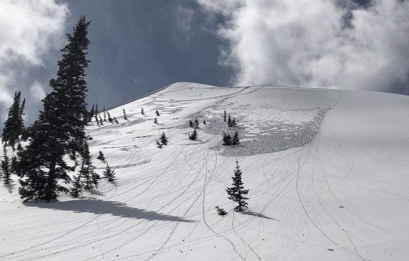
The avalanche danger is CONSIDERABLE on all upper elevation steep slopes for triggering fresh drifts of windblown snow (wind slabs). Careful snowpack evaluation, cautious route-finding, and conservative decision-making will be essential in this terrain today.
Out of the wind-loaded terrain, there is a MODERATE danger on all slopes at the mid and upper elevations for triggering a new snow (soft slab) avalanche that fails within the storm snow. Evaluate the snow and terrain carefully; identify features of concern and avoid those areas.

Keep in mind that if it starts snowing harder than expected or the sun comes out for any reason the avalanche danger can spike rapidly.
Low
Moderate
Considerable
High
Extreme
Learn how to read the forecast here
Special Announcements
UAC operating schedule - We will continue issuing regular avalanche forecasts into mid-April.
Spring Awareness Campaign - The UAC counts on donations from the backcountry community. We know these are uncertain times, and any donation during our awareness campaign will help us continue providing avalanche forecasting and education.
CDC Guidelines - Even in the backcountry and in parking lots, please follow CDC guidelines like limiting group size and keeping a distance of at least 6 feet from other people to protect yourself and others. Read the guidelines HERE.
Taking risks - Be extra conservative to avoid the risk of accidents, which can stress the capacity of our medical system.
Skiing and riding at closed ski resorts - Some resorts allow access now, and some do not. Please check HERE for the latest info on ski area access.
New to the backcountry (including riding at closed resorts) - Watch the award-winning, 15 minute Know Before You Go video, or take the 5-part, free online-learning series.
Weather and Snow
Winter storm warning will continue until 10:00 pm Thursday. Yesterday afternoon the westerly wind picked up and continued overnight averaging 20-30 mph gusting to 50 along the mid and upper elevation ridgelines. Currently, the winds are from the west and blowing 5-15 mph at the upper elevations, and it seems they've died down a bit since the overnight hours as some stations are dead calm.
In the past 24 hrs, we've added 4-8" of new snow (0.34" - 0.90" water), bringing storm totals to 10-12 inches of new snow containing 1.25" inches of water at the upper elevations. Areas favored by a southwest flow might have squeezed out a few more inches than this.
We can expect snowfall for much of the morning before it tapers off this afternoon. Mountain temperatures will remain cold, and the westerly winds will continue to blow with speeds of 10-20 mph for much of the day. Just as we think the storm is over, it will re-intensify later this evening, and we get another round of heavy snowfall overnight.
Recent Avalanches
We had many reports of avalanches failing within the storm snow 6" to 8" inches deep and up to 100' feet wide. These avalanches were failing close to the old snow surface, and graupel was likely the weak layer. Riders also reported the new snow was sluffing easily in steep terrain.
The most surprising avalanche was in Millcreek Canyon off Little Water Peak, where a rider triggered a slab avalanche that was only 1" inch deep. Still, it propagated almost 100' feet wide, most likely failing on graupel. What makes this surprising is the depth being very shallow. Now add another 10" of snow to this set up, and I think we could be seeing larger avalanches today. (Photo: Cam)
Ad
Avalanche Problem #1
New Snow
Type
Location
Likelihood
Size
Description
Roughly 8" to 12" inches of new snow has fallen throughout the Wasatch range. The snow kicked off with a period of graupel, then followed by dense, heavy snow. For slab avalanches, we need a weak layer and a slab. The graupel has the potential to be the weak layer, and the new snow on top is the slab. I would expect the new snow to be reactive this morning and by later this afternoon trending towards stable. These soft slab avalanches would be a foot deep, and 100' wide and are large enough to catch, carry, or bury us.
The good news - this new snow issue should be easy to get a handle on how stable or unstable the snow is today. Use test slopes to see how the new snow is behaving, take your shovel out, and perform a shovel tilt test or an extended column test to see if there is any propagation within the new snow. Look for the obvious clues, recent avalanche activity, and shooting cracks.
Hot Tip: Low angle terrain was riding better yesterday than the steeper, more avalanche-prone terrain. Slopes under 30° in steepness provide fast, creamy turns and are low risk, high reward.
Avalanche Problem #2
Wind Drifted Snow
Type
Location
Likelihood
Size
Description
In the wind zone, the new snow problem will be amplified by additional loading by the wind. The westerly winds have been blowing 20-30 mph steadily for the past 12 hrs. This problem will be most pronounced on steep slopes facing north, northeast, east, southeast, and south. As always, be on the lookout and avoid snow that looks textured, rounded, and pillowy - especially just off the upper ridgelines today.
General Announcements
This information does not apply to developed ski areas or highways where avalanche control is normally done. This forecast is from the U.S.D.A. Forest Service, which is solely responsible for its content. This forecast describes general avalanche conditions and local variations always occur.