Join us at our 2nd Annual Blizzard Ball

Forecast for the Salt Lake Area Mountains

Drew Hardesty
Issued by Drew Hardesty on
Monday morning, March 2, 2020
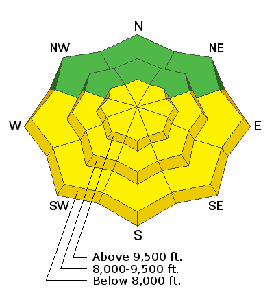
Sunny skies today will warm the 4-10” of light fresh snow fall from yesterday. MODERATE danger will develop for sunny aspects as they warm due to loose wet avalanches at all elevations. At the highest elevations MODERATE danger exists on all aspects due to shallow fresh windslabs. Shallow loose-dry sloughs will remain possible.
Evaluate terrain carefully, and pay attention to your aspects and timing.
Low
Moderate
Considerable
High
Extreme
Learn how to read the forecast here
Special Announcements
The UAC's Avy Awareness Auction is currently underway with tons of great gear, jewelry, artwork and experiences available. Visit the auction page HERE to help support the UAC's spring avalanche awareness and outreach efforts.

A new version of the UAC IOS application is now available on the Apple App Store. This version fixes many of the issues that occur when running IOS 13. Download it now!
Weather and Snow
Light snow fell throughout the day yesterday with storm totals ranging mostly between 4-10” with light winds except at the highest elevations that gusted up to 20mph. The southwest wind direction shifted clockwise to the northeast overnight but has since backed to the northwest.
Sunny skies and brisk temperatures are on-tap for the day with mostly light northwest winds gusting into the 30s at the highest elevations. Single digits early this morning will warm up into the low to mid teens up high.
High pressure should continue thru the week, with increased winds towards the weekend as weak low pressure moves in.

Today's avalanche advisory written by visiting Eastern Sierra Avalanche Center forecaster Josh Feinberg.
Recent Avalanches
Shallow loose-dry sloughs were easily triggered yesterday in steep terrain. In the steepest terrain with underlying firm crusts, sloughs were reported to run fast with debris piles enough to bury a person.
Ad
Avalanche Problem #1
Wet Snow
Type
Location
Likelihood
Size
Description
Sunny skies today will quickly warm the 4-10” of light new snowfall from yesterday on sunny aspects. Natural and human triggered loose wet sloughs will become likely on east through south through west slopes as them warm. Pay attention to snow surfaces becoming moist and sticky, and watch for signs such as rollerballs indicating that larger wet releases could become possible. Be especially careful steep confined terrain that funnels snow from different aspects above, where a slide could certainly be large enough to take a person off their feet and flush them downslope. Firm underlying crusts could cause these slides to run far.
Avalanche Problem #2
Wind Drifted Snow
Type
Location
Likelihood
Size
Description
At the highest elevations with gusts in the 20-30mph range, watch for small pockets of denser wind loaded snow just below ridge lines, sidewalls of gullies and around other cross-loaded features. The winds shifted mid-storm yesterday so all aspects could be concerning.
Small loose dry sloughs will continue to be possible.
General Announcements
This information does not apply to developed ski areas or highways where avalanche control is normally done. This forecast is from the U.S.D.A. Forest Service, which is solely responsible for its content. This forecast describes general avalanche conditions and local variations always occur.