Sign Up for the Utah Snow and Avalanche Workshop (USAW) on December 7th!

Forecast for the Salt Lake Area Mountains

Nikki Champion
Issued by Nikki Champion on
Sunday morning, March 15, 2020
Today, a MODERATE avalanche danger exists on all mid and upper elevation slopes. Wind drifts remain the primary concern and are most pronounced, but not isolated to, steep north to east-facing slopes where triggering both a hard or soft slab is possible. A LOW avalanche danger exists on all low elevations, where generally safe avalanche conditions exist.
Lose a little elevation and avoid slopes with fresh wind drifting, and you'll avoid most avalanches today.
Low
Moderate
Considerable
High
Extreme
Learn how to read the forecast here
Special Announcements
We know there is a lot of uncertainty regarding the Coronavirus, but the Utah Avalanche Center is planning to continue issuing regular avalanche forecasts into April.
Alta Ski Area, Park City Mountain Resort and the Canyons are closed to uphill travel - check your specific ski resort for uphill travel policies during the upcoming closures.
Weather and Snow
This morning mountain temperatures are in the low 30s F at trailheads and low 20s F at ridgelines. Winds are currently south southwesterly and cranking, averaging 20-40 mph, with gusts up to 60 mph at mid-elevation ridgelines. At 11,000 winds are averaging 30-40 mph, with gusts near 80 mph.
In the last 24 hours, most parts of the Central Wasatch got 1-4 inches of new snow (.02-.44" SWE). Upper Big Cottonwood Canyon was favored in the storm and the Brighton area got up to 7 inches of snow (.97" SWE).
Today occasional light snow showers will continue into the evening, bringing another 1-2 inches of snow to the region. Temperatures will be the mid-40s F at trailheads and mid-30s F at ridgelines. Winds will continue to crank from the southwest, averaging 20-30 mph with gusts up to 50 mph at mid-elevations and gusts up to 85 mph at upper elevations.

Our Week in Review - where we summarize snow, weather, and avalanche activity over the past week, is available HERE.
Recent Avalanches
Yesterday multiple shallow soft slab avalanches were reported in the backcountry. In Upper Mary Chutes, one skier triggered a shallow soft slab of wind drifted snow on a North aspect at 9800' that broke 50' wide.
Below is a photo of the shallow slab of wind drifted snow from Upper Mary Chutes. (Photo: slp)
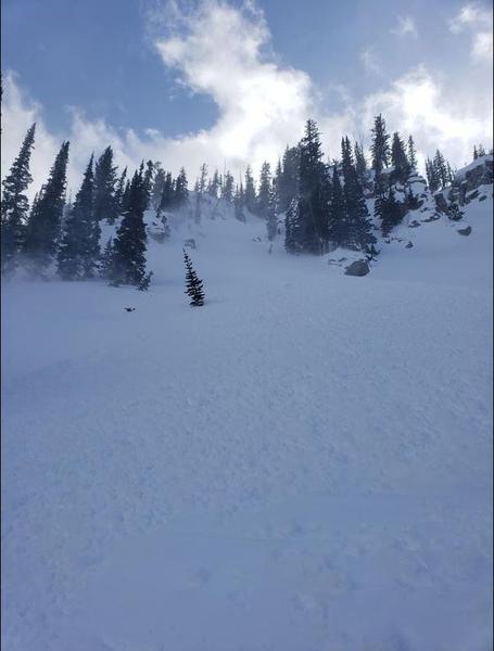
Ski areas reported sensitive slabs of wind drifted snow on leeward slopes.
Ad
Avalanche Problem #1
Wind Drifted Snow
Type
Location
Likelihood
Size
Description
Over the last two days, winds have remained strong enough to drift snow, with gusts near 80 mph at the highest of ridgelines. Today these drifts will be most widespread on north through east-facing slopes, especially at the highest most elevations. However, sustained high winds can deposit snow around terrain features on almost any aspect, called cross-loading. For this reason, I would expect to find sensitive slabs of wind drifted snow at all upper and mid-elevation slopes, especially along with terrain features such as ridgelines, sub ridges, and gullies.
While these winds don't have a ton of new snow to work with, such strong winds today will continue to form both soft and hard slab avalanches in upper elevation wind drifted terrain. As the winds continue to blow, these slabs will become more firm and cohesive. This can allow you to travel out farther onto the slope before it breaks, and can fail larger and wider than expected. Approach each new drift with caution.
Today continue to look for slopes with any signs of wind drifted snow, such as cracking, hollow noises, and pillow-shaped snow and avoiding those slopes.

Travel Advice: Avoid wind drifted terrain and avoid the problem, look for mid-elevation wind-sheltered terrain.
Avalanche Problem #2
New Snow
Type
Location
Likelihood
Size
Description
In areas that got higher precipitation totals, such as Upper Big Cottonwood Canyon, and are protected from the wind some sensitive storm snow may still exist. This could include long-running sluffs or a shallow sensitive storm slab. Graupel pooling may also be founded beneath cliffbands and on slope transitions where graupel may pool deeply. These instabilities may be found on all aspects.
Be especially thoughtful of this while traveling above terrain traps, cliff bands and features in which the debris from even a shallow slab could pile up.
General Announcements
This information does not apply to developed ski areas or highways where avalanche control is normally done. This forecast is from the U.S.D.A. Forest Service, which is solely responsible for its content. This forecast describes general avalanche conditions and local variations always occur.