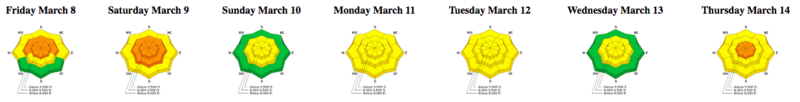
Forecast for the Salt Lake Area Mountains

Evelyn Lees
Issued by Evelyn Lees for
Friday, March 15, 2019
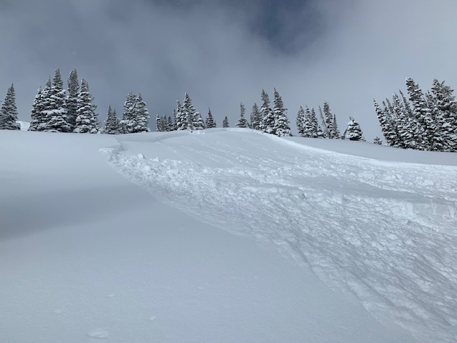
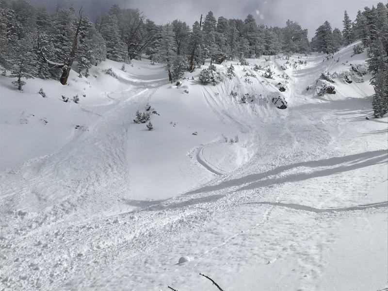
The avalanche danger is mostly LOW early this morning, but will rapidly increase to CONSIDERABLE for Wet Snow avalanches on and below steep, sunny slopes and on all low elevation slopes. When the snow becomes damp, get off of and out from under the steep slopes, as wet sluffs will be easy to trigger and natural avalanches will occur. Have an exit plan that avoids steep, low elevation terrain.
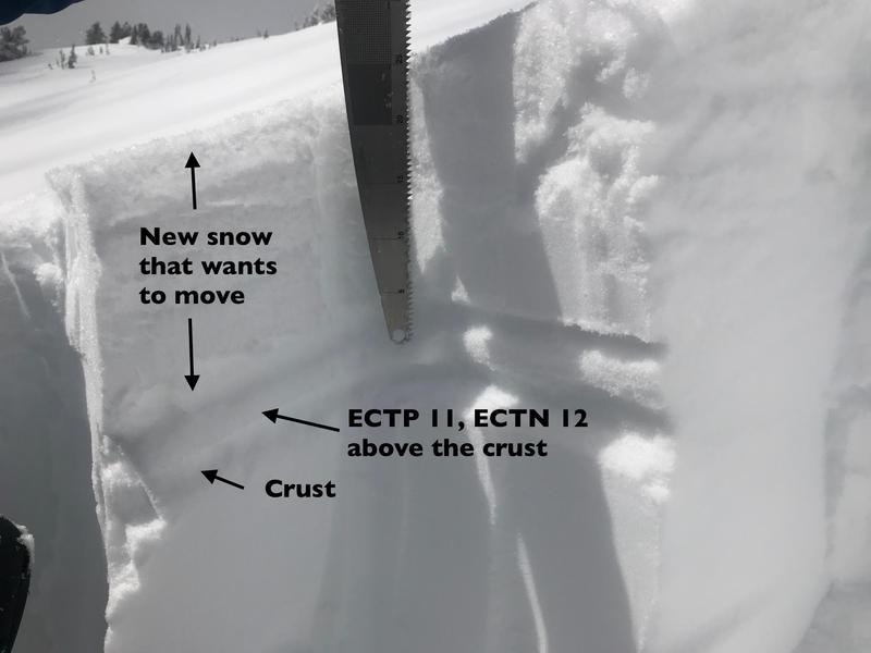
On upper elevation, shady slopes isolated New Snow storm slabs and sluffs can be triggered in steep terrain.
Low
Moderate
Considerable
High
Extreme
Learn how to read the forecast here
Special Announcements
The latest podcast is out! The Wise Ones - A Conversation About Mentorship with Eeva Latosuo and Aleph Johnston-Bloom. LINK
Weather and Snow
This morning is the last chance for a few more hours of superb, widespread powder before the sun does it’s damage today. Wednesday’s storm left 33” in upper Little Cottonwood and 25” in lower/mid Big Cottonwood, both favored by northwest flow. Most other parts of the Cottonwoods, Millcreek and the Park City ridgeline received 12 to 18”.
Under clear skies, temperatures this morning are in the single digits and low teens, with a slight inversion putting the coolest temperatures in the canyon bottoms. Winds are from the northwest and only a bit stronger than yesterday along the upper elevation ridge lines - averaging 5 to 15 mph, gusting 15 - 20 mph.
Sadly, serious high pressure is moving in, with clear skies and warming temperatures today through the weekend. Temperatures will reach the low 30s at 8,000’ and mid 20s at 9,000’ today, with winds remaining very light at the mid and low elevations. Even the upper elevation ridge lines will only have averages in the 10 to 15 mph range.
Recent Avalanches
There were several skier triggered new snow slabs yesterday, large enough to take you for a ride. They averaged 50 - 150' wide, consisting of storm snow only, most running on the sun crusts beneath the new snow. The resorts triggered slightly larger slides with explosives. Small dry and wet loose sluffs also ran.
First photo: just south of Georges Bowl, Cardiff. Anne Perry photo
Second photo: Greaseball, Kessler. The slide ran about 1,000' in the continuously steep terrain.
Ad
Avalanche Problem #1
Wet Snow
Type
Location
Likelihood
Size
Description
The amazing low-density snow from Wednesday’s storm will rapidly heat today under the strong March sun. The snow will dampen quickly, producing both natural wet avalanches and easily human triggered wet sluffs. With a good crust to run on, slides may fan out and run further than expected. The snow on low elevation north aspects will also heat, and has the potential to sluff today as well.
Keep eyes peeled for roller balls and cakey snow, clues of heating. Get on and off solar aspects early. Think about exits today, avoiding steep gullies and drainages - even the steep north facing gullies may run naturally today. With warming temperatures roofs may start shedding their snow and cornices will become sensitive again.
Don’t forget your skin wax and scraper today!
Avalanche Problem #2
New Snow
Type
Location
Likelihood
Size
Description
On upper elevation shady slopes the new snow is settling and bonding to the old snow surface. However, in isolated areas there is potential to trigger new snow soft slabs and sluffs. Even though they are small, if you're in rowdy terrain that's continuously steep or above cliffs, consequences can be high.
Wet or dry, it's the new snow that wants to slide.
General Announcements
This information does not apply to developed ski areas or highways where avalanche control is normally done. This forecast is from the U.S.D.A. Forest Service, which is solely responsible for its content. This forecast describes general avalanche conditions and local variations always occur.