Donate to Our Spring Campaign or Bid on our Spring Auction to Support Forecasting

Forecast for the Salt Lake Area Mountains

Paige Pagnucco
Issued by Paige Pagnucco on
Wednesday morning, March 12, 2025
The avalanche danger is MODERATE on upper and mid-elevation steep slopes where human-triggered avalanches of wind-drifted snow are possible, especially along lee ridgelines and in and around terrain features like scoops and gullies. These are especially concerning in northerly-facing terrain where older, faceted snow is buried 1 to 4 feet deep. The danger of loose wet avalanches is becoming less of a concern.
Evaluate snow and terrain carefully today.
Low
Moderate
Considerable
High
Extreme
Learn how to read the forecast here
Special Announcements
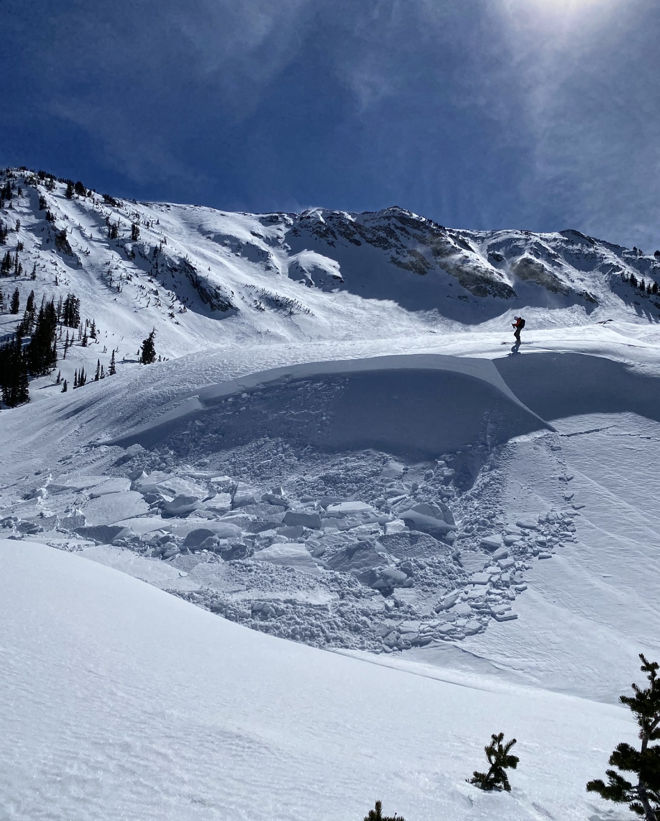
We are heartbroken to confirm that 51-year-old Micheal Janulaitis of Marion, Utah, was killed in an avalanche on March 7 near Hoyt Peak. Micheal was caught and carried while skiing a steep, northeast-facing run in Hoyt Bowl. We are deeply grateful to the teams who helped bring him home. Micheal was a friend of the UAC, and his loss is felt deeply in the backcountry community. He will be greatly missed.
We are compiling accident details and a preliminary report can be found HERE.
March kicks off our Spring Campaign! If everyone in Utah’s backcountry community donates the cost of something they regularly enjoy on an adventure—like a dawn patrol burrito, a backpack snack, or post-ride trailhead drinks—we could fund not just one but two forecasters for the entire season! Donate here. Thank you!
Weather and Snow
This morning, temperatures are in the mid to upper 20s °F at both trailheads and ridgelines, as most stations finally got below freezing last night. Winds are blowing from the south-southwest at 15-20 mph, with gusts a bit higher.
Today is the last day of false spring #1. We'll have mostly sunny skies and 10,000' high temps around 40°F. Unfortunately, strong winds blowing from the south are going to be the buzz killer with speeds in the 20's mph and gusts in the 40's mph, possibly higher in the most exposed terrain.
Outlook: Snow will begin falling in earnest tomorrow morning with the heaviest snow anticipated Thursday afternoon and evening with the passage of the cold front, causing a rapid fall in snow levels. Snow will continue
into Friday morning before diminishing. Forecast storm totals are about 17-25" of new snow by Friday morning. Gradual cooling should create right-side-up conditions.

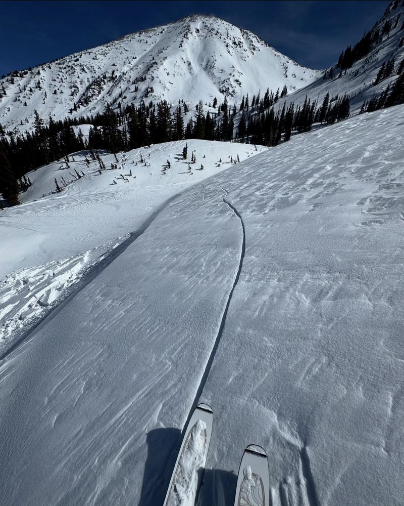
Snow Conditions: Very variable. A mix of wind crusts, melt-freeze crusts, some breakable, some not. Pockets of soft snow exist in N-facing terrain at mid and upper elevations. Everything else has been zapped by the sun. The likelihood of triggering a wet avalanche is decreasing, but don't be caught off guard in steep solar terrain in the heat of the day.
Recent Avalanches
Wet loose activity has diminished over the past day or two, but there is ample visual evidence of warmth-driven activity throughout the region. An avalanche of note occurred two days ago when Mark White remotely triggered a sizeable hard slab of wind-drifted snow near Red Baldy. This avalanche likely failed on buried near surface facets developed over recent clear nights.

Check out all avalanches and observations HERE.
Ad
Avalanche Problem #1
Wind Drifted Snow
Type
Location
Likelihood
Size
Description
Yesterday, we observed wind moving snow in all directions. Slopes were getting top-loaded, cross-loaded, and up-loaded in the most exposed terrain. With consistent strong winds forecast for today, expect to see slabs of wind-drifted snow forming near lee ridgelines and in and around terrain features like gullies, scoops, and rollovers. These may offer no signs of instability like cracking and could release once you are well out onto them.
Watch for and avoid signs of wind-drifted snow, such as textured or pillow-shaped features. Approach steep terrain cautiously, especially where drifting snow has accumulated.

Obvious signs of wind-drifted snow include texture, pillow-shaped features, and cracking as seen below. (pc:MW)
Avalanche Problem #2
Persistent Weak Layer
Type
Location
Likelihood
Size
Description
Two persistent weak layers remain a concern in the backcountry:
Upper Layer: Faceted snow under last week's storm, marked by a dirt layer. Several remotely triggered avalanches on this layer have occurred, including Red Baldy, Crystal Palace, and East Kessler-Catcher’s Mitt.
Deep Layer: Sugary, faceted snow from the holidays, now buried 2–4 feet deep. Avalanches here would be large and dangerous, especially on slopes with a thinner snowpack or that have already slid.
Recent field work shows improving stability, but both layers remain a concern. The only way to know if these layers are a concern is to get out your shovel and dig a pit.
General Announcements
This information does not apply to developed ski areas or highways where avalanche control is normally done. This forecast is from the U.S.D.A. Forest Service, which is solely responsible for its content. This forecast describes general avalanche conditions and local variations always occur.