UDOT PLANNED AVALANCHE CLOSURES!!

Forecast for the Salt Lake Area Mountains

Drew Hardesty
Issued by Drew Hardesty for
Monday, March 11, 2019
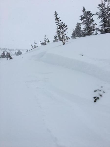
Localized areas of MODERATE danger still exist in the mid and upper elevations for recent storm snow instabilities. With any extended sun and heating today, the danger on the steep sunlit slopes will rise accordingly.
Safe and excellent powder riding can be found on low angle northerly slopes with no overhead hazard.
Low
Moderate
Considerable
High
Extreme
Learn how to read the forecast here
Special Announcements
Chapter 5 in the LOW Danger series has been published. It's the first of two first-hand accounts of the Blue Ice avalanche from January 5th. One can find all the chapters in the Blog page in the menu above.
Chapter 6 in the LOW Danger series is now published. It's the second of two first hand accounts of the Blue Ice avalanche from January 5th.
Thanks to these two. These stories need to be told.

Enjoy spring skiing at Snowbasin Resort. The UAC has discount Snowbasin tickets available. INFO
Weather and Snow
Skies are partly cloudy with temps in the upper teens to low 20s. The southeasterlies gusted into the teens and low twenties for a couple hours overnight but all stations are currently showing light wind.
Skiing and riding conditions remain excellent although some sunny aspects have a breakable melt-freeze crust beneath a few inches of snow.

For today, we should have varying degrees of cloud cover with light easterly winds. Mountain temperatures will rise to 20°F along the ridgelines with many base areas and trailheads pushing into the mid-30s. Clearing tonight and tomorrow ahead of a sharp cold front for Tuesday night into Wednesday. I think we can bank on 6-10", perhaps a touch more by late Wednesday. It'll be full-on spring conditions with a ridge of high pressure building for Friday into next week.
Recent Avalanches
Ski area control teams along the PC ridge triggered one storm snow avalanche a foot deep on a graupel layer on an east facing slope at 8800'. In the backcountry, a skier triggered a similar pocket in the Tri-Chutes of White Pine (LCC) on a steep west facing slope at 10,500' (pc Bollow). A party in Coalpit 4 of LCC found more uncertain graupel layering than they liked and bailed. Always a good thing to highlight good examples of measured and conservative decision making. All observations can be found in the Menu bar above.
Ad
Avalanche Problem #1
New Snow
Type
Location
Likelihood
Size
Description
It's becoming less likely, but you can still trigger an avalanche within the recent storm snow on a variety of structural interfaces up to and over two feet deep today. Failure planes may include graupel, early storm low density snow, and sun and rain crusts. Absent the tell-tale signs of instability (cracking, collapsing), it's worth pulling out the shovel and performing a few snow tests to gather info on the snow that you're keen to ski or ride. Use test slopes (steep but low consequence terrain) to help gather info for representative terrain.
A couple of fine points for today:
  1. Graupel (pellet snow) can be a significant weak layer as it often runs downhill and pools at the base of cliff bands or on clear transitions from steep to less steep terrain. It's not uncommon to successfully descend a couloir only to trigger the pocket in the aprons or more benign terrain below.
  2. Sluffing today is possible in the steepest terrain and may be more likely and problematic on the steep southerly aspects today. Weak snow may have developed above Saturday's sun crusts and this may aid and abet any of the sluffing on these slopes.
  3. Cornices are generally too large to tangle with and remain highly suspect. Remember 5% of our avalanche fatalities involve cornice fall.
Avalanche Problem #2
Wet Snow
Type
Location
Likelihood
Size
Description
Ah, spring. Where cloud cover and weather can turn on a dime. With significant sun and/or greenhousing, wet loose avalanches may be expected. This sort of thing can be hard to forecast, but easy to nowcast: if you're feeling hot and/or damp and humid, the snow feels the same - look for rollerballs, natural wet sluffs, and unsupportable snow.
KEY POINT: cold dry snow that sees sun/heating for the first time is almost always unstable in the spring - pay attention to what's going on around you.
General Announcements
This information does not apply to developed ski areas or highways where avalanche control is normally done. This forecast is from the U.S.D.A. Forest Service, which is solely responsible for its content. This forecast describes general avalanche conditions and local variations always occur.