UDOT PLANNED AVALANCHE CLOSURES!!

Forecast for the Salt Lake Area Mountains

Drew Hardesty
Issued by Drew Hardesty for
Sunday, March 10, 2019
A MODERATE DANGER exists for human triggered avalanches 1-2'+ deep and a couple hundred feet wide on a variety of aspects and elevations...and pockety in the lower elevations. Loose snow sluffs may run fast and far, especially on the steepest southerly aspects.
Safe and excellent powder riding can be found on low angle northerly slopes with no overhead hazard.
Low
Moderate
Considerable
High
Extreme
Learn how to read the forecast here
Special Announcements
Greg’s Week in Review has arrived! Check it out here.

Chapter 5 in the LOW Danger series has been published. It's the first of two first-hand accounts of the Blue Ice avalanche from January 5th. One can find all the chapters in the Blog page in the menu above.
Weather and Snow
Happy Daylight Savings.
Skies are overcast with light snow falling in the mountains. Under the spell of a weak warm front, most areas have picked up a 1-4" (5-6% density) overnight with slowly warming temperatures (mid-teens) and mercifully light winds from the south. The cool, shady terrain will still have 5 star riding but some southerlies will have a breakable sun crust beneath the new.
Total storm snow since March 5th:
Upper LCC: 29"-35" snow (2.53"-2.95" h20) Total snow depths are 140-160"
Upper BCC: 31"-38" snow (2.48"-3.46" h20) Snow depths are 130-150"
Park City Ridge: 17.5"-20" snow (0.65"- 2.0" h20) Snow depths are 80-120"
It's been a good run this winter with much of the state well above average- see below (courtesy of our partners here at the Colorado Basin River Forecast Center - we share an office with them at the NWS)

For the next couple days, we can expect overcast to mostly cloudy skies, light southerly winds and a warming trend toward the upper 20s along the ridgelines. A weak storm system arrives Tuesday night into Wednesday which should be good for another 4-8" of snow. Get it while you can. Models suggest high and dry late week into the weekend...and beyond -
Recent Avalanches
Ski area avalanche control teams triggered both shallow storm slabs and loose snow avalanches with ski cuts and explosives.
In the backcountry, reported avalanches include the following:
  • Skiers walking the West Willow ridgeline remotely triggered the West Willow pocket 2' deep and 300' wide. This path is at 9600' on a northeast facing slope. (pc Agardy)
  • An intentional cornice drop in South Monitor triggered a 12" deep and 40' wide pocket. This was at 9800' and northeast facing. (good write up here)
  • In Snake Creek on the Wasatch backside, a snowmobiler on a test slope triggered a 18" deep soft slab avalanche on an east facing slope at 8000'. Another similar slide also triggered adjacent to this pocket.
Confused on locations? Steve Achelis (long time UAC board member) has a great map and web page and app. Wasatch Backcountry Skiing. They're great.
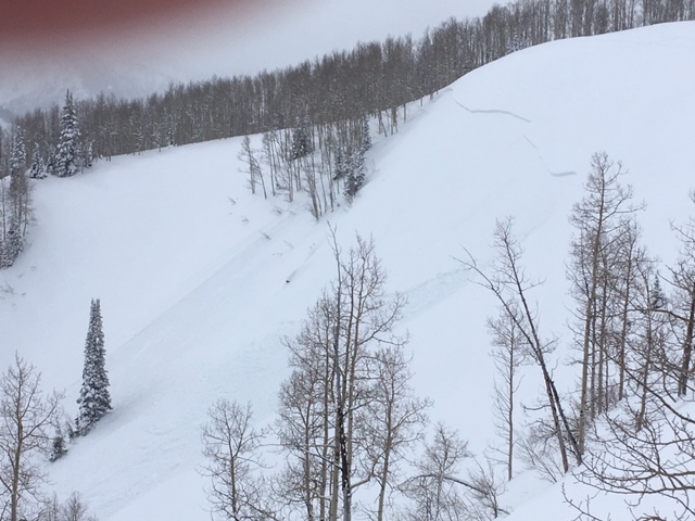
 INFO
Mark White has an excellent photo of a typical graupel-pooling slab avalanche in upper Cardiff Fork that likely occurred Friday. More on this below -
Ad
Avalanche Problem #1
New Snow
Type
Location
Likelihood
Size
Description
You can still trigger an avalanche within the recent storm snow on a variety of structural interfaces up to and over two feet deep today. Failure planes may include graupel, early storm low density snow, and on sun and rain crusts. Absent the tell-tale signs of instability (cracking, collapsing), it's worth pulling out the shovel and performing a few snow tests to gather info on the snow that you're keen to ski or ride. Use test slopes (steep but low consequence terrain) to help gather info for representative terrain.
A couple of fine points for today:
  1. Graupel (pellet snow) can be a significant weak layer as it often runs downhill and pools at the base of cliff bands or on clear transitions from steep to less steep terrain. It's not uncommon to successfully descend a couloir only to trigger the pocket in the aprons or more benign terrain below.
  2. Sluffing today is possible in the steepest terrain and may be more likely and problematic on the steep southerly aspects today. Weak snow may have developed above yesterday's sun crusts and this may aid and abet any of the sluffing on these slopes.
  3. Cornices are generally too large to tangle with and remain highly suspect. Remember 5% of our avalanche fatalities involve cornice fall.
Additional Information
FORECASTER'S CORNER:
  1. Terrain and terrain traps: note that some terrain is forgiving (nice open runout zones) and some is not. This must be part of the calculus if the snow doesn't agree with your assessment of it. Will you get carried over a cliffband, buried more deeply in a gulley or slope transition, or bashed through the trees? Use terrain to your advantage.
  2. Don't let the feeding frenzy go to your head. Communicate with other parties that may be above or below. One of Colorado's avalanche fatalities this winter involved a skier triggered avalanche onto a person in the runout zone below. INFO
General Announcements
This information does not apply to developed ski areas or highways where avalanche control is normally done. This forecast is from the U.S.D.A. Forest Service, which is solely responsible for its content. This forecast describes general avalanche conditions and local variations always occur.