Donate to the 2024 Spring Campaign to help rebuild the UAC website.

Forecast for the Salt Lake Area Mountains

Evelyn Lees
Issued by Evelyn Lees for
Thursday, February 28, 2019
There is a MODERATE avalanche danger on upper elevation slopes where one of the scattered, hard wind drifts can be triggered. At mid and low elevations the danger is LOW, though it's possible to trigger an isolated wind drift or push a wet loose sluff, especially if it rains where you are.
Low
Moderate
Considerable
High
Extreme
Learn how to read the forecast here
Special Announcements
Enjoy spring skiing at Snowbasin Resort. The UAC has discount Snowbasin tickets available.
Are you new to the backcountry or looking to refresh your skills? The UAC has released a free 5-part avalanche skills eLearning series.
The latest podcast with Ian McCammon has been published. Check it out HERE.
Weather and Snow
This morning, under mostly cloudy skies, temperatures are below freezing, in the mid to upper twenties. It’s going to be another warm, humid day with cloudy skies and temperatures warming to near 40 at 8,500’ and near 30 at 10,000’.
Yesterday, most locations picked up 1 to 2” of dense snow above about 8,000’. Another trace to 2” of snow is possible this afternoon, with the rain/snow line between 6,500 and 7,000’.
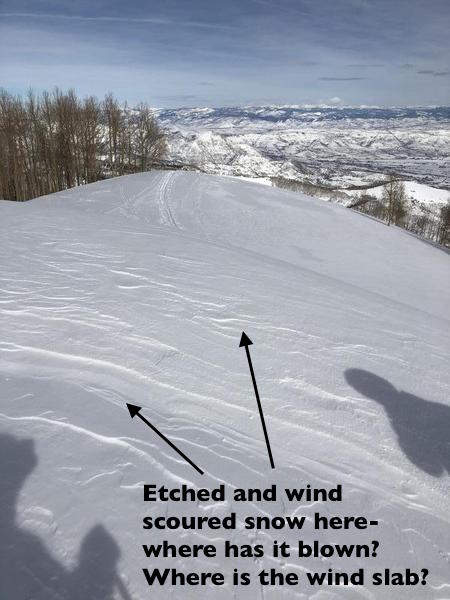
There will be a bit of a break from the recent strong southwesterly winds, with 10 to 20 mph averages at 9 and 10,000’, and only the 11,000’ peaks averaging to 30 mph at times, gusting to 40.
Isolated patches of soft dense powder can be found on wind sheltered mid and upper elevation slopes. The snow at the lower elevations is an inconsistent mix of mashed potatoes and crusts.
Overnight, the mountains could get 3 to 5” of snow as a weak cold front moves through. This will be followed by small disturbances adding 1 to 3” every 12 hours, which could add up to a nice refresh of dense snow at the mid and upper elevations.
Recent Avalanches
There was one collapse reported on a north facing, mid elevation slope in Big Cottonwood and observations of the wind still drifting and loading snow along ridge lines.
Close by in the Ogden area mountains, resorts have been able to pry out isolated, stubborn hard wind drifts over the past few days, including one that was skier triggered.
Ad
Avalanche Problem #1
Wind Drifted Snow
Type
Location
Likelihood
Size
Description
Avoiding the hard, "stubborn" slabs of wind drifted snow that are scattered at the upper elevations is the main avalanche issue today. These wind drifts are most widespread on north and northeasterly facing slopes, but can be found cross loading onto other aspects. “Stubborn” wind drifts are dense or hard and tend to break out above you when you’re a couple turns down the slope or break on the second or third person on a slope.
The best way to avoid these wind slabs is to look for them. Wind drifts are often rounded, smooth, and could feel hard and hollow. Cracking in the snow is a sign of a wind drift. If you see a slope that’s been scoured or eroded, think about where the snow may have been deposited.
The large cornices have become a permanent part of the landscape, and may be a bit more sensitive with the warmer temperatures. They will break back much further than expected - avoid travel below and on these.
American Fork Canyon, photo by Porter.
Avalanche Problem #2
Wet Snow
Type
Location
Likelihood
Size
Description
Temperatures are cooler this morning, but forecast to warm to well above freezing again at the low and mid elevations, with the rain/snow line as high as 7,000’ at times. As the day warms or if it rains significantly where you are, expect to trigger wet loose sluffs in mushy, unconsolidated snow on steep slopes.
General Announcements
This information does not apply to developed ski areas or highways where avalanche control is normally done. This forecast is from the U.S.D.A. Forest Service, which is solely responsible for its content. This forecast describes general avalanche conditions and local variations always occur.