Forecast for the Salt Lake Area Mountains

Dave Kelly
Issued by Dave Kelly on
Monday morning, February 24, 2025
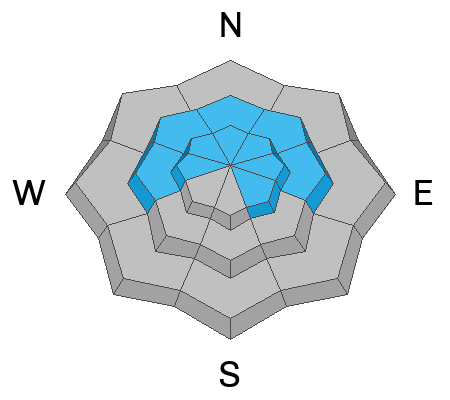
The avalanche danger is CONSIDERABLE where it is likely that a human will trigger an avalanche that fails on a layer of buried facets or on a new/old snow interface up to 2' deep on west-north-east facing mid and upper elevation terrain and on upper elevation southeast facing slopes.
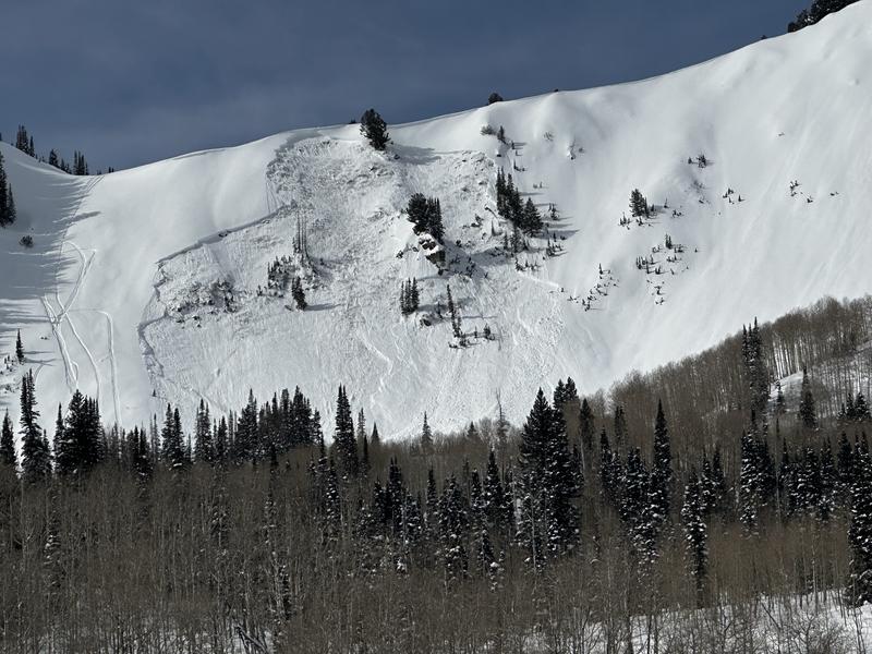
The avalanche danger will rise to CONSIDERABLE in mid and lower elevation terrain on all aspects where natural wet snow avalanches are possible. Stay off of and out from underneath steep terrain especially later in the afternoon.
Lower angle shaded meadows are the best place to find soft turns and stay out of avalanche terrain right now. Start and finish early to avoid the wet snow problem.
Low
Moderate
Considerable
High
Extreme
Learn how to read the forecast here
Weather and Snow
Currently, under partly cloudy skies trailhead temperatures are in the mid to high 30's °F. The highest elevations are in the high 20's °F. Winds are blowing from the west-northwest in the teen's gusting to the 20's MPH at the lower ridgelines and from the west in the 30's gusting to the 50's at the highest ridgelines. There was a trace of new snow last night in some mountain locations.
Today, look for partly cloudy skies with high clouds. Temperatures in the mid-to-high 40's °F and winds blowing from the west-southwest 10 gusting to 20 MPH at the lower ridgelines and from the west-northwest 35 gusting to 50 MPH at the highest ridgelines. There is a chance of precipitation today with a freezing level hovering around 9,000' and rising through the afternoon hours.

The snow surface is worn out on many south facing aspects where you'll find a mix of crusts, damp heat affected snow in the lower elevations or wind-affected snow in the mid and higher elevation terrain. There are still soft turns to be had in protected areas out of the wind zone.
Recent Avalanches
Yesterday, we had reports of greenhousing, rollerballs and a warming snow surface in lower elevation terrain. There were reports of collapsing in mid-elevation terrain and this is a sign that the snow pack is still settling out. If you hear or feel signs of collapsing then back off of steep terrain. Observers reported damp snow below 8,500' in elevation and surprisingly warm temperatures throughout the range. Check out all observations and avalanches HERE.
UAC Forecasters went to look at the site of a near miss on Mt Aire that occurred on Saturday, February 22, and found an avalanche that ran 1400' failing on a layer of broken precipitation particles. Read the full observation HERE.
Ad
Avalanche Problem #1
Persistent Weak Layer
Type
Location
Likelihood
Size
Description
A variety of persistent weak layers are still being found on mid-elevation and upper elevation west-north-east facing slopes and on upper elevation southeast facing aspects. These buried weak layers are variable and make for a complex problem. Thinner, rockier spots, and areas that avalanched earlier in the season are more likely to be places where you could trigger an avalanche failing on a buried layer of facets. This is most likely what we saw on this east facing slope (9,600') on Ant Knolls in the Northern Provo Region on Saturday, February 22. There are also avalanches being triggered within the new/old snow interface that are reacting more like a persistent weak layer avalanche in the mid-elevations and in some cases the only way to identify this weak layer is to get your shovel out, dig, and perform some sort of stability test.
The last avalanches failing on a layer of weak buried facets in low elevation north facing terrain was on Thursday, February 20th in Summit Park, and on the southerly facing slopes the last reported persistent weak layer avalanche was in Little Cottonwood Canyon on Friday, February 21, 2025. While we have removed the persistent weak layer problem from the lower elevation terrain there is still a chance of an isolated human triggered avalanche failing into buried facets near the ground. If you hear any signs of collapsing at any elevation or aspect then find a lower angle slope to travel on or underneath.
We are not done with this buried persistent weak layer quite yet and as much as the mindset in late February typically turns to open-season, it's not that type of season. Give this snowpack some time to settle into its spring coat.
Photo (Shea) of a human triggered avalanche on Ant Knolls
Avalanche Problem #2
Wet Snow
Type
Location
Likelihood
Size
Description
Many stations up to 9,000' have not had a refreeze since yesterday morning. The snowpack in the mid and lower elevation terrain out of the wind zone may be saturated and the chance of triggering a gouging wet snow avalanche will increase with warming temperatures. Areas with long run out zones where avalanches could start as dry snow avalanches and turn into wet snow avalanches may overrun the snow line and even people not traveling in starting zones could be susceptible to avalanches. Avoid being underneath avalanche terrain on mid and lower elevation slopes, particularly during the heat of the day.
Avalanche Problem #3
Wind Drifted Snow
Type
Location
Likelihood
Size
Description
With increased wind speeds overnight, there will be drifting snow in mid and higher elevation terrain. Look for and avoid slopes with overhanging cornices and pillowy areas of shiny snow. If you see signs such as cracking and collapsing within the wind-drifted snow then you may be able to trigger avalanches in steep terrain (greater than 30°). Any slope involving wind-drifted snow on a buried layer of facets will be deeper and more likely to bury a human.
General Announcements
This information does not apply to developed ski areas or highways where avalanche control is normally done. This forecast is from the U.S.D.A. Forest Service, which is solely responsible for its content. This forecast describes general avalanche conditions and local variations always occur.