Join us for the 17th Annual Professional Snow and Avalanche Workshop (PROSAW) on November 4 - Purchase tickets here!

Forecast for the Salt Lake Area Mountains

Nikki Champion
Issued by Nikki Champion on
Thursday morning, February 24, 2022
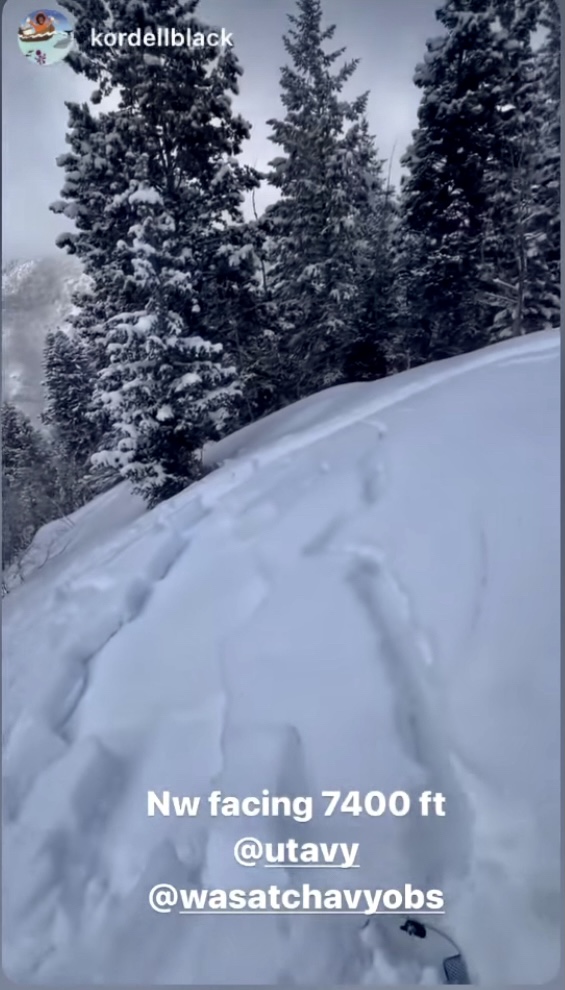
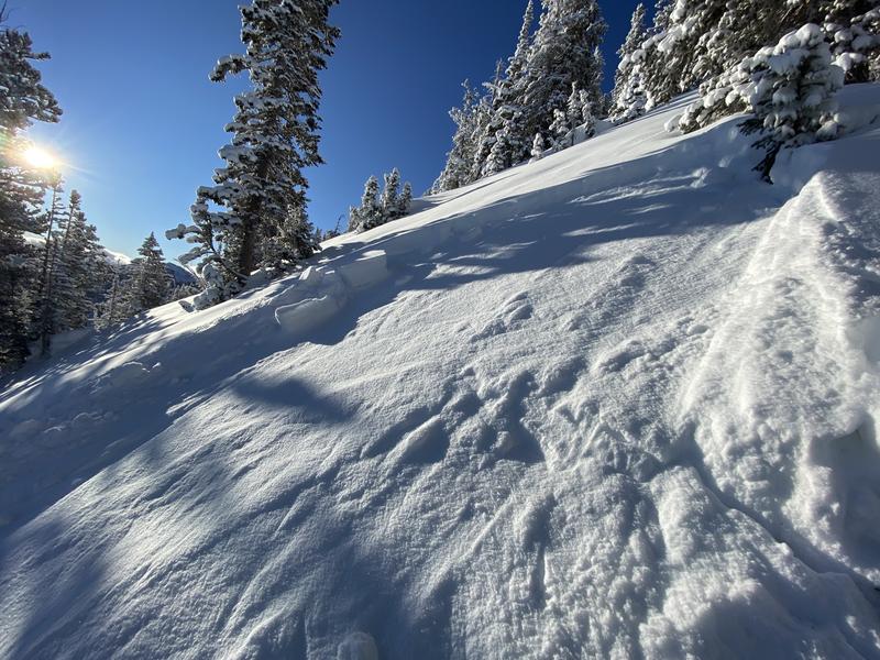
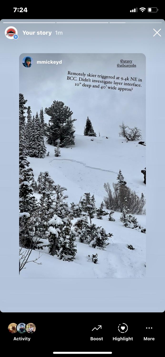
Today, we have a CONSIDERABLE avalanche danger on all steep mid and upper elevation slopes facing west through north through east where fresh wind drifts and new snow sit atop of the weak faceted snow. These types of avalanches are what we call unmanageable as you can trigger them from a distance. These are prime accident conditions.
A MODERATE danger exists for all other freshly wind-loaded slopes.
The remaining aspects and elevations have a LOW danger.
Low
Moderate
Considerable
High
Extreme
Learn how to read the forecast here
Weather and Snow
This morning, skies are clear and it has stopped snowing. The central Wasatch picked up a trace amount of snow (0-0.05" SWE) overnight, pushing rough storm totals to 7-13"/.65-1.13"SWE. Mountain temperatures are hovering below 0°F this morning, with upper elevation ridgeline temperatures sitting near -7 °F. The winds have begun backing off and transitioning from Northwest to Westerly. Winds are currently blowing 5-15 mph with gusts near 30 mph at the highest ridgelines.
Today, skies will become mostly cloudy with a slight chance of snow showers through mid-morning. Temperatures will rise into the low teens °F, and the westerly winds will remain light, blowing 5-15 mph at mid-elevations, and 15-25 mph at upper elevations. The highest gusts at upper elevation ridgelines could reach 40 mph.

This evening, another cold trough will drop into the area bringing periods of snowfall after midnight. The weather is looking clear and warm for the weekend.
Recent Avalanches
Yesterday, there was one new avalanche reported in Neff's Canyon on an NW Aspect at 7400'. This avalanche was reported on Instagram, so there is not a full observation, but it appears to have failed down 10-12" on the new snow/old snow interface.

I think yesterday's cold temperatures and stormy weather contributed to a lower number of observations from the backcountry. On Tuesday, we had three avalanches reported in the backcountry that failed on the new snow/old snow interface. In other words, we had *just* enough new snow and *just* enough wind to start to develop a slab over our widely advertised Jan/Feb drought layer. Since Tuesday we've added more snow and more wind.
Kessler Peak of BCC: 9600' NE facing. A skier collapsed the slope and triggered a 12" deep and 20' wide pocket while ascending the Patterson ridge and was nearly caught in the slide (1st photo)
Broads Fork of BCC: 9400' NE facing A skier remotely triggered a 10" deep and 40' wide from 15' away (2nd photo)
Mill B South of BCC: 8500' East facing A skier unintentionally triggered an 18" deep and 20' wide pocket in steep rocky terrain
Ad
Avalanche Problem #1
Persistent Weak Layer
Type
Location
Likelihood
Size
Description
These are prime conditions for backcountry accidents and close calls...
Over the past few days, we have begun seeing soft slab avalanches failing on a persistent weak layer (the Jan/Feb drought layer of facets) on the Northern end of the compass. With every bump in wind speed and/or new snowfall event added to our fragile snowpack, we continue to wait for the weak facets from the past two months to become unglued. While we have yet to see things become fully unglued, we have begun seeing avalanches failing 10-18" down, within that layer, and know that human triggered avalanches will continue to be possible today.
Given the new snowfall, elevated winds, and poor snowpack structure I would avoid any west through north through east facing terrain steeper than 30 degrees, with any steep terrain above or attached to it. Today is not the day to push it. This persistent weak layer is not going anywhere fast, and these avalanches will be tricky, unusual, dangerous, and widely variable....as the snowpack has become widely variable over the past two months. Currently, the best way to handle it is avoidance. Stick to low-angle terrain today.
The good news: With this past week's new snowfall, the riding conditions have greatly improved on all aspects. So if you are going out today, slope angle and aspect are going to be the name of the game.
Avalanche Problem #2
Wind Drifted Snow
Type
Location
Likelihood
Size
Description
The new low-density snow combined with a few days of elevated winds will have created some soft slabs of wind drifted snow at upper elevations, and even some mid-elevation terrain features such as sub-ridges and gullies. These wind slabs will be shallow and overall small in size, but these new wind drifts are sitting atop weak faceted snow or a firm snow surface, which will make them very sensitive and cause them to run far and fast. Even a small avalanche would be enough to knock a person off their feet and through complex terrain. Look for any obvious signs of wind drifted snow, such as hollow sounding or pillow-shaped snow, and avoid those slopes.
Elevated winds can deposit snow on all aspects but give west through north through east extra caution, as triggering an avalanche that initially fails in the wind-drifted snow is most suspect to step down deeper and fail into the weak faceted from January and February.

In any wind-sheltered areas, some new soft snow may still be found. In those areas, you may find still find some lingering fast-running sluffs or sensitive storm slabs. Look for signs of new snow instabilities such as cracking, and collapsing.
General Announcements
Who's up for some free avalanche training? Get a refresher, become better prepared for an upcoming avalanche class, or just boost your skills. Go to https://learn.kbyg.org/ and scroll down to Step 2 for a series of interactive online avalanche courses produced by the UAC.
This information does not apply to developed ski areas or highways where avalanche control is normally done. This forecast is from the U.S.D.A. Forest Service, which is solely responsible for its content. This forecast describes general avalanche conditions and local variations always occur.