Join us for the 17th Annual Professional Snow and Avalanche Workshop (PROSAW) on November 4 - Purchase tickets here!

Forecast for the Salt Lake Area Mountains

Drew Hardesty
Issued by Drew Hardesty on
Sunday morning, February 24, 2019
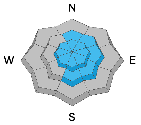
Today's danger is MODERATE for recent and developing wind drifts in the mid- and upper-elevations. The drifts will be most pronounced on steep north to east to south facing slopes above about 9500', with more isolated drifts on other aspects and in the mid elevations. Dry sluffing remains a possibility, especially in the steepest, most confined terrain. Wind sheltered terrain has a generally LOW danger and still holds some incredible skiing and riding conditions.
Low
Moderate
Considerable
High
Extreme
Learn how to read the forecast here
Special Announcements
New Blog post - Low Danger - Chapter 1 - We're All in This Together
New Blog-cast - I AM Dangerous

Catch up on the past week of snow, weather and avalanches with Greg Gagne’s Week in Review.
Weather and Snow
Today's forecast written by Benjamin Bombard and approved by Drew Hardesty.

Another beautiful morning in the Wasatch. Periods of sunshine today between the cloud cover as a moist westerly flow builds to the north of the Wasatch. That newly arriving storm system could pack a wintry punch tomorrow for the Ogden and Logan area mountains, with a 4-8"+ or more of new snow possible by tomorrow afternoon.
Mountain temperatures are in the single digits and warming slowly into the low- to mid-teens. We may even see temps reaching into the 20s today in the Cottonwoods.
The wind is swirling out of the west, blowing between 15-25mph, with gusts into the 30s and reaching to the 40s as the new system approaches.
No new snow to report, with depths sitting between 110" and roughly 130" in the upper Cottonwoods, between 75" and 100" along the Park City ridgelines. We'll probably see light snow accumulations in the Wasatch beginning tonight and falling slowly and intermittently in the coming days. I think we can say with certainty that the groundhog missed his forecast!
Skiing and riding conditions are excellent, especially in wind-sheltered and northern aspects, where the snow is deep and dry.
Recent Avalanches
Small wind slabs, a cornice fall and a handful of dry sluffs reported form the backcountry yesterday, in steep terrain in Little Cottonwood and along the Park City ridgeline.
Ad
Avalanche Problem #1
Wind Drifted Snow
Type
Location
Likelihood
Size
Description
There remains the potential for wind drifts, up to a foot deep, in the higher elevations today. Cold temps have preserved the low density snow and it will be pushed around by the strengthening westerly winds today. These drifts may be up to a foot deep and more pronounced on steep north to east to south facing slopes above 9500'. Some crossloading noted on westerly terrain in the upper elevations yesterday. Due to terrain channeling, pockety drifts may be found in the mid-elevations of all aspects. Take note that it may be possible for some drifts to be triggered remotely (at a distance).
Additional Information
There is a very isolated chance a person, cornice or smaller slide could trigger a slide breaking on facets near the ground, in thinner snowpack areas or slopes that have previously slid this winter.
General Announcements
This information does not apply to developed ski areas or highways where avalanche control is normally done. This forecast is from the U.S.D.A. Forest Service, which is solely responsible for its content. This forecast describes general avalanche conditions and local variations always occur.