Forecast for the Salt Lake Area Mountains

Nikki Champion
Issued by Nikki Champion for
Saturday, February 17, 2024
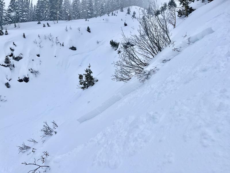
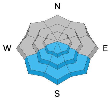
The avalanche danger is CONSIDERABLE on slopes facing west through north through east across the upper elevations, where moderate to strong winds have created sensitive slabs of wind-drifted snow, and it remains possible to trigger a hard slab avalanche breaking 4-6 feet deep on a deeply buried persistent weak layer of faceted snow. The mid-elevation slopes that received generally less wind and snow have a MODERATE danger.
The danger will rise to MODERATE on the solar slopes as the new snow heats up. Remember, even "smaller" slides can be dangerous in high-consequence terrain. Rollerballs are the first sign that the snow surface is becoming wet, and it might be time to switch aspects.
Careful snowpack evaluation, cautious route-finding, and conservative decision-making will be essential today.
Low
Moderate
Considerable
High
Extreme
Learn how to read the forecast here
Special Announcements
We are seeking a passionate individual to join us as Executive Director of the nonprofit Utah Avalanche Center. Click here for more information.
Weather and Snow
This morning, skies are clear, and temperatures range from the single digits to low teens°F. Winds are primarily from the east and southeast, blowing at 5-10 mph, with gusts up to 20 mph. Winds have been progressively decreasing since yesterday afternoon and evening, with some overnight gusts reaching up to 60 mph. Snowfall tapered off around 9 PM.
Snow totals since Wednesday:
Cottonwoods: 18-35" containing 1.5-2.26" of SWE (Snow Water Equivalent).
Park City Ridgeline: 12-18" containing 0.75-1.0" of SWE (Snow Water Equivalent).
Today should be a beautiful day in the mountains, with temperatures rising into the upper 20s and low 30s°F. Winds will shift more to the southeasterly direction and remain light. High clouds may begin to build over the area by late afternoon, but overall, it should be a sunny day.
Extended: The next system should begin after midnight tonight, bringing another 3-7" of snowfall by Sunday morning. Snow on Sunday morning will turn to showers by the afternoon. After a break Sunday night into Monday morning, expect intermittent snow chances from late Monday to early Thursday, with the main snowfall expected on Wednesday.
Recent Avalanches
Several more avalanches were reported in the backcountry on Friday. Avalanches have been occurring on aspects facing west through north to southeast, ranging from 6 inches to 2 feet deep and up to 150 feet wide. These avalanches occurred within a density inversion in the storm snow or at the interface with the old snow surface, particularly on solar aspects that had previously been exposed to sunlight. These areas now have a firm melt-freeze crust with weak stellars or faceted grains at the interface between the new and old snow. An example is provided below of a 14-inch deep and approximately 45-foot wide avalanche on a southeast aspect at 8,500 feet elevation from Grainger, Young, and Olafsen in Day's Fork.
On Thursday, one Cottonwood resort reported a natural avalanche that broke into old, faceted snow on a northwest aspect at 10,600 feet.
All recent reported avalanche activity.
Ad
Avalanche Problem #1
Wind Drifted Snow
Type
Location
Likelihood
Size
Description
With moderate to strong winds over the past 24 hours and plenty of fresh snow, sensitive slabs of wind-drifted snow are likely to be encountered on all upper-elevation slopes and mid-elevation terrain features that allow for drifting snow accumulation. These drifts could be 6-24 inches deep and up to 100 feet wide. Watch out for signs of wind-drifted snow, such as pillow-shaped deposits, and avoid those slopes.

Outside of the wind zone, the new snow will still be reactive. Instabilities could occur at the interface with the old snow surface or within storm snow itself.
Any avalanches, wind-drifted snow, or the new snow may travel fast and far due to weak grains at the new snow, old snow interface. The Valentine's Day storm buried facets, weak stellars, and surface hoar on many slopes. Yesterday, Drew headed to 10,420' to investigate this layer and found weak snow on almost all aspects. While this layering was noticeable on north-facing slopes, there was no observed cracking or collapsing. On east-facing slopes, collapsing was obvious and primarily occurred on facets and small-diameter surface hoar associated with a buried 2cm melt-freeze crust. It's expected that this layering will settle in a few days but could remain active under any stress, whether from wind or snow. Due to this weak interface, remote triggering an avalanche from a distance remains possible.
Avalanche Problem #2
Persistent Weak Layer
Type
Location
Likelihood
Size
Description
The Persistent Weak Layer (PWL) avalanche problem is moving in the right direction as more snow is added to the snowpack, and the weak layer continues to gain strength. However, Thursday's avalanche into old, faceted snow at a Cottonwood resort indicates that the problem still exists in isolated areas. If an avalanche were to be triggered in the PWL, it would be 4-6 feet deep and well over a hundred feet wide.
Due to the uncertainty and the potential size of avalanches failing in the PWL, I will continue to avoid steep, northerly slopes at mid and upper elevations.
Avalanche Problem #3
Wet Snow
Type
Location
Likelihood
Size
Description
With today's clear skies and warm temperatures, the bright Utah sun will cause the cold snow to start shedding on solar-facing aspects (southeast-south-west). Watch for snow falling off rocks and avoid steep gully features as the day warms up. Move away from steep slopes when the snow gets wet and shows signs like rollerballs, wet sluffs, or cornice breaks. Plan a safe exit route back to your car.
Rooflines still holding snow may start shedding today. Be aware of children playing or adults shoveling solo or working around the house, as they are the most vulnerable to roof slides.
General Announcements
This information does not apply to developed ski areas or highways where avalanche control is normally done. This forecast is from the U.S.D.A. Forest Service, which is solely responsible for its content. This forecast describes general avalanche conditions and local variations always occur.