Forecast for the Salt Lake Area Mountains

Dave Kelly
Issued by Dave Kelly for
Tuesday, February 13, 2024
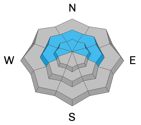
Today, the avalanche danger is CONSIDERABLE on upper elevation slopes facing northwest through east where you may trigger a deep slab avalanche breaking 4-6' deep on buried facets. Thoughtful travel and careful snowpack evaluation will get you to the safest conditions.
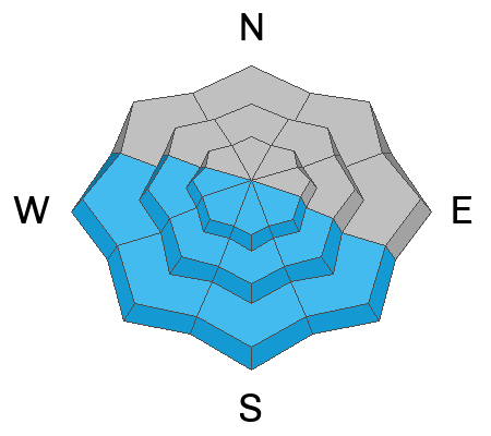
On all other slopes, the avalanche danger is MODERATE where it will be possible to trigger either a wet loose avalanche with solar warming throughout the day; or a wind-drifted snow avalanche near ridgetops.
Low
Moderate
Considerable
High
Extreme
Learn how to read the forecast here
Weather and Snow
This morning, under clear skies temperatures are in the mid-teens °F. Winds are blowing from a westerly direction 10 gusting to 15 MPH at the 9,000' ridgelines and 20 gusting to 25 MPH at the highest ridgelines. There was no new snow overnight and cold clear conditions led to faceting of the surface snow.
For today, look for clear skies with temperatures from 35-38°F. Winds will blow from a westerly direction 15 gusting to 20 MPH at the 9,000' ridgelines and 20 gusting to 30 MPH at the 11,000' ridgelines. No new snow is forecast for today.
Yesterday there were reports of dry loose avalanches running in the surface snow and of wind-drifted snow isolated to the ridgelines. Cornices are a sign that the slope below has been wind-loaded and in some cases the combination of wind-drifted snow and the buried facets could make for large avalanches that would be unsurvivable if you were to be involved (Read about a very close call involving wind-drifted snow in Lisa Falls from Sunday HERE). Cold temperatures over the last week have maintained great travel conditions and there is still great riding on shady aspects less than 30 °.
Recent Avalanches
This was an active avalanche weekend in the backcountry. Some stand out avalanches are listed below:
  • Skier triggered-Broads Fork Twins-Lisa Falls 11,200 Southeast Aspect- Wind-drifted snow avalanche 2' deep - ran 1500' vertical- 1 caught and carried Helicopter Evacuation
  • Unknown trigger-Main Gobblers - Millcreek Canyon - 9800' - Northwest Aspect - Hard slab failing on facets 5' deep - 400' wide - ran 2000' vertical
  • Skier triggered-Cardiac Ridge - Cardiff Fork - 10,800' - East Aspect - Hard slab failing on facets 3.5-4' deep - 350' wide-ran 1000' vertical 1 caught and carried
  • Snowboarder triggered-Pioneer Ridge- Toilet Bowl- 10,200'- North Aspect- Hard slab failing on facets 3' deep-70' wide-ran 200' vertical 1 caught and carried
  • Skier Triggered-Pole Canyon- 10,000'-West Aspect-Soft slab failing on a graupel 3' deep 30' wide-ran 350' vertical 2 caught and carried

Read all the observations HERE.
Ad
Avalanche Problem #1
Persistent Weak Layer
Type
Location
Likelihood
Size
Description
This avalanche problem remains a concern, particularly in the most suspect areas; steep, shallow, and rocky terrain features, or shallow areas that have previously avalanched this the season. As the avalanche danger decreases and the snow settles out after last week's storm there is still a chance of triggering a deeper avalanche breaking down into dry facets buried 4-6' deep. These avalanches may be hundreds of feet wide and run 1000'-2000' vertical feet as we saw on Gobblers this weekend (See video below).
The avalanche rose below shows us the avalanche activity distribution by aspect and elevation over the last week on the buried persistent weak layer. There were 8 avalanches triggered on these buried facets in the Salt Lake Region over the last week.
Avalanche Problem #2
Wet Snow
Type
Location
Likelihood
Size
Description
With today's warm temperatures and the bright Utah sun solar facing aspects (southeast-south-west) will start to shed snow. Watch for snow falling off rocks and stay out of steep gully features as the day warms up. Roof-lines that are still holding snow may start to shed today. Be aware of children playing or adults shoveling solo or working around the house as they are the most vulnerable to roof slides.
Additional Information
Check out this video that the UAC put together looking at the recent avalanche in Main Gobblers.
General Announcements
This information does not apply to developed ski areas or highways where avalanche control is normally done. This forecast is from the U.S.D.A. Forest Service, which is solely responsible for its content. This forecast describes general avalanche conditions and local variations always occur.