Forecast for the Salt Lake Area Mountains

Drew Hardesty
Issued by Drew Hardesty for
Thursday, February 10, 2022
The snowpack is generally stable and the avalanche danger is LOW. Watch for (1) isolated pockets of wind-drifted snow in exposed terrain at the upper elevations, and (2) minor sluffing in the snow in steep northerly terrain.

Remember that RISK is inherent in mountain travel; getting caught in even a small avalanche could have serious consequences in steep, rocky terrain.
Low
Moderate
Considerable
High
Extreme
Learn how to read the forecast here
Special Announcements
Join the Utah Avalanche Center on Saturday, February 12th at the Brighton Beacon Bash hosted by Weston Backcountry, Utah Mountain Adventures, Black Diamond, and Ortovox. There will be FREE ski and splitboard demos, avalanche rescue gear demos and a LIVE mock avalanche rescue.
Weather and Snow
In his memoir, long time Little Cottonwood avalanche professional Liam Fitzgerald writes a chapter on the constellation Orion. Initially signaling the approach of winter and then clearly dominating the night sky, Orion brought for Liam a feeling of uneasiness and sometimes dread. As it's been mostly dry with clear night skies since New Year's, I can say we've been seeing a little too much of The Hunter these days. We can only hope he becomes obscured by storms and clouds in the near future.

Skies are mostly clear this morning with mountain temperatures in the mid-20s. As of 5am, the increasing north-northwest winds are 15-20mph except along the 11,000' ridgelines where they're seeing hourly averages of 20-30mph with gusts to 45.
For today, we'll have sunny skies, temperatures warming into the mid to upper 30s, and increasing northwest winds.
At this point, the weather models depict the breakdown of the ridge early next week with a Pacific storm moving in from the northwest. There are hints that the storm may split, leaving us with only a couple inches of snow, but we'll give it a couple more days to see how things play out.

Thanks to stormy October and Decembers, coverage remains good and winter backcountry travel is easy. Wind and sun crusts abound, but softening corn-like conditions exist on solar aspects and a few soft turns can be found in sheltered northerly terrain.
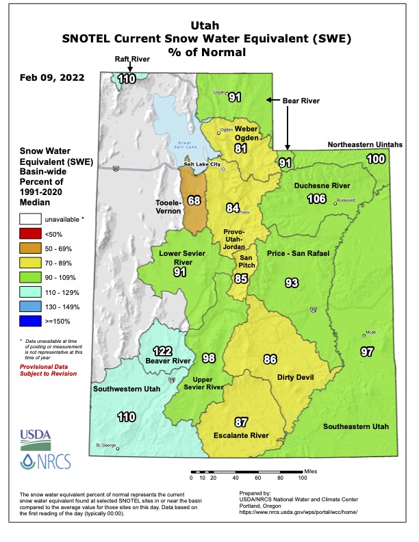
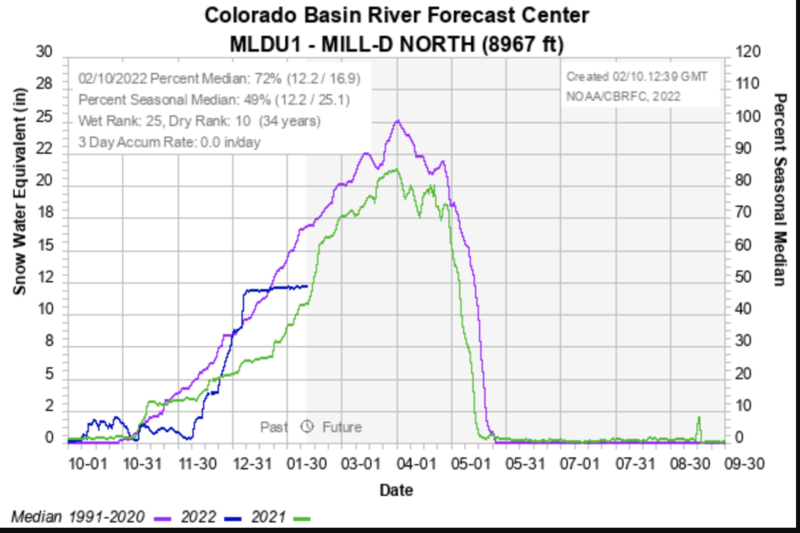
You'll see below our percent of normal as of yesterday and where our winter has, essentially since the New Year, flat-lined.
(pink is "average", green is last winter, blue is the where we've essentially flat-lined)
Recent Avalanches
No new avalanche activity was reported. You can find all the backcountry observations HERE.
Ad
Avalanche Problem #1
Normal Caution
Type
Location
Likelihood
Size
Description
The snowpack is generally stable and natural and human-triggered avalanches are unlikely. In isolated areas, you may encounter
  • Pockets of fresh wind drifted snow along exposed ridges and in open terrain at the upper elevations. Although any drifts will be shallow and not very wide, wind drifts will be sensitive if they have formed on top of weaker snow underneath.
  • Fast and long-running sluffs in the weak, cohesion-less surface snow on steep slopes on shady aspects. In confined and sustained terrain features, sluffs can pile up deeply, especially in terrain traps. On slopes where the weak snow at the surface rests on top of hard crusts, getting caught and carried in a loose sluff could have serious consequences in steep, rocky terrain as you may be unable to self-arrest on any slick surfaces underneath.
On a field day in the Uintas on Tuesday, Mark was able to find a large variety of different snow surfaces that had been impacted by the wind. The huge swings in temperature between day and night have faceted and weakened much of the surface snow. It’s not a problem until we get snow, but will become a problem when we do. Similar conditions currently exist throughout most mountain ranges in Utah.
Evaluate each slope and look for any signs of instability such as cracking in fresh wind drifts or long-running sluffs in steep terrain.
General Announcements
Who's up for some free avalanche training? Get a refresher, become better prepared for an upcoming avalanche class, or just boost your skills. Go to https://learn.kbyg.org/ and scroll down to Step 2 for a series of interactive online avalanche courses produced by the UAC.
This information does not apply to developed ski areas or highways where avalanche control is normally done. This forecast is from the U.S.D.A. Forest Service, which is solely responsible for its content. This forecast describes general avalanche conditions and local variations always occur.