Check out our Holiday Auction - Sign Up for the Utah Snow and Avalanche Workshop (USAW)

Forecast for the Salt Lake Area Mountains

Trent Meisenheimer
Issued by Trent Meisenheimer on
Thursday morning, February 1, 2024
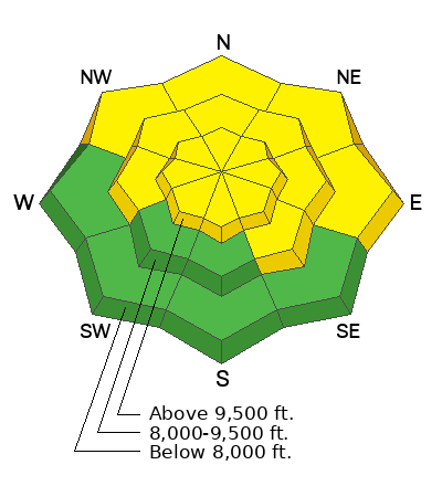
Today, there is a MODERATE avalanche danger that exists on steep west to north to southeast facing slopes for triggering a 2-5' thick hard slab avalanche that fails on a buried persistent weak layer of faceted snow. We also have a MODERATE avalanche danger for triggering a shallow soft or hard slab of Wind-Drifted Snow.
As the storm moves in, be willing to change and adjust your travel plans based on changing avalanche conditions. The avalanche danger will be on the rise through the weekend.
Low
Moderate
Considerable
High
Extreme
Learn how to read the forecast here
Avalanche Watch
What: The danger of avalanches is expected to increase Friday and Saturday as a winter snow storm adds snow to an existing weak snowpack.
When: In effect from 6 AM MST this morning to 6 AM MST Friday
Where: For the mountains of Southwestern Utah, including terrain around Brian Head ski resort and surrounding areas.
Impacts: Expected heavy snowfall coupled with very weak existing snow could produce dangerous avalanche conditions. Friday and Saturday are the most likely days for avalanches. An avalanche Warning will be issued Friday if expected snow accumulates tonight.
Warning Times: Thursday, February 1, 2024 - 6:45 AM to Friday, February 2, 2024 - 6:00 AM
Region: Southwest Utah
Weather and Snow
"The Times They Are a-Changin." Current mountain temperatures range from 22-30 °F and will be on a general cooling trend over the next 24 hrs. Winds are from the south and southeast, blowing 15-25 mph and gusting into the 30s across most upper-elevation terrain. The most exposed peaks blow 30-40 mph, gusting into the 40s.
Today, we will see increasing clouds on a southerly flow. Temperatures will climb into the low to mid-30s °F. Winds will remain from the south and southeast for the day and continue to blow in the 20-30 mph range with gusts into the 40s. Winds are forecast to have a period of powerful gusts to 75 mph later this afternoon. Precipitation will begin sometime between 2:00-8:00 PM today depending on which model you look at. In either case, we are only expecting a couple of inches by sundown.
As the snow starts to fall, it will have a convective component, meaning it might snow really hard in certain areas as the strong southerly winds swirl and mix the warm and cold air and force it to rise up and over the mountains. Initially, snow densities will be on the higher side. All said and done we could stack up 10-20 inches of new snow (1.0-2.0 inches water) by the weekend.
Buckle up; another wet and windy storm begins on Monday.
Recent Avalanches
No new avalanches were reported yesterday. However, we have seen two close calls and one natural avalanche in the past few days. List below:
Ad
Avalanche Problem #1
Persistent Weak Layer
Type
Location
Likelihood
Size
Description
On January 4, a widespread persistent weak layer of faceted snow was buried and preserved. Since then, we've had several storms, which have built a strong, hard slab of snow over this weak layer. This weak layer is now buried roughly 2-5 feet deep and is widespread throughout Utah. At first, this layer was very sensitive, and the avalanche danger was in your face. You could sneeze and trigger an avalanche.
So what's changed? Well, "The Likelihood" meaning the possibility of triggering an avalanche, has gone down. BUT, the consequence of the avalanche has remained the same. Today and into the weekend, as we stack up the snow (add weight) the likelihood will again be on the rise.
Trend: Increasing danger
Avalanche Problem #2
Wind Drifted Snow
Type
Location
Likelihood
Size
Description
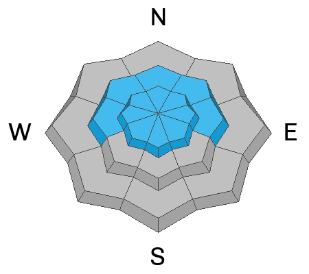
Strong south and southeast winds will try to grab or erode whatever snow they can find. While there is not a lot of snow available for transport, I've always been amazed at what the wind can find and where it can deposit fresh drifts. Therefore, be on the lookout for shallow soft and hard slabs of wind-drifted snow.
Trend: Increasing danger
General Announcements
This information does not apply to developed ski areas or highways where avalanche control is normally done. This forecast is from the U.S.D.A. Forest Service, which is solely responsible for its content. This forecast describes general avalanche conditions and local variations always occur.