Forecast for the Salt Lake Area Mountains

Nikki Champion
Issued by Nikki Champion for
Monday, February 1, 2021
The avalanche danger is CONSIDERABLE on upper elevation aspects and mid-elevation aspects facing northwest, through north, through southeast. This weekend's new snow and recent strong southerly winds have overloaded the snowpack on many slopes at the mid and upper elevations. Dangerous avalanche conditions exist. Any natural or human-triggered avalanche can be 2-4' deep, over a few hundred feet wide, and likely unsurvivable.

The remaining mid-elevation aspects and low-elevation aspects facing northwest, through north, through southeast have a MODERATE avalanche danger.

If you're leaving a resort boundary through an exit point, you are stepping into CONSIDERABLE avalanche danger.
Low
Moderate
Considerable
High
Extreme
Learn how to read the forecast here
Special Announcements
With great sadness, the Utah Avalanche Center reports that a 57-year old skier, Kurt Damschroder of Park City, was killed in a backcountry avalanche off of Squaretop Peak, located on the Park City Ridgeline. The preliminary information can be found HERE. Our thoughts go out to those affected by this tragic accident, especially the family and friends of the victim.
UAC Staff, along with PCMR Ski Patrol, investigated the accident yesterday and will have the full report available in a couple of days.
Weather and Snow
This morning, under cloudy skies we have an inversion in the mountains with temperatures ranging from the mid-teens to mid-20s F. Winds, are southwesterly, and light, averaging 10-15 mph with gusts between 20-30mph at ridgelines.
Today, high pressure will continue to build bringing mostly cloudy skies in the morning and becoming partly cloudy in the afternoon. Temperatures will be in the mid-30s F, and southerly winds will remain calm with gusts below 35 mph at the upper ridgelines.

The final rough snow totals from this past storm below:
Upper LCC: 15.5"-21" new snow (1.16 "-1.15" water)
Upper BCC: 12"-20" new snow (0.88"-1.20" water)
Park City Ridge: 10"-14" new snow (0.80"-1.1" water)
Looking ahead: The next storm system is expected to cross the area Wednesday. Some uncertainty remains concerning the timing and how the pieces will come together, but Wednesday afternoon or evening look like the window for the heaviest snowfall.
Recent Avalanches
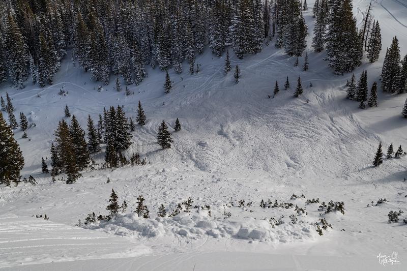
Yesterday was another active day in the backcountry, reports of avalanches continued to roll in. Between January 30th-31st, we have had 25 avalanches have been reported in the Central Wasatch backcountry. While most of these avalanches occurred on the 30th, we had two new avalanches reported in the backcountry yesterday. A few avalanches of note:
  • Claytons Peak/Lackawaxen - East Aspect - 10,400' - Occurred during a natural cycle 1/30 - The avalanche broke down 3-5' deep and 1000' feet across.
  • Birthday Chutes - West Aspect - 9,600' - A skier triggered an avalanche that broke 4' deep in the weak faceted snow and 50' across
Photo of the Clayton Peak avalanche (McIntyre)
The avalanche list is growing, and as always, you can find all observations and recent avalanches HERE.
Ad
Avalanche Problem #1
Persistent Weak Layer
Type
Location
Likelihood
Size
Description
All of the recent humans triggered, and natural avalanche activity over the past two days tells us that our weak and faceted snowpack has reached its breaking point.
The snowpack is starting to show its cards and is now producing deep and dangerous avalanches that are breaking 2'-4' deep and hundreds of feet wide. If the area has any signs of wind loading from late last week, we could see even deeper avalanches breaking, up to 5-10' deep, that initially fail in the wind drifted snow and step down into the weak faceted snow near the ground. Either way, these avalanches are likely to be unsurvivable.
Bottom Line: Our snowpack is a junk show and shouldn't be messed with right now. There is no outsmarting this problem - avoidance is the answer. Even as we see less frequent avalanche activity, the current snowpack conditions we have are perfect for an avalanche accident. If you're heading out into the backcountry today, be sure to stick to terrain that's under 30° degrees in slope steepness with nothing steep above or adjacent to you. Avalanches can be triggered from a distance, and from below. Dangerous avalanche conditions exist, and human triggered avalanches are likely.
General Announcements
Please visit this website with information about Responsible Winter Recreation by the Utah Office of Outdoor Recreation.

This information does not apply to developed ski areas or highways where avalanche control is normally done. This forecast is from the U.S.D.A. Forest Service, which is solely responsible for its content. This forecast describes general avalanche conditions and local variations always occur.