Check out our Holiday Auction - Sign Up for the Utah Snow and Avalanche Workshop (USAW)

Forecast for the Salt Lake Area Mountains

Trent Meisenheimer
Issued by Trent Meisenheimer on
Saturday morning, December 30, 2023
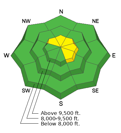
The avalanche danger is MODERATE on steep slopes that face northwest, north, northeast, east, and southeast for shallow soft or hard slabs of wind-drifted snow. Human-triggered avalanches are possible.
You will find a LOW avalanche danger out of the wind-effected snow where human-triggered avalanches are unlikely.
Low
Moderate
Considerable
High
Extreme
Learn how to read the forecast here
Special Announcements
To fulfill our mission, the UAC relies on our amazing backcountry community. Your support helps pay for the daily avalanche forecast, free awareness presentations across the state, and new tools like the new Avalanche and Observation Explorer. As the end of the year approaches, please consider donating to the UAC.
Weather and Snow
As a closed low spins counterclockwise (cyclonic) over Las Vegas, we will see a slight increase in southerly winds, temperatures, and clouds. Unfortunately, this storm will likely bring little to no precipitation as it tracks too far south before it fizzles out over New Mexico.
This morning, under mostly cloudy skies, the current mountain temperatures range from 20-30 °F. Winds blow from the southwest at speeds of 10-15 mph, gusting into the 20s. Some wind sites are blowing stronger than others. At 11,000', the winds blow from the southwest at 20-30 mph gusting into the 40s.
The riding and turning conditions remain excellent in the wind and sun-sheltered slopes. On sunny aspects there will be a crust from the past few days of strong sunshine. Our snowpack is supportable, and the travel is easy.
Recent Avalanches
None.
Ad
Avalanche Problem #1
Wind Drifted Snow
Type
Location
Likelihood
Size
Description
It's hard to ignore the bump in southerly wind speeds. Yesterday, around 5:00 PM, winds picked up out of the south and have continued to blow 10-15 mph, gusting into the 20s across most of the upper elevation ridgelines.
Today, be on the lookout for fresh, soft, or hard slabs of wind-drifted snow. These slabs will likely be less than a foot deep, but they could be sensitive to the weight of humans because our surface snow is very weak and faceted.
If you find yourself on firm hard snow, or snow that is stiff, punchy, or upside down, you've likely found a wind slab, and it's possible it could avalanche. Remember, shooting cracks or whumpfs (collapsing) are signs of unstable snow. The easiest and safest thing to do is to stay in the soft, re-crystalized snow with no wind effect and therefore, no avalanche issues. This will also be where the best riding and turning will be.
General Announcements
This information does not apply to developed ski areas or highways where avalanche control is normally done. This forecast is from the U.S.D.A. Forest Service, which is solely responsible for its content. This forecast describes general avalanche conditions and local variations always occur.