Join us for the 17th Annual Professional Snow and Avalanche Workshop (PROSAW) on November 4 - Purchase tickets here!

Forecast for the Salt Lake Area Mountains

Dave Kelly
Issued by Dave Kelly on
Monday morning, December 26, 2022
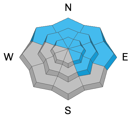
The avalanche danger is MODERATE on all slopes facing northwest through north and east and mid and upper elevation slopes facing southeast. Human-triggered avalanches are possible and avalanches may break 1-4' deep.
The avalanche danger is LOW on all other slopes.
Low
Moderate
Considerable
High
Extreme
Learn how to read the forecast here
Weather and Snow
It is currently snowing at the top of the Cottonwood Canyons. This low density snow should clear out with sunrise. Temperatures are in the low 30's F at the trailheads and in the mid 20's F at the higher elevations. Winds are westerly in the mid teens MPH gusting to the low 20's MPH.

Today, mostly cloudy. Temperatures will be 36-40 F. Winds at the 9000' ridgelines will blow from the southwest 15 gusting to 25 MPH and at the 11,000' ridgelines 20 gusting to 35 MPH.

The National Weather Service is forecasting an atmospheric river event to hit the Wasatch Range mid-day Tuesday through Thursday with 2.25"-3.25" of water and up to 36" of snow.
Recent Avalanches
There were reports of roof slides in Big Cottonwood Canyon neighborhoods yesterday.
Ad
Avalanche Problem #1
Persistent Weak Layer
Type
Location
Likelihood
Size
Description
The persistent weak layer (PWL) that formed in mid-November and was subsequently buried is still distinguishable in snowpits at all aspects and elevations. Yesterday at the top of Little Cottonwood Canyon, my partner and I were still seeing propagation with extended column tests. This buried weak layer of facets is suspect and I would not travel into steep terrain without conducting a series of snowpack tests and only exposing one person to a slope at a time.

Most avalanche activity on this layer has been on northerly facing terrain. This layer DOES exist in other places as I found yesterday, and it could begin producing avalanches when it gets loaded by a series of storms this week.
Avalanche Problem #2
Wet Snow
Type
Location
Likelihood
Size
Description
With warm temperatures forecasted today and some lower elevation areas remaining above freezing for the last twelve hours I would not be surprised to see some wet loose activity with any hint of sun.

Stay away from any roof that is still holding snow as it may release and cause injury to adults. Be especially watchful of children playing near buildings.
General Announcements
Help support the UAC while doing your Holiday Shopping. The UAC's Holiday Silent Auction opens at 8:00 AM MT on December 26 and will close at 8:00 PM MT on January 2. Take a look at items and bid HERE.

This information does not apply to developed ski areas or highways where avalanche control is normally done. This forecast is from the U.S.D.A. Forest Service, which is solely responsible for its content. This forecast describes general avalanche conditions and local variations always occur.