Join us at our 2nd Annual Blizzard Ball

Forecast for the Salt Lake Area Mountains

Trent Meisenheimer
Issued by Trent Meisenheimer on
Sunday morning, December 24, 2023
Today, the avalanche danger is MODERATE across all upper elevations for Wind-Drifted Snow. Here, you can find soft slabs of wind-blown snow that could be sensitive to the weight of riders.
Out of the wind zone, our biggest concern will be dry-loose avalanches (sluffing) within the 3-6 inches of new snow.
Low
Moderate
Considerable
High
Extreme
Learn how to read the forecast here
Special Announcements
To fulfill our mission, the UAC relies on our amazing backcountry community. Your support helps pay for the daily avalanche forecast, free awareness presentations across the state, and new tools like the new Avalanche and Observation Explorer. As the end of the year approaches, please consider donating to the UAC.
Weather and Snow
Under mostly clear skies, the mountain temperatures are cold and range from 5-8 °F. Winds continue to blow from the northwest but have slowed dramatically, and only a few anemometers report 5-10 mph wind speeds. At 11,000', the winds are a little stronger and blow from the northwest at 15-20 mph. In the past 24 hours, we've received a relatively even coat of fresh white paint. Storm totals range from 3-6 inches of new snow (0.35-0.63 water).
Today, we will have clearing skies as the storm exits and high-pressure returns. Winds should be on their best behavior and only blow 5-15 mph from the north. It will be a cold day as temperatures will only climb into the upper teens °F by this afternoon.
The recent storm has improved the riding and turning conditions dramatically, especially on aspects that still had dry cold snow underneath. On sunny slopes, there is a hard, slick, frozen crust in many spots where backcountry riders reported needing ski crampons in steep exposed terrain.
Recent Avalanches
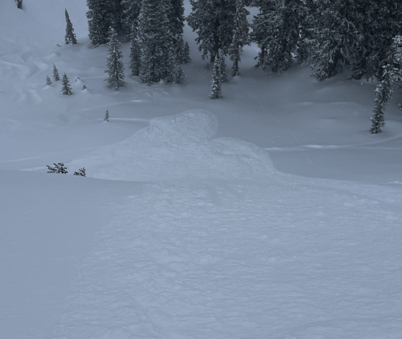
Yesterday, the avalanche activity was confined to the new snow, where backcountry observers reported dry-loose avalanches being easy to initiate in the steeper terrain. Some people reported these dry-loose avalanches entraining a fair bit of snow as they traveled downhill fast and far.
Photo: Greg Gagne showing the dry-loose avalanche problem yesterday.
Ad
Avalanche Problem #1
Wind Drifted Snow
Type
Location
Likelihood
Size
Description
As you travel across upper elevation ridgelines be on the lookout and avoid fresh drifts of wind-blown snow. These shallow, soft slabs of wind-drifted snow will likely be less than a foot deep, but they could be reactive today, especially on slopes where the old snow surface is weak and faceted (northerly-facing terrain).
Avalanche Problem #2
New Snow
Type
Location
Likelihood
Size
Description
Out of the wind, you will want to watch for dry-loose avalanches within the new snow (sluffs). Yesterday, backcountry observers reported our recent 3-6 inches of snow made it easy to initiate sluffs in steep, sustained terrain. These sluffs picked up a fair bit of snow and traveled fast and far downhill.
Plan where your sluff will go today and avoid getting tangled up in it. Slope cuts are an effective tool when dealing with this type of avalanche problem.
Additional Information
What happened to the Persistent Weak Layer (PWL) problem? The PWL problem first appeared in the December 1 forecast and was removed from the forecast on Wednesday, December 20. On Thursday, December 21, forecasters Nikki Champion and Greg Gagne talked about the PWL problem over a Zoom call and their 5-minute discussion. Be sure to watch the video.
General Announcements
This information does not apply to developed ski areas or highways where avalanche control is normally done. This forecast is from the U.S.D.A. Forest Service, which is solely responsible for its content. This forecast describes general avalanche conditions and local variations always occur.