Join us at our 2nd Annual Blizzard Ball

Forecast for the Salt Lake Area Mountains

Nikki Champion
Issued by Nikki Champion on
Monday morning, December 23, 2024
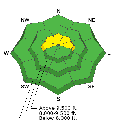
Avalanche danger is MODERATE on upper-elevation slopes facing west, north, and east. Avalanches 1-3 feet deep are possible, with hard slabs failing on a persistent weak layer of faceted snow. Recently wind-loaded slopes at upper elevations have been the most reactive. Be sure to evaluate snow and terrain carefully.
The snowpack structure remains poor and continues to weaken, setting up dangerous conditions heading into the holidays or the next significant loading event.
Low
Moderate
Considerable
High
Extreme
Learn how to read the forecast here
Special Announcements
Now is a great time to dial in your safety gear, including putting fresh new batteries in your beacons! Local shops across the state will be handing out free Batteries for Beacons from now until February 1, 2025. All you need to do is fill out a quick survey and grab the AAA or AA batteries you need to keep your beacon fresh this season. Find participating shops and more info here.
Weather and Snow
This morning, temperatures have dropped slightly under overcast skies. Trailhead temps are in the low 30s°F, and ridgetop temps are in the mid-20s°F. Snowfall totals range from a trace to 1 inch as of 5 AM. Winds at 9,000 feet are west at 20 mph, gusting to 30 mph, with northwest winds at 11,000 feet sustained at 35 mph, gusting to 55 mph.
Today, a weak system will bring light snow from late morning to afternoon, followed by a brief period of light riming this evening. A ridge of high pressure will build in late tonight through Tuesday. Temperatures will reach the mid-30s°F. Winds will be westerly at 9,000 feet, 5-15 mph, and 20-25 mph at 11,000 feet, gusting to 35 mph. Snow accumulation will be 0.5 to 2 inches.
Outlook: The Christmas storm is weakening, with the low-pressure system expected near the Utah-Arizona border. Snow will start Tuesday evening with southwest winds. A cold front will bring upslope snow Wednesday morning. Expect 3-8 inches and 0.30-0.70 inches of SWE, but some uncertainty remains. Light easterly winds are possible Wednesday if the low tracks near the border.
The active pattern continues with more snow Thursday, Friday, and possibly next weekend, though the storm track is shifting north.
Warm conditions have dampened snow, even near upper elevations. Areas that refroze overnight may have a firm crust, while zones that didn't experience a freeze could have sticky skinning. Bring skin wax today.
Recent Avalanches
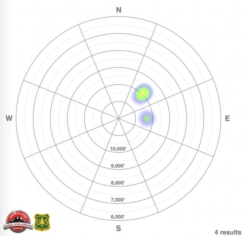
No new avalanches were reported in the backcountry yesterday. Ski resorts had little to no results from explosives but continue to report a weak snowpack. The most recent backcountry avalanche occurred Saturday in South Monitor, breaking 2 feet deep on a facet layer at 9,990 feet on a northeast aspect. In the past 8 days, 4 avalanches have been reported in the Salt Lake, Provo, and Ogden area mountains, all above 9,800' on northeast or east-facing aspects.
See the avalanche heat map.
Ad
Avalanche Problem #1
Persistent Weak Layer
Type
Location
Likelihood
Size
Description
A persistent weak layer (PWL) of faceted snow exists on northerly-facing slopes at mid and upper elevations. This layer has the potential to produce avalanches ranging from 1 to 3 feet deep and over 100 feet wide. Recent avalanche activity and field observations indicate that slopes most prone to sliding are those that have been recently wind-loaded or have a slab of stronger snow overlaying the buried PWL (see video).
Although the PWL is present at both mid and upper elevations, as we move further from the most recent notable loading event and experience additional days of warm weather, the likelihood of triggering an avalanche on this layer at mid-elevations has decreased. However, the layer still exists and will become problematic again with additional loading.
Be cautious of westerly, northerly, and southeasterly facing upper-elevation slopes, which have received the most wind and snow and where temperatures have remained cooler.
Video: Greg Gagne explaining the snowpack structure.
General Announcements
This information does not apply to developed ski areas or highways where avalanche control is normally done. This forecast is from the U.S.D.A. Forest Service, which is solely responsible for its content. This forecast describes general avalanche conditions and local variations always occur.