Join us at our 2nd Annual Blizzard Ball

Forecast for the Salt Lake Area Mountains

Trent Meisenheimer
Issued by Trent Meisenheimer on
Monday morning, December 2, 2024
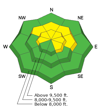
The avalanche danger is MODERATE on mid and upper-elevation slopes facing northwest through east and upper-elevation slopes facing southeast and west. In this terrain, human-triggered avalanches failing on a Persistent Weak Layer 1-2 feet deep and up to 100 feet wide are possible. The most suspect slopes will be ones loaded by the wind.

The best and safest riding conditions will be in wind and sun-sheltered terrain under 30 degrees in slope steepness. Here, you will avoid the avalanche danger by being on a slope less than 30°. And, just as important, you will find soft snow and can avoid hitting rocks while you turn.
Low
Moderate
Considerable
High
Extreme
Learn how to read the forecast here
Special Announcements
The 17th Annual Utah Snow and Avalanche Workshop (USAW) is scheduled for Saturday, December 7th. Information and tickets are available here.
Park City Mountain Resort (PCMR) will be conducting explosive work and has closed its boundaries. Please respect these closures if you're along the PC ridgeline or adjacent to PCMR.
Weather and Snow
Under clear skies, the mountain temperatures range from 20-32 °F. The wind has veered from the northwest to the northeast and now blows 5-15 mph across most upper-elevation terrain.
Today, we expect clear and sunny weather, with temperatures rising into the upper 30s and low 40s at about 8,500'. The wind will continue to blow from the northeast at speeds of 5-15 mph.
It's been five nights of clear skies and cold temperatures. The Diurnal cycle (day to night) is taking its toll on our snow surface. Temperature changes and the energy balance of incoming shortwave radiation and longwave outward radiation are causing our adolescent snowpack to deteriorate, becoming weaker and weaker and more faceted every day. The good news is that the riding and turning conditions are pretty good. The bad news is that we are developing a nasty weak layer that will haunt us in the future.
I looked for a storm in fairy tale land (six days out on the GFS) and saw one around Sunday, December 8th. Until then, like a ship stuck at sea with no wind, we are in the doldrums of high pressure.
Recent Avalanches
Many slab avalanches were triggered last week (26th, 27th, and 28th) on our Persistent Weak Layer. Be sure to check out the avalanche list, which can be found HERE. The last reported avalanche was on Saturday November 30th along the Park City Ridgline in South Monitor.
Ad
Avalanche Problem #1
Persistent Weak Layer
Type
Location
Likelihood
Size
Description
On mid and upper-elevation slopes facing northwest through east and upper-elevation southeast and west, you'll find a poor snowpack structure where stronger snow (slab) is over weaker (faceted) snow. Here, it remains possible for a human to trigger a slab avalanche that fails 1-2 feet deep and up to 100 feet wide.
As our snowpack continues to get weaker and weaker (more faceted), we will see classic signs like cracking and collapsing disappear. This problem will likely become dormant in a few days as the weak layer adjusts to the storm snow. Until then, I will continue practicing some patients, as the last avalanche was triggered just two days ago.
General Announcements
This information does not apply to developed ski areas or highways where avalanche control is normally done. This forecast is from the U.S.D.A. Forest Service, which is solely responsible for its content. This forecast describes general avalanche conditions and local variations always occur.