Join us at our 2nd Annual Blizzard Ball

Forecast for the Salt Lake Area Mountains

Greg Gagne
Issued by Greg Gagne on
Friday morning, December 2, 2022
An avalanche warning has been issued with a HIGH avalanche danger at the mid and upper elevations and CONSIDERABLE danger at low elevations. Avalanches are likely and travel in avalanche terrain is not recommended. Avoid being on or underneath slopes 30° or steeper.

Avalanche activity will involve recent and fresh slabs of fresh wind-drifted snow at the mid and upper elevations where avalanches over 3' deep may occur. The new snow may also be sensitive, especially during the morning.

Great riding conditions will be found in low-angled, wind-sheltered terrain with nothing steep above you.
Low
Moderate
Considerable
High
Extreme
Learn how to read the forecast here
Avalanche Warning
Widespread avalanche activity is expected and the avalanche danger is HIGH. The avalanche warning is in effect until 6 a.m. MST Saturday for the mountains of Northern Utah including the Wasatch Range, Bear River Range, and Western Uinta Range. A rapid load of heavy snow combined with very strong winds and preexisting weaknesses in the snowpack have created dangerous avalanche conditions. Both human triggered and natural avalanches are likely. Stay off of and out from under slopes steeper than 30 degrees.
Special Announcements
Join the Utah Avalanche Center and the Utah Division of Outdoor Recreation to celebrate the Fourth Annual Avalanche Awareness week, from December 4 - December 11. Click HERE to view the full list of events for the week.

HEADS UP - Deer Valley will be conducting avalanche control work near Empire Canyon; please avoid this terrain.
Weather and Snow
This Morning: A cold front came crashing through in the early morning hours and snowfall totals as of 6 am include 10-12" in the Cottonwoods and 8" along the Park City ridgeline. Winds have been blowing strong out of the south/southwest for the past 48+ hours and have now veered to the west/northwest. At upper elevations, winds are averaging in the 30's mph and gusting into the 60's mph. At mid elevations, winds are averaging in the teens and 20's mph with gusts in the 30's mph. Temperatures have dropped to the single digits and low teens F.
Today: Another 2-4" of snowfall is possible before the sky begins to clear out by late morning. Temperatures will be in the upper teens and low 20's F with west/northwest winds blowing in the 20's and 30's mph at 10,000' with stronger gusts into the 40's and 50's mph at the upper elevations.

Active weather continues with unsettled weather for Saturday followed by another storm on Sunday and Monday. Hello winter!
Recent Avalanches
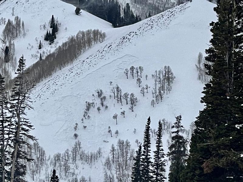
Avalanche activity on Thursday involved wind-drifted snow and included snow safety teams triggering avalanches failing in facets down at the ground and a:
natural avalanche on a northeast aspect at 9,000' in Beartrap Fork (photo below from Tim Mathews):
skier-triggered avalanche on a northwest aspect at 8,500' in Mineral Fork.
Notice the elevations occurred between 8,500 and 9,000' indicating how the strong south/southwest winds on Thursday were drifting snow at the mid elevations.
We have received many excellent observations over the last several days and it is worthwhile reading through them as a regular part of your trip planning. Please keep them coming. You can submit an observation here or via the link at the top of this page.
Ad
Avalanche Problem #1
Wind Drifted Snow
Type
Location
Likelihood
Size
Description
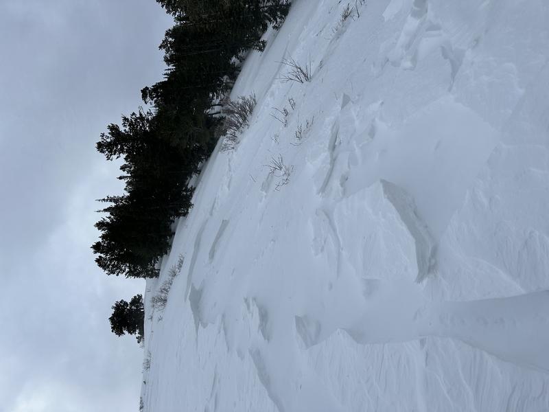
The west/northwest winds have plenty of new snow to work with and fresh slabs of wind drifted snow may be sensitive and up to 6-18" thick. You are most likely to find fresh wind-drifted snow on leeward aspects facing north through east and south, but the strong winds can work around terrain features which means wind drifts can be found on any aspect at the mid and upper elevations. Cracking in the denser, wind-drifted snow is a sign of instability. Julian Kallian's observation from Mineral Fork on Thursday (photo below) provides an excellent example of sensitive, fresh wind-drifted snow:
Trend: Steady
Avalanche Problem #2
Persistent Weak Layer
Type
Location
Likelihood
Size
Description
Cold and dry weather during the middle of November created a persistent weak layer (PWL) of faceted snow on nearly all slopes. This PWL is now covered by (1) 12-18" of storm snow earlier this week, followed by (2) over two days of intense winds that created hard slabs of wind-drifted snow at the mid and upper elevations and now (3) nearly an additional foot of new snow overnight. All of this means there are now dense slabs of new and wind-drifted snow 2-4' deep in places on top of this buried PWL. Avalanches failing on this PWL may be over 3' deep and propagate hundreds of feet wide.
The strong winds from Wednesday/Thursday and overnight into Friday morning have complicated things with no clear pattern of where the wind drifted snow has loaded the slopes. You may - or may not - get warning signs of collapsing and these dense slabs may allow you to get well onto a slope before avalanching, possibly well-above you. The only strategy is avoid all avalanche terrain as the buried PWL is widespread on almost most aspects and at all elevations.
Trend: Steady
Avalanche Problem #3
New Snow
Type
Location
Likelihood
Size
Description
I am guessing there was a natural avalanche cycle involving the new snow with the intense snowfall rates during frontal passage between 3 and 5 am this morning, and you may still find the new snow sensitive this morning, especially during any period of high snowfall rates. Watch for sluffing or sensitive soft slabs of new snow as signs of instability. The new snow should become less sensitive as the day progresses and snowfall ends.
Trend: Decreasing
General Announcements

This information does not apply to developed ski areas or highways where avalanche control is normally done. This forecast is from the U.S.D.A. Forest Service, which is solely responsible for its content. This forecast describes general avalanche conditions and local variations always occur.