Forecast for the Salt Lake Area Mountains

Greg Gagne
Issued by Greg Gagne for
Thursday, December 13, 2018
The avalanche hazard is Considerable at the upper elevations facing north through southeast. The combination of storm snow and wind drifts may be enough to overload buried, persistent weak layers on these aspects, with avalanches breaking down 3' or more. Also watch for fresh wind drifts and lingering sensitive storm snow on all upper elevation aspects.
The avalanche hazard is Moderate at the mid elevations, as well as upper elevations facing northwest through south. On mid elevations facing west and southwest, as well as all low elevations, the hazard is Low.
Low
Moderate
Considerable
High
Extreme
Learn how to read the forecast here
Special Announcements
UDOT will be performing control work above the Alta bypass road around 7 am with a brief closure expected at that time.
The new UAC IOS mobile app is now available on the app store. Check out the new "My Weather" feature.

Check out the new free online avalanche course series developed by the Utah Avalanche Center. This is a great way to refresh your skills or prepare you for a Backcountry 101 or Level 1 class.
Weather and Snow
A sharp cold front entered the Salt Lake mountains mid-morning yesterday, accompanied with strong winds and heavy precipitation throughout the afternoon, with snowfall rates of 1-2" per hour at times. Moderate to strong west/northwest winds persisted well into the evening hours, with gusts exceeding 90 mph at 11,000'. Even at the friendlier elevation band between 9000' and 10,500' winds were gusting into the 40's and 50's mph.
The all-important snowfall totals range from 6" to 13" with 0.5 - 1.0" of water, with upper Little Cottonwood coming out on the higher end.
Winds have backed off considerably since Wednesday afternoon, and are currently northwesterly and generally light, with 10,500' stations gusting in the teens. At 11,000' winds are gusting into the 30's mph. Mountain temperatures this morning are in the single digits.
Mountain temperatures will rise into the 20's at the mid elevations, and teens at upper elevations. Winds will be northwest/west and generally light, although upper-elevation ridgelines may gust into the 20's mph. Skies will be mostly sunny with a few passing clouds. Enjoy the fresh snow while it lasts as there does not appear to be any significant weather for at least the next 7 days.
Recent Avalanches
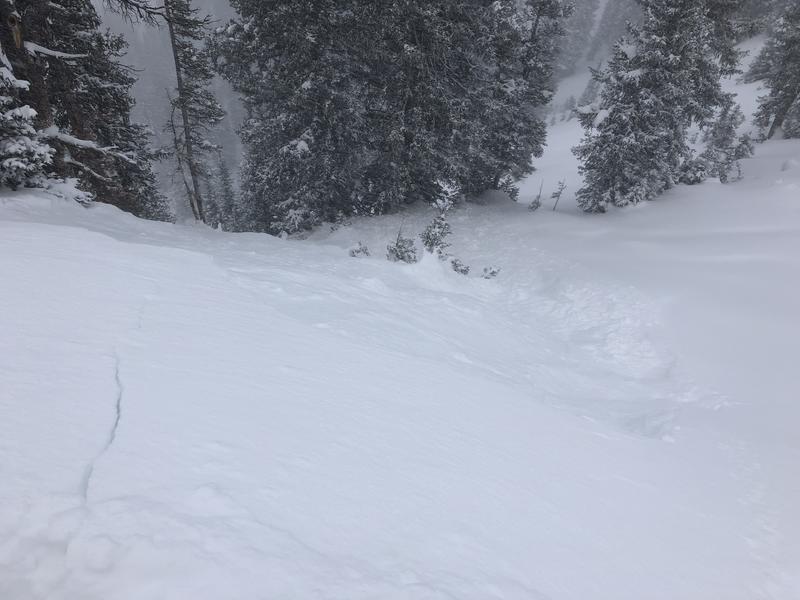
Few people getting out and very poor visibility limited field observations from Wednesday, but there were reports of cracking in the new snow during periods of heavy precipitation intensity, especially in wind-loaded areas.Yesterday I was able to easily pry out a few soft slab avalanches from safer ridgelines and test slopes (photo below), and there were also reports of a few natural avalanches on upper elevation northerly aspects later yesterday afternoon. Reported avalanche activity was running in density inversions within the storm snow, or at the interface of the old snow surface.
Ad
Avalanche Problem #1
Wind Drifted Snow
Type
Location
Likelihood
Size
Description
The strong winds on Wednesday were not only loading slopes with an easterly aspect, but also cross-loading across terrain features, creating possible drifts on all upper elevation aspects. Although I am expecting recent drifts to be less sensitive today, you may encounter drifts 6-12" thick, with pockets up to 2' in places, especially along mid and upper elevation aspects facing northeast through southeast. Watch for the obvious clues including hollow-sounding, rounded pillows of snow.
Also watch for sensitive, fresh cornices that formed along ridgelines from Wednesday's strong wind event.
Avalanche Problem #2
Persistent Weak Layer
Type
Location
Likelihood
Size
Description
Was Wednesday's 0.5" - 1" of water weight and additional wind loading enough to reactivate our mostly-dormant persistent weak layer? I don't know. But I am concerned the rapid load may have been enough to stress the weak October snow in isolated places. This includes steep, rocky terrain in areas that received the most snow and wind (such as upper Little Cottonwood) as well as repeater slopes that have already slid this season, but where weak faceted snow still remains.
I closely watch prior avalanche activity as it often is the best clue to future avalanching. One slide that I am keeping in mind was a natural avalanche that occurred on West Monitor Bowl early on the morning of Monday December 3. This was on a northerly aspect, 33 degrees in steepness, failing on October facets. (Read Mark White's usual excellent observation here.) This was a repeater avalanche where the snow/water totals from the previous day (Sunday Dec 2) was less than yesterday's load, and winds were significantly lighter than yesterday's gale force winds.
The good news is that yesterday's storm snow filled in our old, beaten-down snow surface and there is once again plenty of excellent - and safer - riding alternatives on southerly aspects as well as lower-angled slopes not connected to steeper terrain above.
Avalanche Problem #3
New Snow
Type
Location
Likelihood
Size
Description
Storm snow instabilities peak during high precipitation periods, and generally quickly diminish afterwards. For today you may still find sensitive storm snow at the upper elevations, especially in areas that received the most snow such as upper Little Cottonwood. I am expecting this hazard to diminish throughout the day. A well-placed ski cut at the top of a slope is a good way to evaluate - and mitigate - this hazard. As always, before making any ski cut, make sure you have a safe zone to move over to, and be 100% sure no one is below you.
Additional Information
Help us verify our forecasts and let us know what you see out and about in the backcountry. Trigger an avalanche? Hear a whumph? Submitting observations is easy. Click on Observations and Avalanches in the menu bar at the top or from the convenience of your smartphone. I'll run you through the smartphone observation in the video below.
General Announcements
This information does not apply to developed ski areas or highways where avalanche control is normally done. This forecast is from the U.S.D.A. Forest Service, which is solely responsible for its content. This forecast describes general avalanche conditions and local variations always occur.