Join us at our 2nd Annual Blizzard Ball

Forecast for the Salt Lake Area Mountains

Greg Gagne
Issued by Greg Gagne on
Friday morning, November 12, 2021
Although the snowpack is generally stable and avalanches are unlikely, it may be possible to find recent and fresh wind drifts along upper elevation ridgelines that are reactive.
A few things to remember:
  • Triggering any avalanche regardless of its size can produce serious trauma even if it doesn't bury you because the snowpack is so thin.
  • Hitting rocks and stumps is a real danger. Don't end your season before it starts with an injury from hitting one of these obstacles.
  • Early season avalanches are a real possibility. It doesn't matter if you are hiking, hunting, skiing, etc., be prepared with the correct rescue gear and a partner. Many people have died during early season snowstorms.
  • Ski resorts all have different uphill travel policies. These closed resorts that allow uphill travel can be great places to get in a little skiing especially in you know of a rock-free slope, but it should be treated as backcountry terrain.

We will be issuing intermittent updates and publishing backcountry observations as they arrive. When we begin regular forecasts, we will begin issuing avalanche danger ratings.
Low
Moderate
Considerable
High
Extreme
Learn how to read the forecast here
Special Announcements
Early season is a great time to be thinking about increasing your avalanche education - Check all the upcoming education HERE.
Weather and Snow
A storm this past week delivered 8-12" of dense snow with some graupel, with the highest amounts in upper Little Cottonwood Canyon. Winds have been from the west/northwest this week and have remained elevated, especially at the upper elevations, with averages in the 40's and gusts in the 60's mph. Wind speeds have diminished throughout the day on Friday.
Snow depths are roughly 1.5 - 3' deep above on north-facing slopes above about 9000', and the dense snow from this past week is supportable, creating decent travel conditions for an early season snowpack.
For this weekend, mostly sunny skies with mild temperatures are forecasted with overnight lows right around freezing and temperatures rising into the upper 30's and low 40's F. Winds will be from the west/northwest with gusts near 30 mph.
Looking ahead, winds will increase early this coming week, ahead of a cold front that should arrive around Tuesday. Although temperatures will drop noticeably behind the front, snowfall amounts are likely to be limited to a few inches at best.
Recent Avalanches
No avalanche activity has been reported. We have received several observations from the backcountry and this is a great way to stay informed on any recent avalanche activity and current snowpack conditions.
Ad
Avalanche Problem #1
Normal Caution
Type
Location
Likelihood
Size
Description
The current snowpack is generally stable and triggering an avalanche is unlikely. However (I know, there always is a "however") winds have been elevated throughout this past week and may remain gusty this coming weekend. This means small pockets of recent and fresh wind drifts are possible along upper elevation ridgelines. Although I expect any avalanches to remain small, obstacles such as rocks, stumps, and downed timber that can turn even a minor avalanche involvement into a consequential accident.
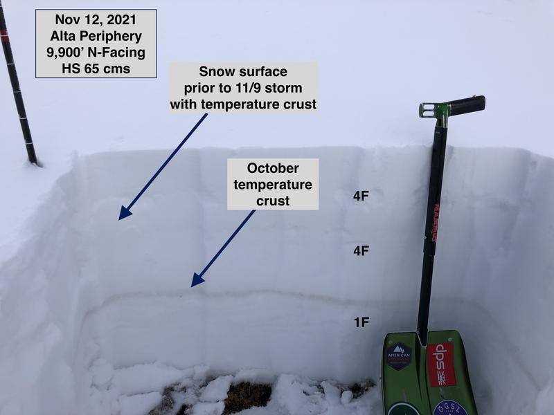
Our early-season snowpack is generally stable although there are some isolated areas with weaker snow, such as some graupel that fell during the day on Tuesday as well as some faceted snow around crusts that were near the old snow surface prior to the Tuesday storm. But overall the snowpack is right-side-up, meaning the snowpack gains strength as you work from the surface of the snow down to the ground. (Photo from Friday field work in upper Little Cottonwood Canyon.)
General Announcements

This information does not apply to developed ski areas or highways where avalanche control is normally done. This forecast is from the U.S.D.A. Forest Service, which is solely responsible for its content. This forecast describes general avalanche conditions and local variations always occur.