Forecast for the Salt Lake Area Mountains

Dave Kelly
Issued by Dave Kelly for
Friday, October 28, 2022
What a great mid-week storm! The Central Wasatch mountains reported another 7-11" of new snow while the Ogden and Provo area mountains reported a few additional inches. Snow depths throughout the range vary from a few inches to a couple of feet.
Early season conditions exist. Watch for unstable snow on isolated terrain features and remember anywhere that has snow, slope, and a trigger has the potential to avalanche.
We will update the forecast as conditions warrant.
Low
Moderate
Considerable
High
Extreme
Learn how to read the forecast here
Special Announcements
Remember to treat ski areas as backcountry terrain and check each resort's travel restrictions on the Resort Uphill Policy page before accessing their terrain.
The ski areas are getting ready for their operating seasons to start so please be respectful of equipment and employees both on and off the slopes.
Give snowcats and snowmobiles a wide berth as they move around their terrain.
Weather and Snow
The snow came in right side up and added to an already stellar base with select areas having received over 3 feet of snow since the season started.
The weekend looks to bring warmer mountain temperatures with light to moderate winds. Clear skies and seasonal temperatures may start to melt some of the snow on solar aspects and begin the faceting process on the shady high elevation aspects. Some solar warming was noted yesterday with the possibility of crusty solar surfaces and wet loose sluffs during the warmest hours of the day.
Watch for wind loading on all aspects with forecasted winds coming from all directions over the next few days. Keep an eye out for rounded pillowy pockets of snow on the leeward side of terrain features.
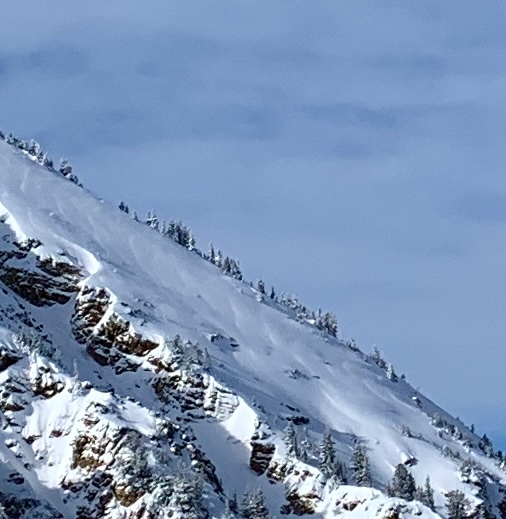
Wind scalloping noted on Baldy Shoulder (Hardesty)

Clearing weather through the weekend with the next disturbance and another storm after Halloween.
Recent Avalanches
Some small storm related avalanches were observed, probably releasing during high winds as the frontal passage moved through. Not very many reports of avalanche activity over the last few days.
Check out our observations page for the latest updates from around Utah. Please keep these observations coming.
Ad
Additional Information
A Few Things to Remember:
  • It doesn't matter what you're doing in the mountains-going for a hike, hunting, trying to ski, board, snowshoe or firing up the snowmachine: be prepared for avalanches
  • Triggering any avalanche regardless of its size can produce serious trauma because of a thin snowpack
  • Hitting rocks and stumps is a real danger. Don't end your season early from hitting one of these obstacles
  • Treat ski resorts as backcountry terrain and check out the UAC site for resort uphill travel policies

Even if you're not planning to get onto the snow, it's never too early to start thinking about avalanches. A few things to consider doing:
1. Attend USAW and learn more about avalanches and decision making. (scroll down to the bottom of this page for more info and links)
2. Sign up for an avalanche class.
4. Take the all-new online avalanche courses the UAC built for Know Before You Go or take other online courses listed on the KBYG website (Develop skills -> Online Learning).
5. Get your avalanche rescue gear ready for winter. Put fresh batteries in your transceiver and update the firmware. Inspect your shovel and probe. Get your airbag backpack ready by possibly doing a test deployment and update the firmware if it is an electric version.
Sign up for the 15th Annual Utah Snow and Avalanche Workshop (USAW) on two nights, November 2nd and 9th. Sign up and get more info for the first session HERE and the second session HERE.
The Avalanche Professional and Ski Patrol Snow and Avalanche Workshop (PROSAW) will be during the day of November 7th. Sign up and get more info HERE. (note - PROSAW will be offered both in-person and virtual).
General Announcements
Check out this great Winter Outlook 2022-2023 video put out by our partners at the National Weather Service.

This information does not apply to developed ski areas or highways where avalanche control is normally done. This forecast is from the U.S.D.A. Forest Service, which is solely responsible for its content. This forecast describes general avalanche conditions and local variations always occur.