Forecast for the Salt Lake Area Mountains

Trent Meisenheimer
Issued by Trent Meisenheimer for
Thursday, January 3, 2019
Today the avalanche danger is MODERATE on steep upper elevation slopes where slabs of wind-drifted snow can be found. Be on the lookout and avoid, rounded, pillowy, wind drifted snow. Out of the wind effected snow the avalanche danger is LOW. As the day heats up the southerly facing terrain might become loose enough to produce a few small avalanches from the direct sun.
  • More info on wind drifted snow HERE.
Low
Moderate
Considerable
High
Extreme
Learn how to read the forecast here
Weather and Snow
It will be another glorious day in the mountains today with plenty of sunshine and warming temperatures. It's easy to see the temperature inversion as many upper elevation (10,000') stations are reporting temperatures in the mid 20's °F. While the mid elevation trailheads are sitting in the single digits. The brutal northeast winds finally gave up yesterday afternoon and have now shifted to the northwest with speeds of 10-15 mph gusting into the 20's at upper elevation ridge lines.
The snow surface is a mixed bag - in places the wind crusts will make it feel like you're on the moon, while other shady, sheltered slopes will have soft settled powder that was spared from the NE winds. Southerly facing slopes will be crusted this morning and should soften with day time heating. Regardless of the snow surface, it will be a very nice day to be in the mountains.
Recent Avalanches
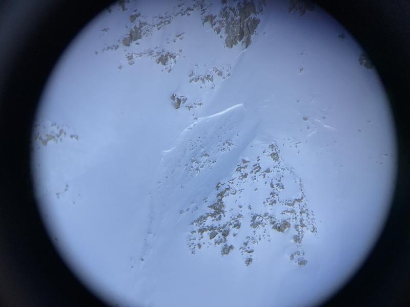
Yesterday, the sun was stronger than expected and led to a natural wet loose avalanche cycle in the afternoon. Many southerly facing slopes shed their recent coat of white paint from this past week. This creating a few debris piles that were large enough to bury or kill a person. One interested avalanche was in upper LCC under the Hellgate cliffs where a wet loose slide cascaded off the cliff above and triggered a slab that likely failed on graupel snow (see pic below).
Photo: Mark Staples, showing a slab that likely failed on graupel snow after a wet loose slide came cascading off the cliffs above.
Ad
Avalanche Problem #1
Wind Drifted Snow
Type
Location
Likelihood
Size
Description
The unusual northeast winds have been headline news for the past few days. These winds were able to grab Sunday's low density snow and drift it to a wide variety of aspects and elevations. Most of these slabs seem to be welded in place. However, it's only been 48 hrs since the NE wind event. I would expect that some slabs might be sensitive to the weight of a rider, especially, in steep, rocky, unsupported terrain. Look for and avoid rounded pillows of wind blown snow. Approach the steep slopes with caution - these hard wind drifts will likely break above you.
If you're planning on getting after it today, keep a few things in mind:
  • If you do trigger a wind slab where will it take you? cliff, trees, gulley?
  • Set yourself up for success and choose terrain with clean runouts.
  • Travel one at a time and keep an eye on your partner and be ready to help in case anything happens.
  • Be able to identify and avoid, pillowy, rounded and hollow sounding snow.
  • Avoid steep, wind loaded, rocky, terrain where your most likely to trigger a wind slab.
Photo: Bo Torrey and crew showing a wind slab avalanche that failed sometime during the wind event on Airplane Peak in LCC. This is the exact type of terrain you could expect to trigger a wind slab in.
Additional Information
As the avalanche danger decreases our terrain selection usually increases. Meaning we start venturing into bigger and steeper terrain with more consequences. One accident that really gave me a good perspective on wind slabs and terrain management happened in Montana on April 11th, 2015. Where a rider triggered a very small avalanche (10-20 feet wide and about a foot deep) and was swept off a 300' cliff.
Mark Staples gives us a good review of how even if you do everything right it can still go wrong. Give the wind slabs another day or two to bond and strengthen before committing to large terrain with bad consequences.
General Announcements
This information does not apply to developed ski areas or highways where avalanche control is normally done. This forecast is from the U.S.D.A. Forest Service, which is solely responsible for its content. This forecast describes general avalanche conditions and local variations always occur.