Join us at our 2nd Annual Blizzard Ball

Forecast for the Salt Lake Area Mountains

Nikki Champion
Issued by Nikki Champion on
Thursday morning, January 18, 2024
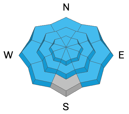
The avalanche danger is HIGH on all upper elevation aspects and mid-elevation aspects facing northwest through north and southeast aspects where new snowfall and elevated winds have created very dangerous avalanche conditions. Any avalanche triggered within the wind-drifted or new snow has the potential to step down 4-6 feet deep into the weak faceted snow within the snowpack, creating a very large and dangerous avalanche.
What to do? Stick to slopes less than a 30-degree today. Stay away from, and avoid slopes connected to, anything steeper than about 30 degrees.
Low
Moderate
Considerable
High
Extreme
Learn how to read the forecast here
Special Announcements
Weather and Snow
This morning, the skies are overcast and it is snowing lightly in some parts of the range. Temperatures range from the upper teens to mid 20s F. Winds are coming from the west at 20-30 mph, with gusts up to 40 mph. Along the highest elevations gusts are reaching near 75 mph. Storm totals so far are between 8-15" of snow, favoring the Upper Cottonwoods.
Today, a wave is moving through the Northern Rockies and affecting northern Utah in the morning. Most of the moisture is moving eastward, so any remaining snow will be mainly influenced by moist orographics. This snowy activity is expected to continue in the morning and decrease in the afternoon. The mountains could pick up an additional 1.5-3.0" of snow. Westerly winds will remain elevated before decreasing this evening, averaging 10-15 mph at mid-elevations and 30-35 mph at the uppermost elevation, with gusts up to 65 mph. Temperatures will climb into the upper 20s and low 30s F.
More rounds of snowfall are expected from late in the weekend to the middle of next week. These systems will bring mild conditions and high-density snow. Precipitation amounts vary, but it looks like there could be close to an inch of water during these days.

With this last storm, we are back on track - most areas are at or above "median" snow-water for the year.
Recent Avalanches
Yesterday, widespread sensitive soft slab activity was reported in the backcountry, ski resorts, and even on highways. Most of these avalanches were small (D1-D2) and occurred within the new snow during periods of high precipitation intensity. None of the reported avalanches seemed to fail deeper into weak faceted layers within the snowpack.
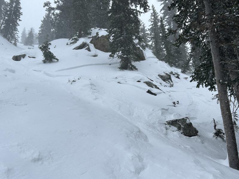
Example of a skier triggered soft slab that failed 7" deep within the new snow, in Hidden Canyon. Find the full Observation HERE.
(Photo: Aidan)
Since Friday, we've received information about two complete avalanche burials (Main Porter, American Fork) and indications of a third, all successfully rescued by partners or bystanders. Additionally, there have been reports of several skiers and riders being caught and carried, with positive outcomes. Tuesday, there was a rider triggered avalanche at an elevation of 11,000 feet in Monte Cristo Gully. A hard slab avalanche was unintentionally triggered by a snowboarder on a west-facing aspect. The avalanche, caused by the persistent weak layer and wind-drifted snow, had an average depth of 3-4 feet, a width of 600 feet, and a vertical drop of 2,750 feet. Find the full observation HERE. See video below. Unfortunately, a skier lost their life in a Wyoming avalanche on Sunday (Details).
(Video: W. Ambler)
Be sure to check all the avalanche activity HERE.
Ad
Avalanche Problem #1
Persistent Weak Layer
Type
Location
Likelihood
Size
Description
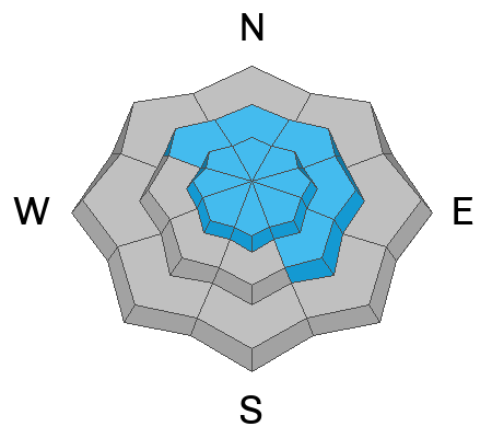
These avalanche conditions remain highly dangerous, while avalanches may not be as hair-trigger as they were over the weekend, cracking and collapsing is still present. The additional load from the last two days, in the form of new snow and wind could cause the sensitivity of this weak layer to increase yet again.

Despite the good skiing conditions, it's crucial to recognize that all aspects are suspect, and large, destructive avalanches have occurred even at lower elevations. Soft and hard slab avalanches may be more stubborn, but they can still be triggered at a distance, making survival unlikely if caught in one of these monsters.
We must allow more time for this layer. Avoid traveling in any avalanche terrain, as these avalanches could be triggered remotely, from a distance, or, worse, from below!
Avalanche Problem #2
Wind Drifted Snow
Type
Location
Likelihood
Size
Description
The westerly winds remain elevated, with overnight gusts near 75 mph. With high winds and so much soft snow available for transport, you are likely to find both soft and hard slabs of wind-drifted snow on all upper-elevation slopes, and mid-elevation terrain features that allow for drifting snow to accumulate. These slabs will be most pronounced on lee-ward facing slopes, but high winds can load any aspect because winds swirl and change direction as they pass through the mountains, this is known as cross-loading.

Though alluring, these smooth-looking, rounded pillows of snow are sitting on top of very weak, pre-existing surface snow. The best riding conditions will be in sheltered, lower-angle terrain out of the wind.
Out of the wind-zone, you will still be able to find some sensitive new snow today. Anticipate shallow new snow avalanches in the backcountry, especially in the upper elevations, with both fast-running sluffs and shallow soft slabs likely. Watch for signs of instability like cracking and sluffing, as even a small slide can pose serious risks in steep terrain or near cliffs.
General Announcements
This information does not apply to developed ski areas or highways where avalanche control is normally done. This forecast is from the U.S.D.A. Forest Service, which is solely responsible for its content. This forecast describes general avalanche conditions and local variations always occur.