Join us at our 2nd Annual Blizzard Ball

Forecast for the Salt Lake Area Mountains

Trent Meisenheimer
Issued by Trent Meisenheimer on
Sunday morning, January 17, 2021
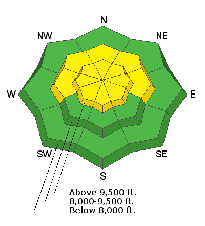
The avalanche danger is MODERATE on all steep upper-elevation aspects. On steep mid-elevation slopes facing west, through north, through east, there is also a MODERATE avalanche danger.
Any avalanche triggered could be 1-3' deep and over 100' wide. You may also find reactive soft and hard slabs of wind-drifted snow at the upper elevations as well as some mid-elevation slopes. Human-triggered avalanches are possible.
Low
Moderate
Considerable
High
Extreme
Learn how to read the forecast here
Special Announcements
Thanks to the generous support of our local resorts, Ski Utah, and Backcountry, discount lift tickets are now available. Support the UAC while you ski at the resorts this season. Tickets are available here.
Weather and Snow
This morning we are under a northwest flow as a weak ridge of high pressure builds into the area. This will lead to mostly sunny skies and elevated ridgetop winds. Temperatures will climb into the low to mid 30's °F at 9,000' this afternoon. High clouds will begin to build in by late afternoon ahead of another weak trough that will perhaps, bring another 1,000 snowflakes.
Northwest winds picked up last night around 7:00 pm and are currently blowing 40-50 mph gusting 70 mph at 11,000'. Even the 10,000' ridgetop winds have increased and are spinning anemometers 15-20 mph, gusting into the upper 20's.
Yesterday's skiff of new snow was a big improvement to the riding and turning conditions as many people were surprised by how good the riding was with such little snow. I suppose we take what we can get, and if 1-3" of new snow makes us stoked, then right on!
The good news - if the extended weather models are correct, we have a decent looking storm slated for next weekend. Yes, Steenburgh - I know I am in fairy tale land, but I can dream, right? For those of you who don't know Jim Steenburgh check out his blog HERE. If you like the weather, you will enjoy it. Fingers crossed that winter will return to the Wasatch soon.
Recent Avalanches
Yesterday we had one new avalanche reported from the Park City ridgeline on a slope called West Monitor. This avalanche was triggered with a cornice about the size of a human. As the cornice rolled down the slope, it triggered a 2' foot deep by 150' wide avalanche that ran down into the flats, stacking up debris deep enough to bury a person.
You can find all the backcountry observations HERE.

Our Week in Review - where we highlight significant avalanche and weather events - has been published.
Ad
Avalanche Problem #1
Persistent Weak Layer
Type
Location
Likelihood
Size
Description
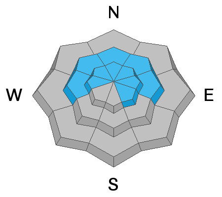
Poor snowpack structure (stronger snow over weaker snow) remains throughout the Wasatch Range. It's mainly a problem on shady slopes at the mid and upper elevations, where a slab of snow can release and fail in the weak faceted snow below. It's been about a week since our last load of snow was added to the snowpack, and the likely hood of triggering an avalanche is going down. However, it's not zero, as yesterday's slide in West Monitor demonstrated.
I get it - I see the tracks on the steep northerly terrain; it's where the best riding is. Just know that if you decide to ride steep northerly facing terrain at the mid and upper elevations, you are rolling the dice as triggering a slab avalanche 1-3' deep remains possible. A week ago, it was almost a sure thing you would trigger an avalanche. Today? Well, maybe it's a 1 out of 8 chance? I don't know... My strategy will be to avoid this steep terrain until the weak layer of faceted snow is buried so deep that it goes away or melts in the spring.
Hot Tip - Wind Drifted Snow can also add weight/load to the snowpack even though it's not snowing. We've had a lot of wind in the past four days.
Avalanche Problem #2
Wind Drifted Snow
Type
Location
Likelihood
Size
Description
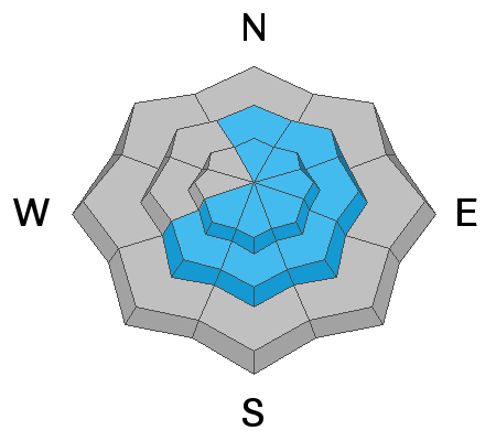
Overnight the northwest winds picked up again and are currently blowing 15-20 mph across many of the upper elevation ridgelines. There is not a ton of snow to blow around, but I am always surprised by how the wind can grab what little snow is available and move it.
The winds have been primarily from the west/northwest for the past few days. However, when winds are this strong, they can work through terrain and create drifts on almost any aspect. Fresh wind drifts often look pillowy, smooth, and rounded. Older hard drifts will feel stiff/hard and sound hollow like a drum. Any wind drifted snow avalanche that is triggered can step down deeper into weaker layers making the avalanche that much bigger.
As always, keep an eye out for drifts of windblown snow and avoid those areas.
General Announcements
Please visit this website with information about Responsible Winter Recreation by the Utah Office of Outdoor Recreation.

This information does not apply to developed ski areas or highways where avalanche control is normally done. This forecast is from the U.S.D.A. Forest Service, which is solely responsible for its content. This forecast describes general avalanche conditions and local variations always occur.