Forecast for the Salt Lake Area Mountains

Dave Kelly
Issued by Dave Kelly for
Monday, January 16, 2023
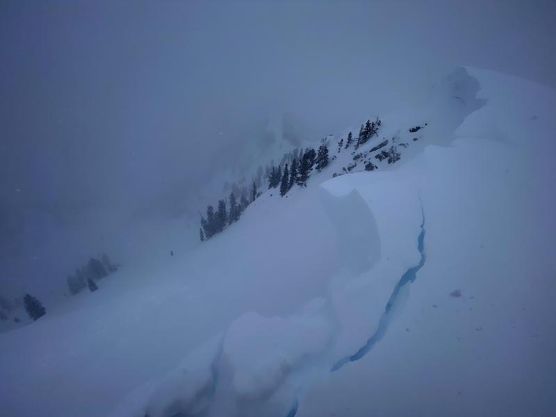
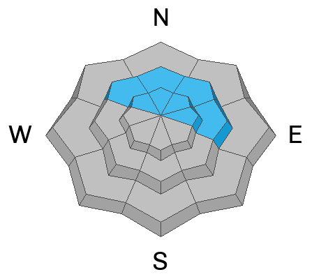
The avalanche danger is CONSIDERABLE at upper elevations, where you can expect to trigger small avalanches in the new snow on all aspects over 30 degrees. The avalanche danger is MODERATE at mid and lower elevations.

New and wind drifted snow avalanches are more than enough to catch, carry, and bury a rider.

Forecasted snowfall and increased wind this afternoon will make decision making in avalanche terrain more difficult as the day goes on.
Low
Moderate
Considerable
High
Extreme
Learn how to read the forecast here
Weather and Snow
Low density snow continues to fall in the mountains this morning. Mountain locations are reporting 2-6" of new snow overnight with light winds blowing at most locations. Trailhead temperatures are in the high teens F while the 11,000' ridgelines are in the low teens F. For today expect 1-4" snow. More snow possible later this afternoon. Under overcast skies temperatures will be 24-28 F, winds will blow from the south 20 gusting to 25 MPH at the 9,000' ridgelines and south-south easterly at the 11,000' ridgelines 25 gusting to 35 MPH.

Our partners at the National Weather Service have issued a Winter Weather Advisory from now until 5AM Wednesday morning.
Recent Avalanches
Yesterday backcountry travelers reported numerous natural and human triggered avalanches running on a density change in the new snow 8-16" deep. In steep locations with wind loading these avalanches propagated across slope and would have buried a rider.

Seeing and triggering new snow avalanches is a sign of current instability, if you continue to see new snow avalanches then BACK OFF and find a lower angle slope to travel on.

Check out the observations from yesterday HERE.
Ad
Avalanche Problem #1
New Snow
Type
Location
Likelihood
Size
Description
You will be able to trigger soft slabs and loose dry avalanches in the new snow today, particularly during periods of higher snowfall rates and on steep terrain at all aspects. It may be harder to trigger an avalanche on this layer today which could lure you out further on a slope. In my travels today I would be digging quick pits to determine if yesterday's instability 8-16" from the surface was still present and use this information to make changes to my travel plans.

The question with today's dry loose avalanches in steep terrain isn't if you will trigger an avalanche, but where will you go if there is enough snow to take you off your feet.

Check out this observation from last week of a 5" avalanche that could have had a much worse outcome if the rider had been strained through trees or pushed over a cliff band. I would expect to see similar loose dry avalanches in steep terrain today.
Avalanche Problem #2
Wind Drifted Snow
Type
Location
Likelihood
Size
Description
Today, you'll find shallow sensitive soft slabs of wind driven snow. On the surface soft slabs of wind drifted snow may crack out upon approach. At all aspects and elevations above 9,500' feet there are harder drifts of new snow that may allow you to venture further out onto them before they break. These are the places I would use caution and travel one at time into and below avalanche terrain both while ascending and descending slopes.

Cornices will be sensitive today and may break further back than you anticipate.
Cornice triggered avalanche 30' back from ridge Photo- B. Nalli
Avalanche Problem #3
Persistent Weak Layer
Type
Location
Likelihood
Size
Description
The PWL is deeply buried and it would require a significant trigger (large cornice or a powerful storm with sustained winds) to avalanche. If an avalanche breaks on this layer it would be 6-10' deep and up to 3,000' wide. An avalanche on this PWL would be very hard to trigger and un-survivable if a human was caught in a slide of this size.

You may notice us chipping away at the PWL layer in the avalanche rose. Do we think that humans will trigger an avalanche on this November PWL today. Probably not- but with new water weight and wind the PWL layer is still hanging on in the back of our minds.

The Gobbler's avalanche is still recent enough that we can't pull this PWL problem from our radar.
Additional Information
Be in the Know - follow our partners @UDOTavy for backcountry and road closure information on Twitter and Instagram.
General Announcements
This information does not apply to developed ski areas or highways where avalanche control is normally done. This forecast is from the U.S.D.A. Forest Service, which is solely responsible for its content. This forecast describes general avalanche conditions and local variations always occur.