UDOT PLANNED AVALANCHE CLOSURES!!

Forecast for the Salt Lake Area Mountains

Trent Meisenheimer
Issued by Trent Meisenheimer on
Saturday morning, January 13, 2024
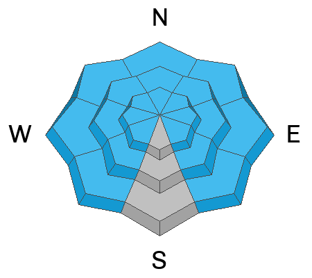
THE AVALANCHE DANGER IS HIGH, AND TRAVELING IN AVALANCHE TERRAIN IS NOT RECOMMENDED. DEADLY AND DANGEROUS AVALANCHE CONDITIONS EXIST ACROSS ALL ASPECTS AND ELEVATIONS.
Later this afternoon, the avalanche danger will likely rise to EXTREME as we expect another storm that will usher in warming temperatures, strong winds, and heavy wet snowfall.
Low
Moderate
Considerable
High
Extreme
Learn how to read the forecast here
Avalanche Warning
The avalanche danger for the warning area is HIGH for the mountains of northern and central Utah and southeast Idaho, which includes the Wasatch Range...the Bear River Range...Uinta Mountains...Manti-Skyline plateau...and the Mountains of Southwestern Utah.
Strong winds and heavy snowfall have created dangerous avalanche conditions. Avalanches failing on a widespread persistent weak layer buried under the new snow are very likely. Stay off of and out from under slopes steeper than 30°.
This avalanche warning is in effect from Saturday, January 13, 2024 - 6:00am to Sunday, January 14, 2024 - 6:00am
Weather and Snow
The National Weather Service has issued a Winter Storm Warning for the mountains of northern Utah. Overnight, we picked up another 5-10 inches of new snow containing 0.4-1.06" water, bringing storm totals since Tuesday to roughly 30-45 inches of new snow with 2.0-3.16 inches of water. Northwest winds were the main headline overnight, with speeds averaging 60-70 mph and four gusts over 100 mph at 11,000'. It's avalanche weather!
This morning, it continues to snow. Mountain temperatures are in the single digits °F. Winds are blowing from the northwest at speeds of 20-30 mph, gusting into the 40s across most upper-elevation terrain. At 11,000', winds blow northwest at 60-70 mph, gusting into the 90s.
Today, we will continue to see cold temperatures, strong winds, and heavy snowfall. Later this afternoon, the storm will juice up once again with warm air advection, bringing heavier snowfall on a westerly flow. Throughout the day today, we could see an additional 4-8 inches of new snow. Overnight Saturday into Sunday morning, we could see an extra 12-24 inches of new snow. By Monday morning, storm totals could be 3-5 feet (3.0-4.0 inches of water weight).
Recent Avalanches
Yesterday, there were another 14 avalanches reported to the Utah Avalanche Center. Two of these were people caught and carried, with one of those people fully buried in an avalanche in Main Porter Fork in Millcreek Canyon. Luckily, they could locate and dig out the person with no injuries.
The other catch and carry ended with a partial burial. This was a second-hand report from Greens Basin in Big Cottonwood Canyon. Most, if not all, of these avalanches were 2-4 feet deep and hundreds of feet wide, failing on a persistent weak layer.
Large and dangerous natural avalanches have also happened and will continue to occur throughout the day today. Be sure to check all the avalanche activity HERE.
Ad
Avalanche Problem #1
Persistent Weak Layer
Type
Location
Likelihood
Size
Description
STRONG WINDS AND HEAVY SNOWFALL HAVE OVERLOADED ALL STEEP AVALANCHE-PRONE TERRAIN. To make matters worse, we have a widespread buried persistent weak layer that makes these avalanches even more dangerous. Tree snapping, bone-crushing, deadly avalanches 2-5 feet deep and hundreds of feet wide are very likely to be triggered by humans. Natural avalanches will also be roaring down from above and will travel long distances, slamming into the valleys below.
This is one of the more dangerous times I can remember in my career. There is no outsmarting this problem. Please take these avalanche conditions seriously and AVOID being in or under any avalanche terrain (slopes steeper than 30 degrees) throughout the weekend.
General Announcements
This information does not apply to developed ski areas or highways where avalanche control is normally done. This forecast is from the U.S.D.A. Forest Service, which is solely responsible for its content. This forecast describes general avalanche conditions and local variations always occur.