Check Out Our Holiday Auction!

Forecast for the Salt Lake Area Mountains

Drew Hardesty
Issued by Drew Hardesty on
Wednesday morning, December 10, 2025

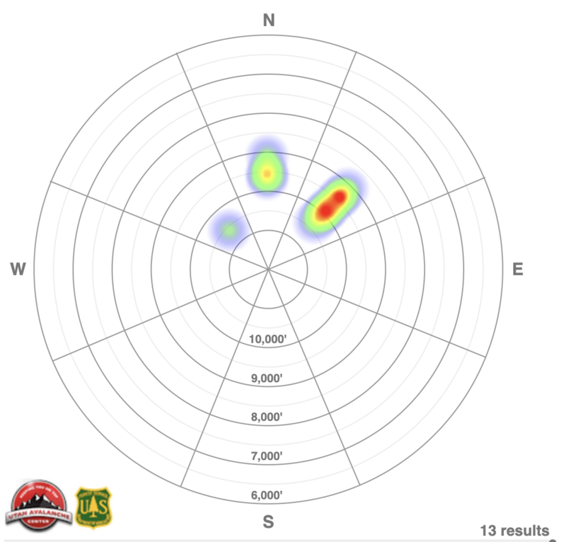
A MODERATE avalanche danger exists on steep west to north to east facing slopes above about 9000 feet for triggering a 1-2 foot thick slab that fails on our old Oct/Nov facets. Collapsing and cracking are sure give-aways to site specific instability...but these signs are becoming less common. Due to their tricky nature, I am still avoiding steep terrain with this structure. You can also trigger the isolated and stubborn slab of wind blown snow in the mid and upper elevations today but note these slabs can be found in unusual spots.

It may not be too early to mention the potential for wet loose avalanches. Watch for rollerballs as hints to choose different aspects.

Low
Moderate
Considerable
High
Extreme
Learn how to read the forecast here
Weather and Snow

Storms are afoot, but not for us. The plumes of moisture are targeted directly at the Cascades, northern Idaho and Montana. Not to have sour grapes, but I hope their rain line stretches to 10,000'. It won't be that, but it might be close. See the European model depicting total precipitation through Sunday, below.

We have mostly cloudy skies to start the morning with unseasonably warm mountain temperatures. Overnight "lows" up high were just shy of freezing while "lows" down low were in the upper 30s to 40 degrees. Skies will trend partly cloudy today with moderate to strong winds from the northwest. Daytime highs will reach into the mid-30s up high, the mid-40s down low. It's unsettling to see forecast temps in the valley today to reach 60°F and forecast ridgetop temperatures this weekend spiking to the mid-40s. And from where I'm sitting, no storms until the Solstice. We'll see. To paraphrase Borges, There is no reason to create fictions of absurdity because the Universe already exists.

Skiing and riding conditions will be, uh, rugged this morning with a breakable crust on all aspects and even on true north as high as 9500'. These crusts will soften with daytime warming and thinning cloud cover, but you won't see Lee Cohen snapping powder photos today. Or probably anytime soon. Coverage in the upper Cottonwoods is 1-2 feet up high and dirt to 10 inches at the trailheads. The PC ridgeline hosts 12-18 inches up high.

Recent Avalanches

There were no new avalanches reported from the backcountry yesterday, although we did get reports of avalanche teams triggering spotty (they specifically used the term "sneaky") soft slabs of wind blown snow. The last reported avalanche that failed on the old Oct/Nov facets was on Sunday. A rough heat map of these slides is below.

Avalanche Problem #1
Persistent Weak Layer
Type
Location
Likelihood
Size
Description

A persistent weak layer (PWL) of October and November facets makes up the base of the snowpack on west-north-east facing slopes at the mid and upper elevations. In these areas, it is still possible to trigger an avalanche up to about 2 feet deep and over 100 feet wide.

This setup was obvious over the weekend, with widespread avalanche activity and plenty of red flags. As we move farther from the loading event, those signs may be less obvious, but the structure has not changed. Sensitivity and overall likelihood are slowly dropping, but the consequences remain high. Cracking and collapsing of this weak layer was noted in the upper Cottonwoods as recently as yesterday.

Pull out your shovel and the poor snowpack structure is obvious. Note the consolidated slab over the 'rock salt' facets at the base of the snowpack.

Avalanche Problem #2
Wind Drifted Snow
Type
Location
Likelihood
Size
Description

The west to northwest winds have been cranking for days. And while there is little snow available for transport and time and warmth are helping weld these wind slabs onto the landscape, you might still trigger pockety hard or soft slab in (see above) "sneaky" terrain. Caution should still be observed in wind drifted terrain.

General Announcements

This information does not apply to developed ski areas or highways where avalanche control is normally done. This forecast is from the U.S.D.A. Forest Service, which is solely responsible for its content. This forecast describes general avalanche conditions and local variations always occur.