Yesterday, sustained moderate to strong winds out of the SW continued to blow, while there wasn't a ton of fresh precipitation to transport (as it mostly fell as rain) except for at upper elevations in the Provo zone.
Today, a weather system moves in on SW flow later this afternoon. Temps remain just below freezing, along with assistance from the SW winds that will increase to moderate to strong today. The moisture arrives later this afternoon, with snow lines starting around 8k' before dropping closer to 6.4k' overnight. "Timing is everything," I think is how the saying goes, but it's notoriously hard to forecast. The crystal ball this morning is showing things play out as so, with less certainty the farther out:
- Provo Peak area: 0.4-0.6 inches snow // 0.1-0.2 inches H2O by 5pm —— 4-6 inches snow // .4-.6 inches H2O by 8am Monday
- Aspen Grove area: 0.5-0.7 inches snow // 0.2-0.3 inches H2O by 5pm —— 10-13 inches snow // 1.5-1.9 inches H2O by 8am
Late tonight into tomorrow, the bulk of the moisture arrives. Snowfall will linger Monday afternoon until tapering into the evening. Winter seems to be arriving, as more colder systems inch towards us later next week. Cross your fingers, and keep checking the often more hopeful model, the GFS—or as we sometimes call it: the Great Friend of Skiers.
Yesterday, there were no new avalanche reports from the backcountry. Provo has been generally quiet the last few days.
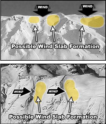
In the Central Cottonwoods, Ski patrol teams reported a wet snow surface at the lower elevations of their mountains, allowing for easy push avalanches, or snow pushing on the supportable crust, along with one report of an explosive-triggered soft slab. Observations also noted sensitive wind-drifted snow at upper elevation ridgelines.
Find all the Provo observations HERE.