Join us at our 2nd Annual Blizzard Ball

Forecast for the Provo Area Mountains

Mark Staples
Issued by Mark Staples on
Thursday morning, April 1, 2021
Welcome to April! Don't expect April Fools' jokes from us, but have fun and watch for wet avalanches today.
The avalanche danger today will rise to MODERATE as temperatures quickly warm and the snow becomes wet. Expect wet loose avalanches which may be human triggered, or they may happen naturally. They will mostly occur on slopes receiving direct sunshine, but watch how much the snow is becoming wet on other slopes where these avalanches could happen as well.
Low
Moderate
Considerable
High
Extreme
Learn how to read the forecast here
Special Announcements
Thank you to everyone who helped make our Spring Campaign a huge success. We are grateful for your support and look forward to continuing to serve you with forecasting, education, and awareness programs in new and exciting ways.
Weather and Snow
This morning temperatures are hovering near or just above freezing which is fifteen degrees warmer than yesterday morning at 4 a.m. Light southerly winds are blowing 2-6 mph with gusts up to 20 mph at the highest ridgelines.
Today will be warm and sunny. High temperatures in many places will climb above 40 degrees F. Southerly winds this afternoon may increase a little.
The snow this morning should be refrozen from a combination of below-freezing air temperatures and clear skies.
Recent Avalanches
Yesterday the snow barely warmed and softened, and there were no reports of avalanches.

As always, find all recent observations and avalanches HERE.
Ad
Avalanche Problem #1
Wet Snow
Type
Location
Likelihood
Size
Description
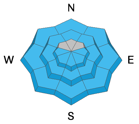
Instead of a snow storm, think of today as the start of a solar storm of sunshine and heat. This heat will cause the snowpack to melt, lose cohesion, and produce wet loose avalanches. A slide further south in Big Cottonwood Canyon on Mt. Raymond is a good example of what to expect today. The good news is that these slides are generally predictable and start very small at your feet. The main concern is having a naturally triggered slide come down onto you especially if you are in a gully, couloir, or other confined terrain where avalanche debris can pile up deeper.

Slopes receiving direct sunshine should have plenty of predictable, small, wet loose avalanches today. They will start happening as the snow becomes wetter and wetter and you see clues like other slides or more and more snowballs rolling downhill. Even slopes facing north at mid and low elevations should have some wet avalanche activity. I worry more about these slopes because I'm unsure how they will react. They have experienced melting and refreezing in the top few inches of snow, but still have dry snow underneath which should start to become wet today and even more this weekend.
General Announcements
Please visit this website with information about Responsible Winter Recreation by the Utah Office of Outdoor Recreation.

This information does not apply to developed ski areas or highways where avalanche control is normally done. This forecast is from the U.S.D.A. Forest Service, which is solely responsible for its content. This forecast describes general avalanche conditions and local variations always occur.