All four final avalanche accident reports (Caribou Basin, Butler Basin, Lake Mary Chutes, and Ant Knolls) have now been published. These are reports of four avalanche fatalities in five days spanning February 18th-February 22nd. You can find them all HERE>
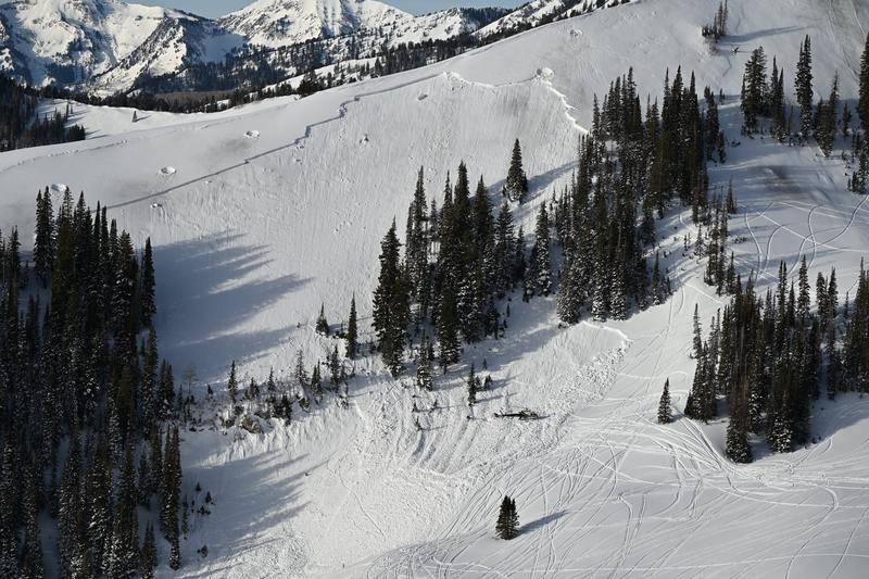
Drone footage of the Caribou avalanche after avalanche control work had been conducted to reduce the risk to the SAR teams.
Thank you to everyone involved for sharing information. As with all avalanche accidents, we hope to learn something to prevent future accidents. Our deepest condolences go out to the families, friends, rescuers, and everyone affected by these tragic accidents.
Skies are clear. But not for long: we have a classic Wasatch storm on tap for tonight through late Friday.
Temps are in the upper 20s; winds - hardly a whisper yesterday - have increased out of the south-southwest and are blowing 10-15mph with gusts to 20. The high anemometers have hourly averages now in the 20s.
For today, we'll see increasing clouds, elevating winds, and temps again rising into the upper 30s up high, the 40s down low. A strong cold front arrives overnight, accompanied by heavy snowfall and plummeting temperatures. There is some chance of the lake effect kicking in and my overall storm totals are roughly 6-12"+ with an inch of water by later Friday. Our partners at the SLC National Weather Service have issued a Winter Storm Watch.
The Outlook: Some clearing for the weekend, with an somewhat active pattern for next week. The longer range models aren't in much agreement, so we'll see...
We didn't hear of any activity in the backcountry yesterday, but in the southern part of the central Wasatch, numerous wind slabs and wet loose avalanches were noted.

Large natural wind slab noted off the American Fork Twins at roughly 11,000' southeasterly facing...