Join us at our 2nd Annual Blizzard Ball

Forecast for the Provo Area Mountains

Drew Hardesty
Issued by Drew Hardesty on
Tuesday morning, March 28, 2023
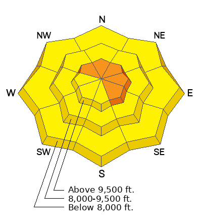
Areas of CONSIDERABLE avalanche danger exist on steep wind drifted slopes. This danger will be most pronounced on upper elevation northwest to east to southeast facing terrain. A MODERATE danger exists for triggering soft slab avalanches 1-2' deep on all other aspects and elevations. Natural cornice fall and roof-alanches are likely today.
Pay close attention to the sun and warming temperatures. The wet avalanche danger may rapidly increase today on all solar aspects and even low elevation northerly slopes.
Low
Moderate
Considerable
High
Extreme
Learn how to read the forecast here
Special Announcements
We are in the process of finalizing a report about the March 9th avalanche fatality in the Uintas. Thank you for your patience, and we will publish the final report in coming days.
Thank you to everyone who donated to our Spring Campaign. We appreciate your support and look forward to creating new tools to help you stay safe in the backcountry.
Weather and Snow
Skies are partly cloudy.
Mountain temperatures are in the teens.
Winds, again, play the spoiler. Ahead of this next Pacific storm, winds out of the southwest have increased, blowing 25-30mph with gusts to 40. The highest ridgelines are gusting to near 70mph.
For today we'll have periods of sun with alternating high and mid-level clouds drifting through. Mountain temperatures rise into the upper-20s up high, the upper-30s (or more) down low. Winds will be moderate to strong out of the southwest.
Wind and sun damage now exist in exposed terrain, but soft settled powder can be found in the sheltered shady slopes.
The Outlook: Yet another powerful Pacific storm is on deck. We'll see increasing clouds and southwest winds today, tonight and tomorrow ahead of at-times heavy snowfall Wednesday night through Friday. 1-2' of new snow may be expected.
Recent Avalanches
Two large natural avalanches released on the south flank of Timpanogos yesterday. These were roughly 2' deep with another one estimated at 4-7' deep. These were on steep east facing slopes at about 9900' and mostly likely triggered by the strong wind transport in the morning.
Ad
Avalanche Problem #1
Wind Drifted Snow
Type
Location
Likelihood
Size
Description
Hard to catch a break with the wind drifting. With yesterday's west to northwest winds and this morning's south to southwest winds, you'll find myriad soft slabs of wind drifted snow all around the compass. NOTE that these soft slabs will be most prevalent on northerly to easterly aspects and well off the ridgelines. Shooting cracks and perhaps collapsing are good indicators of instability. It may be possible to trigger these (remotely) at a distance.
Avalanche Problem #2
New Snow
Type
Location
Likelihood
Size
Description
Loose snow and soft slab avalanches in the storm snow can (and will) be triggered in steep terrain of all elevations today and honestly, the snowpack is more rich, complex, and interesting than I want it to be right now.
Avalanches may fail within the new snow or at the new snow/old snow interface (2-4' down) as we saw near the Ant Knolls on Saturday. It has also been reported that some new snow avalanches have then stepped down to this older interface from last week.
I plan to stick to low angle slopes until the snowpack stabilizes. If you're seeking steeper terrain, choose terrain that won't kill you if you've made a mistake.
Avalanche Problem #3
Wet Snow
Type
Location
Likelihood
Size
Description
The wild card: It's almost April, and that sun is strong. Any periods of strong sunshine could instantly spike the avalanche danger, and wet snow avalanches could run. Increasing high level clouds may foster greenhousing, and subsequently, low elevation northerly aspects may become damp and unstable. Fortunately, you'll be able to gauge this - if/when the snow becomes damp and you start seeing rollerballs and sluffing, choose low angle terrain.
General Announcements
This information does not apply to developed ski areas or highways where avalanche control is normally done. This forecast is from the U.S.D.A. Forest Service, which is solely responsible for its content. This forecast describes general avalanche conditions and local variations always occur.