Forecast for the Provo Area Mountains

Drew Hardesty
Issued by Drew Hardesty for
Monday, March 27, 2023
Areas of CONSIDERABLE avalanche danger exist in the upper elevations. Human triggered avalanches will be likely, particularly on steep north to east to south facing slopes.
Heavy snowfall and strong winds over the past few days have created a layered and conditionally unstable snowpack on all aspects and elevations. Caution is essential today on all aspects and elevations.
Low
Moderate
Considerable
High
Extreme
Learn how to read the forecast here
Special Announcements
We are in the process of finalizing a report about the March 9th avalanche fatality in the Uintas. Thank you for your patience, and we will publish the final report in coming days.
Thank you to everyone who donated to our Spring Campaign. We appreciate your support and look forward to creating new tools to help you stay safe in the backcountry.
Weather and Snow
Would you believe me if I told you it was still snowing?
The Provo mountains picked up 6-8" overnight combined with moderate to strong west to southwest winds.
Mountain temperatures are in the teens.
We should be seeing "peak" snowfall and winds this morning. We'll start to dry out (if only for a day or two) and possibly see a touch of blue by afternoon. Winds will lose steam and average 15mph along the 10k ridgelines.
Tuesday will be a bit of a break ahead of the next prolonged storm system that will bring at-times heavy snowfall Wednesday afternoon through Friday. 1-2' can be expected. The next storm is forecast for late weekend.
Recent Avalanches
On 
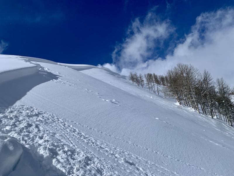
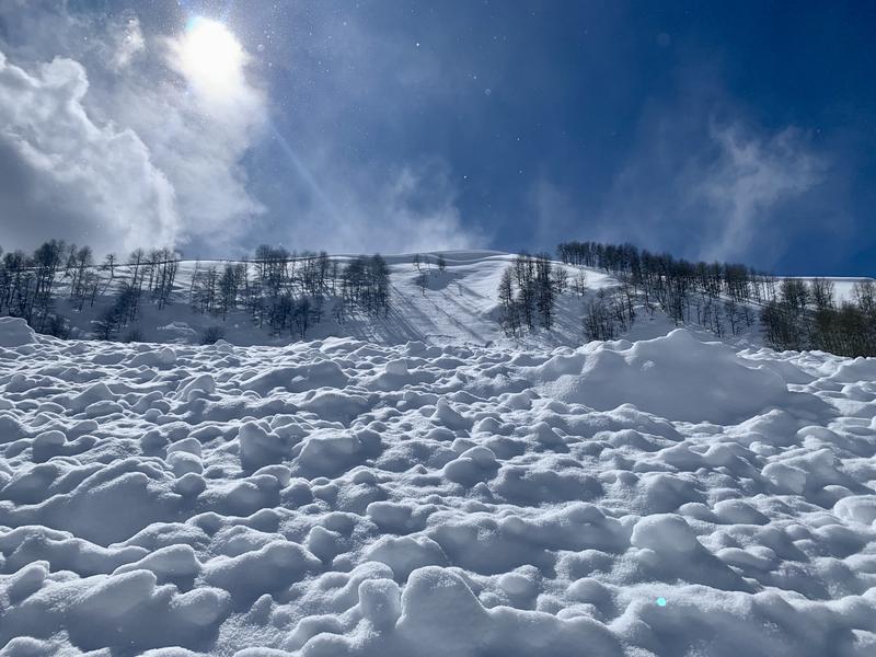
Saturday, a snowmobile remotely triggered a significant avalanche just south of the Ant Knolls in upper Snake Creek (above Heber/Midway). (pics 1, 2) This avalanche ripped out 2' deep and 700' wide on a steep easterly facing slope at 9400', failing on a thin layer of surface facets, and buried by the mid-week storm(s). It left large debris piles and barely overran the groomed Cummings Parkway track below. What is troubling is that this was the only avalanche I noted in the vicinity; that I experienced no cracking or collapsing, and snow tests did not necessarily send a bunch of red flags. Also on Saturday, another skier remotely triggered a fresh soft slab of wind drifted snow nearby 10" deep, propagating 250' down the ridgeline.
How should this affect terrain choices for today?
Ad
Avalanche Problem #1
Wind Drifted Snow
Type
Location
Likelihood
Size
Description
New and old soft slabs 1-2'+ deep of wind drifted snow can be triggered in steep terrain today, particularly on steep north to east to south facing slopes at the mid and upper elevations. Long time and trusted backcountry observer Andy Paradis well described the situation yesterday, "Today's snow plus multiple different loading directions created sort of a complex snowpack that is not visually obvious." It'll be key to avoid recently wind drifted slopes today.
Avalanche Problem #2
New Snow
Type
Location
Likelihood
Size
Description
It just keeps snowing.
Loose snow and soft slab avalanches in the storm snow can (and will) be triggered in steep terrain of all elevations today and honestly, the snowpack is more rich, complex, and interesting than I want it to be right now.
Avalanches may fail within the new snow or at the new snow/old snow interface (2-4' down) as we saw near the Ant Knolls. It has also been reported that some new snow avalanches have then stepped down to this older interface from last week.
Weak snow also exists along the interface of a rain crust in the mid and low elevations. DO NOT discount unstable snow in these 'lower' elevation bands. Cracking and collapsing are keys to instability.
I plan to stick to low angle slopes until the snowpack stabilizes. If you're seeking steeper terrain, choose terrain that won't kill you if you've made a mistake.
General Announcements
This information does not apply to developed ski areas or highways where avalanche control is normally done. This forecast is from the U.S.D.A. Forest Service, which is solely responsible for its content. This forecast describes general avalanche conditions and local variations always occur.