Join us at our 2nd Annual Blizzard Ball

Forecast for the Provo Area Mountains

Dave Kelly
Issued by Dave Kelly on
Friday morning, March 24, 2023
The avalanche danger is CONSIDERABLE on mid and upper elevation slopes where natural new snow slab, wind-drifted avalanches, and loose dry sluffs are possible and human triggered avalanches are likely. Periods of increased snowfall throughout the day have the potential to increase the avalanche hazard to HIGH if forecasted snowfall amounts pan out. Low-elevation slopes have a MODERATE avalanche danger, where there has been less snow and lighter winds.

Assessing changing conditions within the new and wind-drifted snow could mean the difference between a great day in the mountains and a close call. Luckily, lower angle storm skiing will be great all day long!
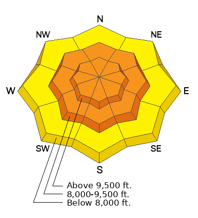
Low
Moderate
Considerable
High
Extreme
Learn how to read the forecast here
Special Announcements
We are in the process of finalizing a report about the March 9th avalanche fatality in the Uintas. Thank you for your patience, and we will publish the final report in coming days.

Thank you to everyone who donated to our Spring Campaign. We appreciate your support and look forward to creating new tools to help you stay safe in the backcountry.
Weather and Snow
This morning, under overcast skies temperatures are in the mid-20's ˚F. Winds are blowing from the southeast at the trailheads and south-southwest 15 gusting to 30MPH at the 8,000' ridgelines. Overnight 3" of new snow fell. Storm totals range from 11-16" of snow with 1-2" of water weight. This storm has been a continued event and the size of the avalanches has only creeped up as the days have gone on. I would imagine that today's avalanches will be slightly bigger than yesterdays.

For today, we are looking at overcast skies with 4-8" of new snow forecasted. Temperatures will be 26-30 ˚F with winds blowing west-northwest 20 gusting to 40 MPH. Look for increasing winds and decreasing temperatures throughout the day as the storm makes its way across Northern Utah. There is a chance of lightning this afternoon.

Our partners at the National Weather Service have issued a Winter Storm Warning in effect until noon on Saturday March 25.
Recent Avalanches
Yesterday we had 6 reported backcountry rider triggered avalanches within the new and wind-drifted snow.

Find all the recent observations HERE.
Ad
Avalanche Problem #1
New Snow
Type
Location
Likelihood
Size
Description
Increased snowfall rates will raise your chance of triggering a soft slab avalanche 1-2' deep and failing on a density change in the top layers of the snowpack.
When the snowfall rates are greater than 1" per hour, avalanches will be easier to trigger, and more likely to act as a cohesive slab. Signs of instability like cracking, and collapsing mean it's time to let the new snow settle out before committing to steep terrain.
Avalanche Problem #2
Wind Drifted Snow
Type
Location
Likelihood
Size
Description
Winds will move snow around and continue to form drifts that may avalanche 1-2' deep and 100-150' wide. These slabs will be most pronounced on leeward-facing slopes. New snow will make it difficult to identify signs of wind-drifting.

CORNICES are not to be messed with. Limit your exposure to ridgelines near cornices, and slopes below cornices. A cornice fall could trigger a larger slab of wind-drifted snow below.
Additional Information
Forecaster's Corner:
What does Acceptable Risk even mean?
Through an avalanche accident earlier this winter, Drew has been able to put together a clear example of what he believes defines acceptable risk. Read more on this HERE.
General Announcements
This information does not apply to developed ski areas or highways where avalanche control is normally done. This forecast is from the U.S.D.A. Forest Service, which is solely responsible for its content. This forecast describes general avalanche conditions and local variations always occur.