Forecast for the Provo Area Mountains

Drew Hardesty
Issued by Drew Hardesty for
Monday, March 20, 2023
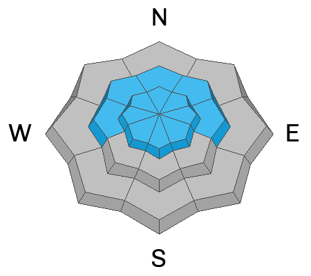
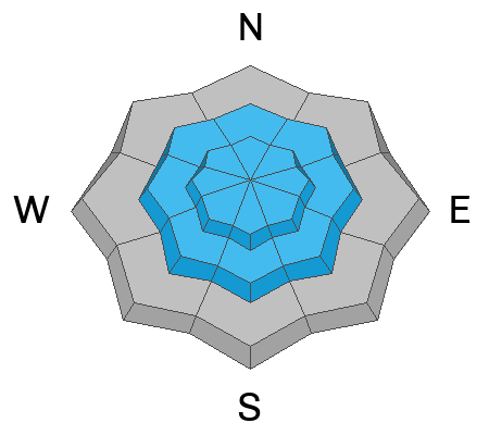
The avalanche danger is CONSIDERABLE in the upper elevations and MODERATE in the mid and low elevations.
You'll be able to trigger both soft slabs and loose dry new snow avalanches as well as lingering and developing slabs of wind drifted snow up high. New snow avalanches are particularly sensitive during any periods of high and sustained rates of snowfall.
Low
Moderate
Considerable
High
Extreme
Learn how to read the forecast here
Special Announcements
Please consider donating to the spring campaign to help our team implement innovative tools to better provide you with the information you rely on.
Weather and Snow
Happy first day of spring.
We have a fairly active week with weather. This first impulse has already brought 6-8" of snow in the Provo mountains with rain down low. Mountain temperatures are in the mid to upper-20s. Winds are moderate out of the southwest.
For today, we'll see continued snowfall - perhaps 4-8" during the day. Winds will veer to the west and be gusty along the highest ridgelines during and just after frontal passage this afternoon.
We get a bit of a break tomorrow ahead of another potent storm Tuesday night into early Friday. We may see as much as 25-35"+ of snow with this system. The weather pattern remains active for the weekend into next week.
Recent Avalanches
None reported in the Provo area mountains yesterday. In the SLC mountains yesterday: a natural cornice fall triggered a 14" deep and 100' wide soft slab of wind drifted snow on a steep north facing slope at 9700'.
In Boulder Basin of upper White Pine, a skier triggered a hard slab of wind drifted snow on a 28° slope that was connected to a steeper slope. It broke 18" deep and 200' wide.
Ad
Avalanche Problem #1
Wind Drifted Snow
Type
Location
Likelihood
Size
Description
You'll still be able to trigger lingering soft and hard slabs of wind drifted snow from Saturday/Sunday, primarily in the mid and upper elevation bands, and predominantly on the north side of the compass. Note that these 1-2' thick slabs can be found well off the ridgelines and on mid-slope breakovers. Watch for developing soft slabs of wind blown snow today to the lee of ridgelines and terrain features in the mid and upper elevations. You may be able to trigger these at a distance.
CORNICES are not to be messed with. They are as big as I can remember and they can crush a skier or rider that either falls over the edge with one.....or crush a skier or rider below.

  • For more thoughts on our current setup, click HERE.
Avalanche Problem #2
New Snow
Type
Location
Likelihood
Size
Description
Loose dry sluffs in the new snow can be triggered in steep terrain of all aspects in the mid and upper elevations...and may run naturally during periods of higher snowfall rates. I suspect they'll run fast and far on the underlying bed surfaces of slick sun and wind crusts or loose faceted grains. More info on sluffs and sluff management.
  • Shallow soft slabs within the new snow may also be triggered in steep terrain. It's currently snowing hard in the Provo mountains and the forecast is for periods of higher snowfall this afternoon.
  • Wet avalanches are possible at and just below the rain/snow line.
General Announcements
This information does not apply to developed ski areas or highways where avalanche control is normally done. This forecast is from the U.S.D.A. Forest Service, which is solely responsible for its content. This forecast describes general avalanche conditions and local variations always occur.