Forecast for the Provo Area Mountains

Trent Meisenheimer
Issued by Trent Meisenheimer for
Thursday, March 14, 2019
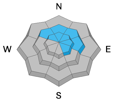
The avalanche hazard remains at CONSIDERABLE at the mid and upper elevations facing northwest through southeast where a complex pattern of weaker buried layers of snow remain. There is a MODERATE hazard of fresh drifts and storm snow at the upper elevations, as well as north-facing mid elevations.
The avalanche danger could spike immediately to CONSIDERABLE on sunny slopes if the sun decides to come out this afternoon.
Low
Moderate
Considerable
High
Extreme
Learn how to read the forecast here
Weather and Snow
Under mostly cloudy skies this morning the temperatures remain cold with upper elevations in the single digits to low teens °F across the board. Winds are from the northwest and are currently blowing 10-15 mph gusting into the low 20's across the upper peaks. Mid elevations the winds are calm. By mid to late morning we will see some clearing with the possibility of full sunshine by late afternoon. The good news: 700mb (10,000') temperatures will remain cold throughout the day, climbing into low teens °F by late afternoon/evening.
Snow totals are dismal compared to Provo's northerly neighbor. Totals are roughly 3-6" of new snow (0.2-0.42" h20)
Recent Avalanches
No new observations were reported for the Provo area.
Ad
Avalanche Problem #1
Wind Drifted Snow
Type
Location
Likelihood
Size
Description
North/northwest winds have created pockets of fresh drifts at the upper elevations. Although, these will primarily be found on southerly and easterly aspects, cross-loading will make it possible for drifting on any aspect. These drifts will generally be 6-12" thick.
We only had small amounts of new snow, however, sluffing in the new snow is possible, especially on steeper northerly aspects where drier old snow was preserved.
Avalanche Problem #2
Persistent Weak Layer
Type
Location
Likelihood
Size
Description
The Provo snowpack remains dangerous on many aspects and elevations, with a complexity that makes it difficult to identify patterns. Field reports from Tuesday indicated persistent weak layers are still reactive to stability tests, and this is enough for very experienced people to continue to provide a wide buffer of margin in this terrain. These are difficult and dangerous conditions to assess - from Cascade to Box Elder to Timp to the southern Wasatch Back (Snake Creek to Mill Canyon Peak).
Avalanche Problem #3
Wet Snow
Type
Location
Likelihood
Size
Description
This will be the wild card today!!! it's March and the sun is strong. If we see any clearing this morning or afternoon you can expect the steep sunlit slopes to immediately become damp and start producing natural wet loose avalanches. The loose wet snow could pack a punch as much of the southerly facing terrain has slick crusts for it to run on. Keep an eye to the sky and watch the snow surface. If you're seeing roller balls or small point release avalanches on any aspect - it's time to leave or ride in terrain that's under 30° degrees with nothing steep above or adjacent to you.
Think about your exits today - if your exit is a steep gully or drainage you'll want to give yourself plenty of time to safely pass through if the sun comes out.
General Announcements
This information does not apply to developed ski areas or highways where avalanche control is normally done. This forecast is from the U.S.D.A. Forest Service, which is solely responsible for its content. This forecast describes general avalanche conditions and local variations always occur.