Join us for the 17th Annual Professional Snow and Avalanche Workshop (PROSAW) on November 4 - Purchase tickets here!

Forecast for the Provo Area Mountains

Nikki Champion
Issued by Nikki Champion on
Sunday morning, February 18, 2024
The avalanche danger is CONSIDERABLE on all slopes across the upper elevations, where strong winds and new snow have created dangerous avalanche conditions, and it remains possible to trigger a hard slab avalanche breaking 4-6 feet deep on a deeply buried persistent weak layer of faceted snow. The mid-elevation slopes that received generally less wind and snow have a MODERATE danger.
Any avalanches, wind-drifted snow, or new snow may be more sensitive today due to weak grains at the new snow, old snow interface, particularly on aspects with a southeasterly or easterly direction. Careful snowpack evaluation, cautious route-finding, and conservative decision-making will be essential today.
If the sun comes out this afternoon, the snow surface could heat up, and we could begin seeing small wet-loose avalanches on solar aspects. Remember, even "smaller" slides can be dangerous in high-consequence terrain.
Low
Moderate
Considerable
High
Extreme
Learn how to read the forecast here
Special Announcements
We are seeking a passionate individual to join us as Executive Director of the nonprofit Utah Avalanche Center. Click here for more information.
Weather and Snow
This morning, snow has begun falling in the mountains with no measurable precipitation as of 5 AM. Temperatures range from the upper teens to the mid-20s °F. Winds are primarily from the west, blowing at 10-20 mph, with gusts up to 30 mph at mid-elevations. At the highest elevations, winds have been gusting up to 60 mph. Winds have progressively increased since yesterday afternoon and evening, remaining elevated most of the night.
Today, snowfall will decrease from moderate to heavy this morning, changing to showers by noon. Snowfall totals are expected to be between 2.5-6.5" of new snow, with peak snowfall rates up to 1.5" an hour. Winds will peak around sunrise and then decrease slightly throughout the day, averaging 10-20 mph at mid-elevations, with gusts up to 30 mph. At the highest elevations, winds could gust up to 60 mph. By mid-afternoon, the snow will stop, and skies will become mostly sunny with temperatures climbing into the mid-30s °F.
Extended: After a break tonight into Monday morning, expect intermittent snow chances from late Monday to early Thursday, with the main snowfall expected on Wednesday.
Recent Avalanches
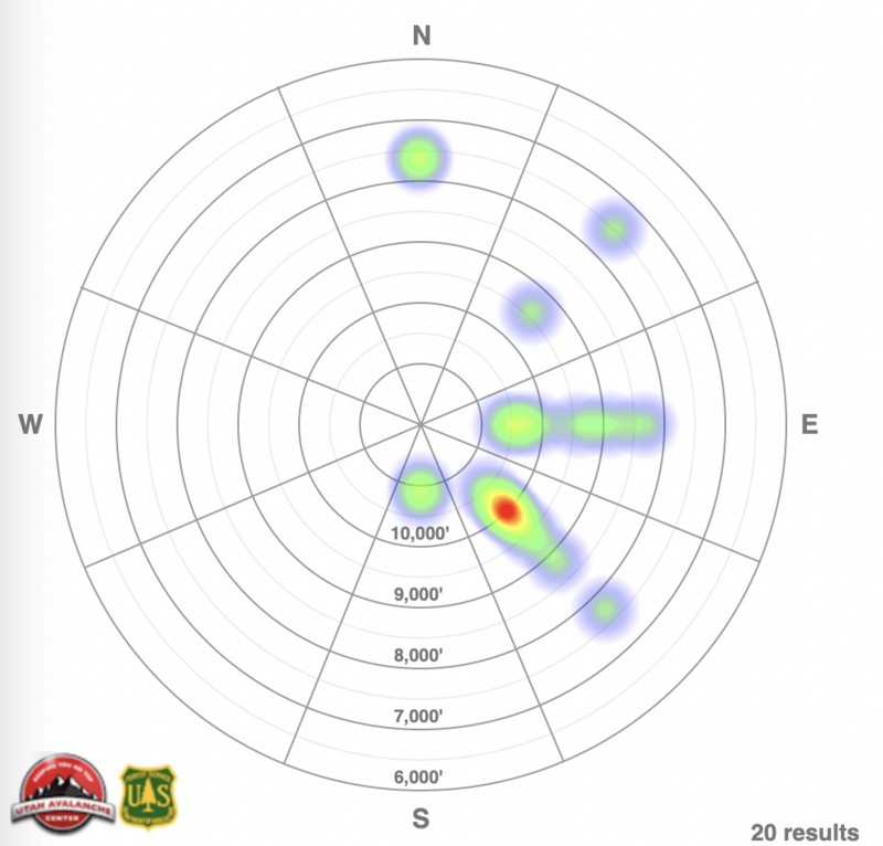
Yesterday was a busy day in the backcountry, with about 20 avalanches reported in the Salt Lake, Ogden, and Provo area mountains since Friday. The majority of these avalanches failed as soft slabs of new snow or wind-drifted snow, occurring within a density inversion in the storm snow or at the interface with the old snow surface, particularly on solar aspects that had previously been exposed to sunlight. These areas now have a firm melt-freeze crust with weak stellars or faceted grains at the interface between the new and old snow. The focal aspect seems to be southeast, as demonstrated by the three separate avalanches on Superior, the avalanche off of the Three Temptations (photo below), and the countless other observations that were reported. This aspect appears to be holding both the melt-freeze crust and some weak grains at the interface. Most of these avalanches broke 10"-2' deep and were anywhere from 40'-250' wide.
Temptations - 9400' - East Aspect - Z. Hodgson - Find the full observation HERE.
With so many recent avalanches pouring in, it's hard to write about each one individually, but it's worth reading about them before heading into the field today. You can find all of the recent avalanches on our website.
Avalanche heatmap for the Salt Lake, Provo, and Ogden area mountains for 2/16-2/18.
On Thursday, one Cottonwood resort reported a natural avalanche that broke into old, faceted snow on a northwest aspect at 10,600 feet.
Ad
Avalanche Problem #1
Wind Drifted Snow
Type
Location
Likelihood
Size
Description
With strong winds overnight and fresh snow, sensitive slabs of wind-drifted snow are likely to be encountered on all upper-elevation slopes and mid-elevation terrain features that allow for drifting snow accumulation. These drifts could be 6-24 inches deep and up to 150 feet wide. Watch out for signs of wind-drifted snow, such as pillow-shaped deposits, and avoid those slopes.
Any avalanches, wind-drifted snow, or new snow may be sensitive today due to weak grains at the new snow, old snow interface. The Valentine's Day storm buried facets, weak stellars, and surface hoar on many slopes. On Friday, Drew headed to 10,420' to investigate this layer and found weak snow on almost all aspects. While this layering was evident on north-facing slopes, there were no observed signs of cracking or collapsing. However, on east-facing slopes, collapsing was apparent, mainly due to facets and small-diameter surface hoar associated with a buried 2cm melt-freeze crust. Drew's findings, as well as all the overwhelming avalanche activity yesterday, let us know that the southeasterly and easterly facing terrain is the current bulls-eye terrain for this issue. Due to this weak interface, remote triggering an avalanche from a distance remains possible.
It's expected that this layering will settle in a few days but could remain active under any stress, whether from wind or snow today. If this layer does not settle out, we would expect to see it transitioning away from an interface issue and into a more traditional persistent weak layer instability.
Avalanche Problem #2
New Snow
Type
Location
Likelihood
Size
Description
This morning's storm is expected to bring 2.5-6.5 inches of new snow. Anticipate shallow new snow avalanches in the backcountry as the snow totals increase, especially in areas outside the wind zone that may still hold sensitive storm snow from last week. Fast-running sluffs will be likely.
Watch for signs of instability like cracking and sluffing, as even a small slide can pose serious risks in steep terrain or near cliffs. The sensitivity of the new snow is closely tied to the rate of snowfall, with higher rates making avalanches easier to trigger.
Avalanche Problem #3
Persistent Weak Layer
Type
Location
Likelihood
Size
Description
The early season persistent weak layer (PWL) avalanche problem is moving in the right direction as more snow is added to the snowpack, and the weak layer continues to gain strength. However, Thursday's avalanche into old, faceted snow at a Cottonwood resort indicates that the problem still exists in isolated areas. If an avalanche were to be triggered in the PWL, it would be 4-6 feet deep and well over a hundred feet wide.
Due to the uncertainty and the potential size of avalanches failing in the PWL, I will continue to avoid steep, northerly slopes at mid and upper elevations.
General Announcements
This information does not apply to developed ski areas or highways where avalanche control is normally done. This forecast is from the U.S.D.A. Forest Service, which is solely responsible for its content. This forecast describes general avalanche conditions and local variations always occur.