Donate to the 2024 Spring Campaign to help rebuild the UAC website.

Forecast for the Provo Area Mountains

Nikki Champion
Issued by Nikki Champion for
Monday, February 13, 2023
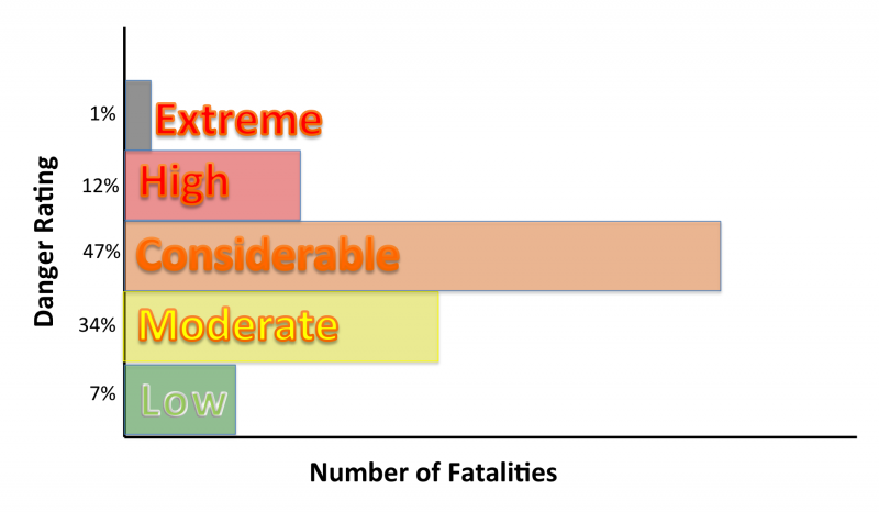
Overall, the avalanche danger rating is LOW as we generally have safe avalanche conditions. Watch for unstable snow on isolated terrain features. Natural and human-triggered avalanches are unlikely.
Pay attention to the snow surface on the southerlies. If you start seeing rollerballs or the snow becomes damp and unsupportable, it's time to get out of there or change your aspect to a cooler, more shady slope.
Low
Moderate
Considerable
High
Extreme
Learn how to read the forecast here
Weather and Snow
This morning, under mostly clear skies, there is currently an inversion in the mountains, with temperatures ranging from the upper teens to the low 30s °F. Winds are blowing from the south at speeds of 5-10 mph with the occasional gust to 15 mph.
Today, we can expect another beautiful day with overall calm winds, and clear skies. Clouds will begin to build by the afternoon, into the evening. Temperatures will climb into the upper 30s °F this afternoon, and winds will remain from the south with speeds of 5-15 mph.
Overnight, conditions will rapidly change as a cold front moves through the area late this evening into the early morning hours of Tuesday. Temperatures will drop, and snowfall will develop around 1 AM. Peak snowfall rates will occur during the early morning hours of Tuesday, but light snowfall could linger through the day. Expect 1-4" of new snow by Wednesday morning.

The wind and sun have taken their toll on the snow surface. Sun crusts on the sunnies are commonplace, and on the shadies you can expect stiff wind board on many upper elevation slopes and soft settled powder in the wind and sun-sheltered terrain.
Recent Avalanches
No new avalanche activity was reported yesterday.
Ad
Avalanche Problem #1
Normal Caution
Type
Location
Likelihood
Size
Description
This is not a specific avalanche problem. It is often used by UAC forecasters when avalanche conditions are generally safe and there is no predominant avalanche problem. Remember, that LOW avalanche danger does not mean NO avalanche danger. Any avalanche type is possible, but the most likely today would be wind slab, loose wet, and loose dry avalanches, which would be expected to be small.
Always practice safe travel techniques regardless of conditions. Continue to evaluate the snowpack and gather as much information as possible. Use test slopes that are representative of the terrain you wish to ski.

It's February, and the sun is getting stronger every day. If you find yourself in steep, sunlit terrain today, keep an eye on the snow surface. If you start seeing signs that the snow surface becoming damp and unsupportable, such as pinwheels, rollerballs or minor point releases below cliff bands, it's time to re-evaluate your terrain and change your aspect to a cooler, more shady slope.
Additional Information
Just wanted to share a fun brain nugget to discuss on the drive or skin track. Did you know that when the avalanche danger rating is at EXTREME that at that danger level, it only accounts for 1% of avalanche fatalities and that the LOW danger rating accounts for 7% of avalanche fatalities? Why do you think this is the case?
General Announcements
This information does not apply to developed ski areas or highways where avalanche control is normally done. This forecast is from the U.S.D.A. Forest Service, which is solely responsible for its content. This forecast describes general avalanche conditions and local variations always occur.