UDOT PLANNED AVALANCHE CLOSURES!!

Forecast for the Provo Area Mountains

Dave Kelly
Issued by Dave Kelly for
Monday, December 5, 2022
There is a CONSIDERABLE avalanche danger for today at mid and upper elevations. People in the backcountry continue to trigger avalanches on a persistent weak layer formed in mid November. As more wind transports new snow and loads this persistent weak layer the size of the avalanches will only increase.
These avalanches are not to be taken lightly as they will break 1-4' feet deep and up to 300' wide (perhaps wider). These avalanches can be triggered from a distance (remotely) and can travel long distances downhill into the flats.
Low elevations have a MODERATE danger. The same weak layer exists at low elevations but there is less snow on top of it.

Use cautious route finding and avoid traveling on or under slopes over 30 degrees.
Low
Moderate
Considerable
High
Extreme
Learn how to read the forecast here
Special Announcements
Join the Utah Avalanche Center and the Utah Division of Outdoor Recreation to celebrate the Fourth Annual Avalanche Awareness week from December 4 - December 11. Click HERE to view the full list of events for the week.
Weather and Snow
Under overcast skies with light snow falling mountain temperatures are in the 20's F. Winds are calm at lower elevations blowing westerly into the low teens MPH at the 9000' ridgelines. New snow blankets the Wasatch from the top of the mountains all the way to the valley. Ski areas reported a trace of new snow.
For today, snow 3-6" forecasted with periods of up to 1" an hour this morning. Temperatures 24-28 F with westerly winds 15 gusting to 25 MPH at the 9000' ridgelines and 25 gusting to 40 MPH at the 11,000' ridgelines. There will be a couple of waves of precipitation throughout the day. Expect to see periods of clearing followed by bursts of snow. Freezing level is forecast to be around 6400'.
Recent Avalanches
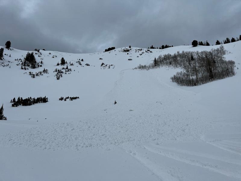
There was an observation of a snowbike triggered avalanche on an east aspect at 9400' on Ant Knolls. This avalanche was 18" deep and approximately 50' WIDE. This avalanche was remote triggered from 1000' away from the bottom of the slope.
Photo: Jed
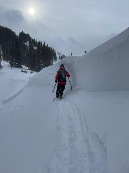
Yesterday the UAC joined Park City Snow Safety to look at an avalanche that was triggered late in the day on Saturday December 4th. This avalanche was within Park City Ski Area's boundary in closed terrain that is representative of a backcountry snowpack. This avalanche is one of the biggest reported thus far on the November drought layer.
Photo: deepest part of the crown 6' (Park City Snow Safety)

We continue to see deep avalanches reported by backcountry skiers and ski patrols. These avalanches will only get bigger as we add more snow and wind to an already weak layer. Yesterday we went to look at an avalanche near the Brighton periphery that ran into the flats on an east facing slope off Clayton Peak. The wind was continuing to re-load this slope and is a location where we are likely to see skier triggered avalanches in the future. Remember that as soon as you leave the ski area boundary you are in backcountry terrain.
Ad
Avalanche Problem #1
Persistent Weak Layer
Type
Location
Likelihood
Size
Description
The cold dry spell in November created a very weak snow surface composed of near surface facets and surface hoar on almost all aspects and elevations throughout the Wasatch. This layer was subsequently buried on the 27th of November and is now reacting to the new load on top of it. The weak layer is present and has been the guilty party in a number of recent avalanches. We are still trying to determine where the weak layer is present and will give suspect slopes a wide berth until we can show that the weak layer doesn't exist.
Recent high winds from the south added an additional very hard wind slab on top of this weak layer which has led to avalanches being triggered naturally and remotely to skiers and snowmobilers up to 6' deep and 300' wide. Today's new snow plus any possible wind drifting will make more avalanches likely today. These are unsurvivable avalanches. Any steep slope is suspect until proven otherwise and the best travel advice would be to avoid slopes over 30 degrees. Based on recent activity this travel advice includes any slope with overhanging terrain where you might trigger these facets from a distance.
Avalanche Problem #2
New Snow
Type
Location
Likelihood
Size
Description
A trace of new snow last night plus 3-6 inches falling today should produce loose dry avalanches in steep terrain.
General Announcements

This information does not apply to developed ski areas or highways where avalanche control is normally done. This forecast is from the U.S.D.A. Forest Service, which is solely responsible for its content. This forecast describes general avalanche conditions and local variations always occur.