Forecast for the Provo Area Mountains

Trent Meisenheimer
Issued by Trent Meisenheimer for
Sunday, December 4, 2022
Today we have a CONSIDERABLE avalanche danger on all mid and upper-elevation steep slopes where hard slabs of snow can break 1-4' deep and hundreds of feet wide, failing on a persistent weak layer of faceted snow. Avalanches can be triggered remotely (from a distance) and travel long distances into the flats.
My Advice: Back off steep terrain and ride slopes less than 30° in steepness with nothing steep above or adjacent to you.
Low
Moderate
Considerable
High
Extreme
Learn how to read the forecast here
Special Announcements
Join the Utah Avalanche Center and the Utah Division of Outdoor Recreation to celebrate the Fourth Annual Avalanche Awareness week from December 4 - December 11. Click HERE to view the full list of events for the week.
Weather and Snow
The National Weather Service has issued a Winter Weather Advisory from 6:00 PM Sunday to 9:00 PM Monday, where we could see 5-10 inches of new snow.
This morning, under mostly cloudy skies, the mountain temperatures range from 29-35 °F. Current ridgetop winds are blowing from the southwest at speeds of 10-15 mph with gusts into the 20's. Overnight a few snowflakes were squeezed from the sky, with Aspen Grove reporting a trace with 0.05" of SWE.
Today, you can expect partly to mostly cloudy skies and temperatures rising into the low to mid 30's °F. Winds will remain southerly and increase throughout the day as they usher in a cold front currently stalled around the Utah/Idaho border. Southerly winds are forecasted to reach speeds of 15-25 mph, gusting into the 30's & 40's across the upper-elevation terrain.
Recent Avalanches
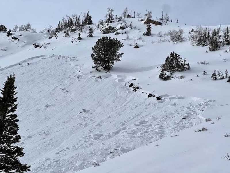
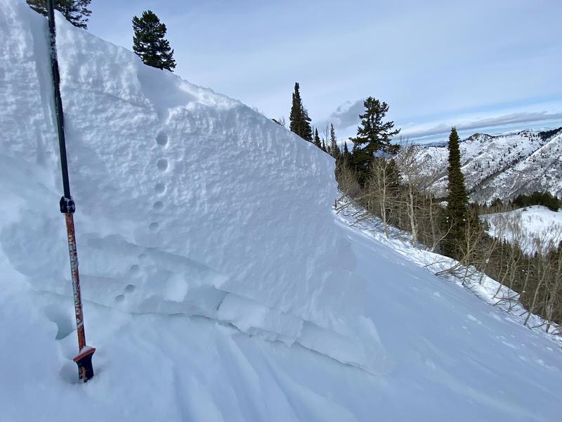
No new observations from the Provo area. Backcountry observers in the Cottonwoods continue to report large and dangerous avalanches, and many note cracking and collapsing on nearly every step they take. Check out all the recent avalanches HERE, as there are too many to list. Snow safety teams continue to trigger avalanches with explosives that are large enough to catch, carry, bury, and or kill a person.
If you see or trigger an avalanche adjacent to a ski area, please notify them. We've had two avalanches triggered the past two days where ski patrol and helicopters were called in because nobody reported the avalanches, and they have to assume someone could be buried.
Photo: Lemieux, Slab Avalanche Yesterday in West Monitor.
Ad
Avalanche Problem #1
Persistent Weak Layer
Type
Location
Likelihood
Size
Description
We had roughly 16 days of clear and cold weather in November, where our snowpack became weaker each day/night, creating a layer of weak faceted snow called a Persistent Weak Layer. This weak layer was buried on the 27th of November on almost all aspects and elevations throughout the mountains. Strong southerly winds and new snowfall over the past few days have overloaded this persistent weak layer, and we are now seeing deep and dangerous avalanches.
These avalanches are not to be taken lightly as they will break 1-4' feet deep and up to 300' wide (perhaps wider). These avalanches can be triggered from a distance (remotely) and can travel long distances downhill into the flats.
Photo: Nalli/White. This is a great photo showing the structure of the avalanche. Hard slab over weak snow.
Avalanche Problem #2
Wind Drifted Snow
Type
Location
Likelihood
Size
Description
Strong southerly winds over the past few days have changed the landscape where some slopes were stripped to dirt and others are drifted, with 1-4' deep (or deeper) hard slabs of snow sitting above a persistent weak layer of faceted snow. This has complicated the mountains as there is a huge amount of variability across the terrain.
Backcountry terrain where the wind has drifted or will continue to drift the snow into dense, hard slabs will be the most dangerous areas as the avalanche will likely break wider and deeper into the snowpack, creating a much larger and more dangerous avalanche (read above).
General Announcements

This information does not apply to developed ski areas or highways where avalanche control is normally done. This forecast is from the U.S.D.A. Forest Service, which is solely responsible for its content. This forecast describes general avalanche conditions and local variations always occur.