Check out our Holiday Auction - Sign Up for the Utah Snow and Avalanche Workshop (USAW)

Forecast for the Provo Area Mountains

Drew Hardesty
Issued by Drew Hardesty on
Wednesday morning, December 4, 2024
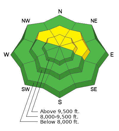
The avalanche danger is MODERATE on steep mid and upper elevation northerly to easterly facing slopes. In isolated areas, it may still be possible to trigger a 1-3' deep avalanche failing on a persistent weak layer of faceted grains. This layering is slowly stabilizing and may need another day or two before the danger drops to LOW. Otherwise, small wet or dry sluffs can by expected in steep terrain.
Low
Moderate
Considerable
High
Extreme
Learn how to read the forecast here
Special Announcements
The 17th Annual Utah Snow and Avalanche Workshop (USAW) is scheduled for Saturday, December 7th. Information and tickets are available here.
Weather and Snow
Skies are clear with light northwest winds and temps in the mid to upper 30s.
For today, we'll have sunny skies, light northwest winds and temps rising back into the upper 30s to upper 40s.
Riding conditions are hunt and peck in the mid to upper elevations, with a few soft turns found in between sun and wind damage.

The forecast largely remains the same: high and dry with a token storm late weekend. Might be enough for a few inches of snow.

Forecasters often struggle when dropping the avalanche danger to LOW. We seek consensus among the staff and among the professional avalanche community. But there is always an element of capital U uncertainty, particularly when a poor snowpack structure - a poor snowpack structure with a persistent weak layer - exists.
To that end, I have a couple complimentary essays to read:
Recent Avalanches
Many large natural slab avalanches ran with the storm last Tuesday with a few trickling in the days after that. None - as far as we know - were human triggered. The list is HERE. These slides were 1-3' deep and a few hundred feet wide on steep north to east facing slopes and primarily noted along the Cascade ridgeline in the south fork of Provo Canyon.
More recently, only wet loose avalanches have been reported with the warm temperatures.
Ad
Avalanche Problem #1
Persistent Weak Layer
Type
Location
Likelihood
Size
Description
A poor snowpack structure exists in the shady terrain of the mid and upper elevations. Here, you'll find 1-2' of recent storm snow over about a foot of early season weak sugary faceted snow. In our travels in the south fork on Sunday, we experienced no cracking or collapsing and snow tests were inconsistent at best. We came away with more questions than answers. Our observation can be found HERE. Trent Meisenheimer traveled from Tibble Fork to Silver Lake and up to Major Evans and found generally stable snow with a poor snowpack structure. You can find his observation HERE. Still, persistent weak layers of faceted grains are notoriously tricky and caution is warranted in steep terrain.
Video: Showing the slab over a weak layer propagate a crack with an extended column test. Big Springs, Provo.
General Announcements
This information does not apply to developed ski areas or highways where avalanche control is normally done. This forecast is from the U.S.D.A. Forest Service, which is solely responsible for its content. This forecast describes general avalanche conditions and local variations always occur.