UDOT PLANNED AVALANCHE CLOSURES!!

Forecast for the Provo Area Mountains

Greg Gagne
Issued by Greg Gagne on
Tuesday morning, December 25, 2018
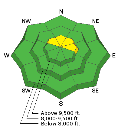
The avalanche hazard is generally LOW, but there is a MODERATE risk on upper elevation aspects facing northwest through east of triggering a small wind slab. There also exists a very isolated chance of triggering a larger avalanche breaking down near the ground in thinner snowpack areas above about 9500' on aspects facing north through east.
From our entire team at the Utah Avalanche Center, we wish you all a Very Merry Christmas!
Low
Moderate
Considerable
High
Extreme
Learn how to read the forecast here
Special Announcements
The new UAC IOS mobile app is now available on the app store. Check out the new "My Weather" feature.
Weather and Snow
Currently, skies are overcast with light mountain snow showers. The Provo-area mountains picked up 1-3” of snow yesterday, much of it dense graupel. Overnight, we received a stocking-stuffer gift with an additional trace to 2” of new snow. Winds are out of the south/southeast and generally light, with gusts in the 20’s mph above 10,000’ ridgelines. Overnight gusts at 11,000' were in the 30’s, with even a few gusts in the 40’s and 50’s. However, once you drop in elevation, winds diminish significantly. Temperatures overnight have risen by a few degrees, and most mountain stations are in the 20’s F.
For today, mountain temperatures will be in the 20's and low 30's F. Winds will be out of the south/southeast and generally light, with gusts in the 20's mph along upper elevation ridgelines. We may pick up a few inches of snow during the day, and again overnight.
Over the next few days we continue to pick up a few inches of snow for each 12-hour period, with brief ridging and colder temperatures by Friday.
Recent Avalanches
There were no reports of avalanches in the Provo mountains for Monday. Further north in the Salt Lake mountains, the only reports we received were pockets of small wind slabs.
Ad
Avalanche Problem #1
Wind Drifted Snow
Type
Location
Likelihood
Size
Description
Overnight, winds shifted to the south/southeast and increased slightly, so you may find a few isolated pockets of fresh and shallow wind drifts along the upper elevation ridgelines. Winds are forecasted to remain generally light today, and out of the south/southeast. But anytime I see "east" in forecasted wind direction, I'm suspicious as easterly winds create unusual loading patterns in the central Wasatch. Watch for possible drifting on north and northwest aspects if wind speeds increase, especially out of an easterly direction. Riders may also find an errant wind-slab on east aspects at the very uppermost elevations from yesterday's westerly winds.
Avalanche Problem #2
Persistent Weak Layer
Type
Location
Likelihood
Size
Description
This past Saturday in the Salt Lake mountains, our persistent weak layer problem came back from its dormancy with a human-triggered avalanche in Days Draw (observation). Although the chances of triggering an avalanche on this deeply-buried weak layer down near the ground is very remote, it remains possible. This problem exists on steep upper elevation aspects that face north and northeast, where the snowpack is thinner, less than 3 feet.
John Woodruff submitted an excellent observation from the Bunnell's Ridge area (observation) where he describes the overall snowpack, particularly focusing on where it is especially weak. This includes northwest aspects, as well as recently wind-loaded aspects facing north and northeast.
Don't want to deal with this problem? Avoid steep, upper elevation northerly slopes, especially in rocky terrain with a thin snowpack.
More comments about our persistent weak layer problem under Additional Info below.
Additional Information
Persistent weak layers of snow such as faceted crystals, depth hoar, and surface hoar can become very dangerous layers once they are buried. As its persistent adjective suggests, these weaknesses can exist for a very long time (i.e. weeks, months, all season long.) Our current persistent weak layer of loose, sugary faceted snow down near the ground had its origins back in October when the mountains received their first significant snowfall. Although most of the snow melted out, on northerly aspects this snow remained, where it metamorphosed into a layer of weak faceted snow at the ground due to a temperature gradient in the thin snowpack (click here to read more about this process). Complicating things, a rain event formed a crust, where we ultimately ended up with facets both above and below the crust.
By themselves, persistent weak layers are not an issue. They only become a problem once buried under new snowfall or wind-driven snow.
There are two reasons why some slopes have a thinner snowpack this season: (1) they avalanched previously (known as "repeaters") or (2) they are in areas that have received less snow. The slope in Days Draw appeared to have been a repeater from late November. The photo below shows the snowpack structure of the crown on the Days Draw avalanche, where the very weak layer of faceted snow down near the ground is clearly visible.
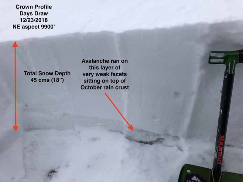
Generally, once a persistent weak layer becomes buried, it slowly adjusts to the load on top. In addition, the slab on top often gains enough strength where a rider cannot exert enough force on the buried weak layers. Without additional loading, the persistent weak layer gradually becomes dormant, but only to re-awaken with additional loading. We are likely in - or entering- a dormant phase, but the Days Draw avalanche surprised me because it did not undergo a substantial recent loading event, thereby suggesting this weak layer may not be entirely dormant.
From the best of our understanding, our persistent weak layer primarily exists on slopes above 9500' that face north and northeast, however weaknesses have also been reported on aspects facing northwest and east. The areas of greatest concern are on slopes that have a thinner snowpack, generally less than 3 feet.
General Announcements
This information does not apply to developed ski areas or highways where avalanche control is normally done. This forecast is from the U.S.D.A. Forest Service, which is solely responsible for its content. This forecast describes general avalanche conditions and local variations always occur.