Fall Auction is now live! Check it out now

Forecast for the Provo Area Mountains

Nikki Champion
Issued by Nikki Champion on
Thursday morning, December 22, 2022
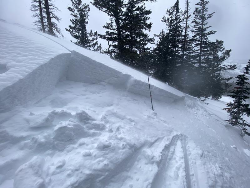
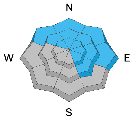
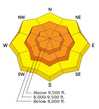
Due to sustained extremely high winds and new snow the avalanche danger is CONSIDERABLE on all aspects at upper and mid-elevations elevations where human-triggered avalanches are likely. Watch for and avoid any freshly formed wind drifts on all upper and mid-elevation slopes. Give extra caution to any slopes that receive the additional weight of wind-drifted snow facing northwest-north-northeast-east because of a persistent weak layer buried 1-4' deep.

The avalanche danger is MODERATE on low-elevation slopes that received overall less wind and less snow.

Any avalanche triggered within the wind-drifted snow has the potential to step down into deeper weak layers in the snowpack, creating a very large and dangerous avalanche.
Low
Moderate
Considerable
High
Extreme
Learn how to read the forecast here
Weather and Snow
As of 5 AM, snow totals are between 1-2" of new snow. The west-northwesterly winds are the true star of the show, currently averaging 20-60 mph with gusts up to 60 mph in the Provo are, and above 100 mph just outside the Provo area. The winds have now been consistently gusting above 50 mph for close to 12 hours. Temperatures are in the upper teens and low-20s F.
Today, winds will peak or will have peaked by the early morning hours before gradually decreasing throughout the day. Snowfall will continue with very little total accumulation, with an additional trace of 1" of new snow expected. Westerly winds will average 10-20 mph with gusts up to 35 mph at mid-elevations. At upper elevations, winds will gust up to 95 mph. . Temperatures will climb into the upper teens and low 20s F.
A weak storm system should make its way through the area Friday into Saturday bringing generally light snow to the area. Storm totals between 1-4" of new snow.
Recent Avalanches
There were no new avalanches reported from the Provo area mountains.
In the central Wasatch, there were multiple reports of sensitive soft slabs of wind-drifted snow easily triggered from ridgetops and ridgelines. Most of these avalanches failed 12-16" deep, failing on a new snow/old snow interface or weak faceted snow. Reports of both natural hard slab and soft slab avalanches of wind-drifted snow in the Upper Cottonwoods as well.
Soft slab of wind-drifted snow intentionally triggered on a North Aspect at 9400' off of 10420 in the Cottonwoods. (Hardesty, Torrey)

Observers continue to report poor snowpack structure in the lower elevation areas outside of the upper Cottonwood Canyons.
Ad
Avalanche Problem #1
Wind Drifted Snow
Type
Location
Likelihood
Size
Description
Winds have been gusting close to or over 50 mph all night. Such strong winds in combination with new snow will continue to form both soft and hard slabs of wind-drifted snow on all aspects at the mid and upper elevations, and even low-elevation terrain features that allow for drifting snow to accumulate. As the winds continue to blow, these slabs will become more firm and more cohesive. This can allow you to travel out farther onto the slope before it breaks, and can fail larger and wider than expected.
Although the winds have been mainly from the west/northwest, sustained winds this strong can channel snow around terrain features and create fresh drifts on all aspects, including well-down off of ridge lines. You may even find fresh wind drifts at unusually low elevations. Remember, wind can deposit snow 10 times more rapidly than snow falling from the sky. The high winds over the last 24 hours are going to create strange and dangerous conditions. With so many hours of such high and so much soft snow that was available for transport, I expect the size and sensitivity of the wind drifts to have increased drastically since yesterday morning. I fear these conditions could catch someone off guard today.
What to do? Look for evidence of fresh drifted slopes, or wind slabs that look wavy, rounded, smooth, and pillow, and avoid travel on or below those slopes.
Any wind slab avalanche that you trigger has the potential to step down into deeper weak layers in the snowpack, creating a very large and dangerous avalanche.
Avalanche Problem #2
Persistent Weak Layer
Type
Location
Likelihood
Size
Description
There is weak, sugary faceted snow (a persistent weak layer, or PWL) buried 1-4' deep on almost all aspects and elevations throughout the Wasatch Range. Avalanches on this layer are most likely on slopes facing northwest-north-east-southeast.
Today, the likelihood will be especially prominent on any slopes that receive the additional weight of wind-drifted snow. For the snowpack, when the winds drift snow, it's the same as if snow is falling out of the sky. The snowpack doesn't care where the snow comes from, it feels the added weight. So, on northerly-facing slopes, these winds have added snow and weight, and stress to the persistent weak layer. Due the consistent northwesterly winds, we know that the southeasterly facing slopes have been receiving the brunt of the snow load, and we could begin to overload those weak faceted grains and see activity on these aspects again at upper and mid-elevations.
Avalanches are unlikely on solar aspects west through south where there haven't been any reported avalanches on this layer. The easiest way to avoid any avalanche is to go on slopes less than 30 degrees with nothing steeper above. Read about slope selection HERE.
Additional Information
Read about decision making during MODERATE hazard HERE.
General Announcements
As the end of the year approaches, please consider a donation to the UAC to support avalanche forecasting.

This information does not apply to developed ski areas or highways where avalanche control is normally done. This forecast is from the U.S.D.A. Forest Service, which is solely responsible for its content. This forecast describes general avalanche conditions and local variations always occur.