Forecast for the Provo Area Mountains

Drew Hardesty
Issued by Drew Hardesty for
Monday, November 28, 2022
It will be a day of changing conditions and a rising avalanche danger.
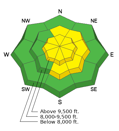
The avalanche danger will rise to MODERATE for developing pockets of wind drifted snow. Human triggered avalanches will be possible in the mid and upper elevations.
Low
Moderate
Considerable
High
Extreme
Learn how to read the forecast here
Special Announcements
Join the Utah Avalanche Center and the Division of Outdoor Recreation to celebrate the Fourth Annual Avalanche Awareness week, from December 4 - December 11. Click HERE to view the full list of events for the week.
Weather and Snow
Skies are overcast ahead of the first in a series of storm systems for the Wasatch.
Mountain temperatures are in the mid to upper-20s. Winds are out of the west-southwest, blowing 25mph with gusts to 35. The highest elevations have hourly averages of 30mph with gusts to 40.
A cold Pacific storm is on the doorstep and we'll see light snowfall through much of the day. Snowfall intensity will spike during and just after the arrival of the cold front, estimated to arrive during the afternoon commute. Winds will veer to the west northwest and be gusty for a few hours into the evening. By early evening, favored locations could see upwards of 3-6", with snowfall continuing through the night and into Tuesday. Lake effect is possible, with the flow favoring areas north of I-80. By later Tuesday, the Provo mountains should see storm totals of 4-8" or more, with temperatures plummeting to the single digits and low teens.
A warming trend follows for mid-week with the next storm slated for Thursday evening.

Provo snow depths are 1-2' and travel is relatively easy for this time of year. Wind and sun damage exist in the upper elevations and the solar aspects, respectively; this storm will be a nice refresher.
From Ogden to the central Wasatch to the Provo mountains, we have received several excellent observations. You can find them HERE. Please keep these reports coming.
Recent Avalanches
None.
Ad
Avalanche Problem #1
Wind Drifted Snow
Type
Location
Likelihood
Size
Description
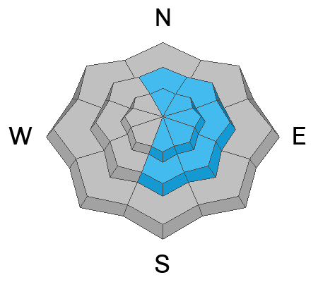
In the past 18 hours, we've seen some of the more consistently moderate to strong winds since last Wednesday. With plenty of snow available for transport and more on the way, human triggered soft slab avalanches will be increasingly possible in steep wind drifted terrain. These shallow drifts will be more prevalent on north to east to south facing aspects. I would approach any new wind drift with caution and fully aware that drifts may be equally problematic at the mid as well as the upper elevations. Shooting cracks and audible "whumphs" are signs of instability. With enough loading, some of these drifts may be triggered at a distance.
TREND: INCREASING
Additional Information
Owing to the prolonged dry spell, the snow surface has become excessively weak and faceted on - at a minimum - northwesterly to northerly to easterly facing aspects. Patches of surface hoar exist in the more protected terrain. Once buried with a cohesive slab of snow, these layers will become problematic as a PWL (persistent weak layer) in that they (1) remain prone to avalanching with subsequent loading events (snowfall and/or wind) and (b) become tricky and often more unpredictable than other types of avalanches. Avalanches involving PWLs account for most of our accidents and fatalities.
These layers of faceted snow are so weak that I don't believe it will take much for them to become active and dangerous. I don't think we'll see them widespread and particularly active today; tomorrow, however may be a different story.
General Announcements

This information does not apply to developed ski areas or highways where avalanche control is normally done. This forecast is from the U.S.D.A. Forest Service, which is solely responsible for its content. This forecast describes general avalanche conditions and local variations always occur.