Fall Auction is now live! Check it out now

Forecast for the Provo Area Mountains

Drew Hardesty
Issued by Drew Hardesty on
Tuesday morning, November 29, 2022
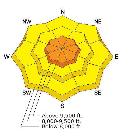
A CONSIDERABLE AVALANCHE DANGER exists in steep terrain in the upper elevations. Human triggered avalanches are likely, particularly on steep wind drifted slopes. Human triggered avalanches are possible at the mid and low elevations. On some west to north to east facing aspects, you will be able to trigger soft slab avalanches at a distance. Collapsing and shooting cracks are indicators of potentially dangerous avalanche conditions.
Low
Moderate
Considerable
High
Extreme
Learn how to read the forecast here
Special Announcements
Join the Utah Avalanche Center and the Division of Outdoor Recreation to celebrate the Fourth Annual Avalanche Awareness week, from December 4 - December 11. Click HERE to view the full list of events for the week.
Weather and Snow
Overnight snow totals are 6-10" of very low density snow (0.35"-0.56" snow water equivalent.). Winds are 20-25mph out of the west northwest. Temps are in the single digits and low teens. For today, we'll have snow showers in the morning with moderate west winds. Temps will be in the teens. Snow depths are 2-3'.

We'll start to dry out tonight and tomorrow as the flow backs to the southwest and increases Wednesday/Wednesday night ahead of another storm Thursday night into Friday. Another storm is expected late weekend into early next week.

From Ogden to the central Wasatch to the Provo mountains, we have received several excellent observations. You can find them HERE. Please keep these reports coming.
Ad
Avalanche Problem #1
New Snow
Type
Location
Likelihood
Size
Description
You will be able to trigger both loose snow and soft slab avalanches in the new snow in steep terrain. Avalanches may fail both within the new snow and at the interface of our November drought layer of weak sugary facets...leading to larger and more dangerous avalanches (see photo above).
Avalanche Problem #2
Wind Drifted Snow
Type
Location
Likelihood
Size
Description
Moderate to strong westerly-northwest winds will easily whip the low density snow into cohesive slabs on many aspects at the mid and upper elevations. Wind loading will be most prevalent on north through east through south facing aspects, but soft slabs of wind blown snow may be found on any aspect. Avoid any steep wind drifted areas: lee of ridgelines, cross-loaded gullies, around rocky outcroppings, etc.
On steep west to north to east facing slopes, avalanches may fail both within the new snow and at the interface of our November drought layer of weak sugary facets...leading to larger and more dangerous avalanches. (see photo above).
Additional Information
Owing to the prolonged dry spell, the snow surface has become excessively weak and faceted on - at a minimum - westerly to northerly to easterly facing aspects. Patches of surface hoar exist in the more protected terrain. Once buried with a cohesive slab of snow, these layers will become problematic as a PWL (persistent weak layer) in that they (1) remain prone to avalanching with subsequent loading events (snowfall and/or wind) and (b) become tricky and often more unpredictable than other types of avalanches. Avalanches involving PWLs account for most of our accidents and fatalities.
These layers of faceted snow are so weak that I don't believe it will take much for them to become active and dangerous.
General Announcements

This information does not apply to developed ski areas or highways where avalanche control is normally done. This forecast is from the U.S.D.A. Forest Service, which is solely responsible for its content. This forecast describes general avalanche conditions and local variations always occur.