Join us at our 2nd Annual Blizzard Ball

Forecast for the Provo Area Mountains

Nikki Champion
Issued by Nikki Champion on
Thursday morning, January 9, 2025
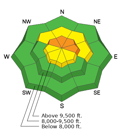
Avalanche danger is CONSIDERABLE on upper-elevation slopes facing northwest through east, with large, destructive slides possible on a buried weak layer 1–3+ feet deep. Avalanches can be triggered remotely or from below.
Any avalanches triggered in wind-drifted snow could step down to deeper weak layers.

Conditions remain dangerous despite becoming more stubborn. Avoid slopes steeper than 30 degrees with poor snow structure; stick to lower-angled terrain for safer travel and good riding.
Low
Moderate
Considerable
High
Extreme
Learn how to read the forecast here
Special Announcements
Receive forecast region-specific text message alerts to receive messages about changing avalanche conditions, watches, and warnings. Sign up and update your preferences HERE.
Weather and Snow
This Morning, Skies are mostly clear, with temperatures ranging from the single digits to low teens. Overnight, winds shifted from northwesterly to east-northeasterly, with gusts reaching up to 70 mph along the highest ridgelines. Winds have now eased to 15–20 mph at mid-elevations, with gusts up to 36 mph at the highest peaks.
Today, Low clouds may linger until mid-morning, but skies will clear, and the sun should be out by mid-afternoon. Temperatures will rise into the mid-20s°F. Northeasterly winds will stay moderate, averaging 5-10 mph at mid-elevations and 20–25 mph at upper elevations, with gusts up to 40 mph on the highest peaks.
Outlook: A storm system will arrive Friday evening and continue through the weekend. Snowfall will be light due to limited moisture and unfavorable wind patterns. Expected totals range from 1 inch (low end) to a few inches, with minimal water content.
Recent Avalanches
The backcountry remained relatively quiet overall, with no new avalanches reported in the Provo area mountains. However, ski patrols just north of Provo triggered several large hard slabs with explosives, which failed on old-faceted snow.
Be sure to check recent observations and avalanche reports to get a better understanding of current conditions across the range.
Ad
Avalanche Problem #1
Persistent Weak Layer
Type
Location
Likelihood
Size
Description
The main concern is triggering a large, deadly hard slab avalanche on a persistent weak layer buried 1–3+ feet deep, especially on mid- and upper-elevation slopes facing west through east.
While signs of instability are decreasing and the snowpack is slowly gaining strength, the consequences remain severe.
Thinner snowpack areas are particularly dangerous, and avalanches can still be triggered remotely or from below. Stay cautious and prioritize safety.
Avalanche Problem #2
Wind Drifted Snow
Type
Location
Likelihood
Size
Description
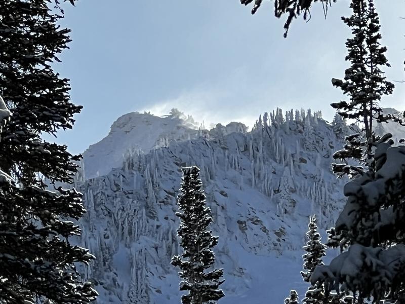
Overnight, strong northwesterly winds (up to 70 mph) shifted to unpredictable northeasterly winds this morning, creating sensitive wind slabs at upper elevations. Look for wind-drifted snow, like pillow-shaped deposits, and avoid those slopes. The safest riding is in sheltered, lower-angle terrain out of the wind.

Photo of the NE winds from Greg's day in Maybird Tuesday.
Additional Information
The accident reports for the Porter Fork and Davenport Hill Accident have been completed. You can read them HERE.
At the Utah Avalanche Center, we strive to learn from every avalanche incident and share insights to help others avoid similar accidents. We have all experienced close calls and understand how easily mistakes can happen. Our goal with these reports is to provide valuable learning opportunities.
General Announcements
This information does not apply to developed ski areas or highways where avalanche control is normally done. This forecast is from the U.S.D.A. Forest Service, which is solely responsible for its content. This forecast describes general avalanche conditions and local variations always occur.