Forecast for the Provo Area Mountains

Trent Meisenheimer
Issued by Trent Meisenheimer for
Sunday, January 29, 2023
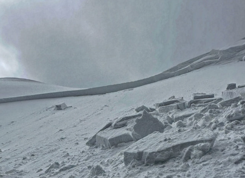
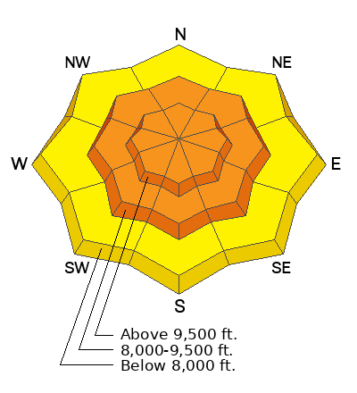
The avalanche danger is CONSIDERABLE across all mid and upper elevations for sensitive slabs of wind-drifted snow. We also have a CONSIDERABLE avalanche danger for new snow soft slabs and dry-loose avalanches. Human-triggered avalanches are likely, and natural avalanches are possible.

We could see a period of heavy snowfall where the avalanche danger could spike to a HIGH danger for a few hours. This will depend on your location and how fast the snow falls from the sky.
Low
Moderate
Considerable
High
Extreme
Learn how to read the forecast here
Weather and Snow
The National Weather Service has issued another Winter Weather Advisory until 8:00 am Monday. As I write this forecast, the first snowflakes just started to fall, with snow sites reporting the first bit of water from the storm. Mountain temperatures are in the teens and low 20s °F. Winds have backed to the west-south-west this morning and are blowing 15-25 mph gusting into the 30s across many upper-elevation wind sites.
Today we will see heavy snowfall at times, with the most intense period between 8:00 am and 2:00 pm before it tapers off by early evening. During this period, we could see snow rates of 2 inches per hour, with storm totals throughout the day adding up to 5-9 inches of new snow. Mountain temperatures will top out in the low to mid-twenties °F. Winds will continue to blow west-southwest at speeds of 10-20 mph, gusting into the 30s.
There is powder snow on all aspects and elevations, and the riding and turning conditions are legendary.
Recent Avalanches
By my count, there were 24 human-triggered avalanches yesterday, with 6 people getting caught and carried, with one person ending up injured. The list of avalanche observations is literally too long to include here, so be sure to check it out HERE.
Photo: White. Wind Slab.
Ad
Avalanche Problem #1
Wind Drifted Snow
Type
Location
Likelihood
Size
Description
For the past 24 to 48 hours, the west-northwest winds have blown steady at 10-25 mph across the mid and upper elevations. This morning the west-southwest winds are currently blowing 10-20 mph gusting into the 30, and it's pretty straightforward, based on the recent avalanche activity, that you can trigger slabs of wind-drifted snow 12-24 inches deep and up to 250 wide. Don't be fooled into thinking it's stable out there. It's clearly unstable.
Unfortunately, yesterday's wind slabs will now be buried by this morning's new snow, making it more difficult to spot which slopes are loaded and which ones are not. My advice would be to back off today, ride slopes under 30° in steepness, and let this snow stabilize for a few days.
Avalanche Problem #2
New Snow
Type
Location
Likelihood
Size
Description
This morning's forecast of snowfall rates hitting 2 inches per hour has me concerned. If that forecast comes true, we could see periods of HIGH avalanche danger where avalanches fail within the new storm snow. New snow instabilities could include:
  • Soft slabs that fail within the new snow.
  • Loose-dry avalanches running fast and far.
  • Natural avalanches on all aspects during high precipitation intensity (heavy snowfall).
General Announcements
This information does not apply to developed ski areas or highways where avalanche control is normally done. This forecast is from the U.S.D.A. Forest Service, which is solely responsible for its content. This forecast describes general avalanche conditions and local variations always occur.